- My Forums
- Tiger Rant
- LSU Recruiting
- SEC Rant
- Saints Talk
- Pelicans Talk
- More Sports Board
- Fantasy Sports
- Golf Board
- Soccer Board
- O-T Lounge
- Tech Board
- Home/Garden Board
- Outdoor Board
- Health/Fitness Board
- Movie/TV Board
- Book Board
- Music Board
- Political Talk
- Money Talk
- Fark Board
- Gaming Board
- Travel Board
- Food/Drink Board
- Ticket Exchange
- TD Help Board
Customize My Forums- View All Forums
- Show Left Links
- Topic Sort Options
- Trending Topics
- Recent Topics
- Active Topics
Started By
Message
re: TS Arthur - TS Warning for SE Texas and SW Louisiana - Flood Threat
Posted on 6/17/26 at 5:46 pm to LSURoss

Posted on 6/17/26 at 5:46 pm to LSURoss
Tangipahoa river looked high as hell on the way home from work. I didn't check the Tchefuncte but it's not going to be pretty if the northshore gets too much rain tonight.
 0
0

Posted on 6/17/26 at 5:55 pm to rds dc
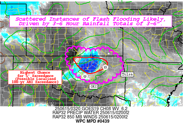
The next 12 to 24 hrs will be the period to watch for heavy rain and flash flooding. The 21z HRRR has totals pushing 20" in SW Louisiana, while the 18z RRFS (New model that will replace some of the current hi-res models in August) has 20"+ across the Florida Parishes.


Posted on 6/17/26 at 5:58 pm to rds dc

What model is this and is it reliable?
Posted on 6/17/26 at 5:59 pm to TDsngumbo
quote:
What model is this and is it reliable?
I don't know, since they didn't include a data source for the image.

Posted on 6/17/26 at 6:00 pm to rds dc
Calling my shot now
BR gets 3.5 inches of rain
BR gets 3.5 inches of rain
Posted on 6/17/26 at 6:02 pm to Bayou_Tiger_225
Your mom’s getting all my 3.5” that’s for sure.
Posted on 6/17/26 at 6:03 pm to rds dc
Gotcha. I figured you’d be able to recognize where it came from. Maybe that’s some sort of in-house model for them.
Posted on 6/17/26 at 6:04 pm to Bayou_Tiger_225
Gonna be one puddle in the road and a chair that fell over in a random back yard.
Posted on 6/17/26 at 6:28 pm to tigafan4life
I hope you're right
Posted on 6/17/26 at 6:32 pm to TDsngumbo
quote:Braggart!!
all my 3.5”

Posted on 6/17/26 at 6:34 pm to TDsngumbo
quote:
Your mom’s getting all my 3.5” that’s for sure.
quote:
Bayou_Tiger_225


Posted on 6/17/26 at 7:04 pm to Bobby OG Johnson
This is weird. At work in Beaumont Texas and it is clear as a bell with a nice 10 mph breeze. Right next to the “storm” 200 miles east of here raining cats and dogs.
Posted on 6/17/26 at 7:06 pm to rds dc
Mesoscale Precipitation Discussion 0439
NWS Weather Prediction Center College Park MD
800 PM EDT Wed Jun 17 2026
Areas affected...Southeast Louisiana
Concerning...Heavy rainfall...Flash flooding likely
Valid 180000Z - 180600Z
Summary...Showers and thunderstorms grow in coverage and intensity
through this evening over southeast Louisiana. Scattered flash
flooding can be expected through midnight before the focus shifts
farther inland. Expect repeating activity with rain rates of 2"+
per hour and 5"+ totals through midnight.
Discussion...As of 00Z, an MCV associated with a mid-level
circulation east of Arthur is tracking north toward the Louisiana
coast. Extremely high moisture and sufficient instability is
present ahead of this wave with PW around 2.6" (3.5 sigma above
normal) and SBCAPE around 2000 J/kg. Scattered showers and
isolated thunderstorms are across southeast Louisiana with rain
estimates generally 1 to 1.5"/hr from KHDC. Activity thus far has
avoided NOLA and Baton Rouge, but increasing coverage and
intensity will bring heightened threats to both these sensitive
areas as well as the rest of southeast LA through the evening
hours.
Notable differences are present in recent HRRR and RRFS output
with the HRRR unreasonably west (given MCV placement) over
south-central LA while the placement in recent RRFS to the east
(including NOLA) are reasonable. Both have 6hr QPF of 5-8" maxes
which is reasonable given the extreme PW and a forcing mechanism
slowly approaching the coast allowing redevelopment/repetition.
QPF of this magnitude (with locally higher 6hr max possible)
brings up a concern for considerable impacts to the flash flood
threat. Antecedent conditions are thankfully rather dry for much
of the area, but this amount of QPF over a potentially larger than
normal area warrants likely and considerable wording for this
flash flood threat through midnight.
The activity will be pushing farther inland overnight, but
additional localized heavy rain should warrant further discussion
for southeast LA let alone into through southern MS.
Jackson
Posted on 6/17/26 at 7:07 pm to BOSCEAUX
quote:
This is weird. At work in Beaumont Texas and it is clear as a bell with a nice 10 mph breeze. Right next to the “storm” 200 miles east of here raining cats and dogs.
Upper-level winds have displaced convection well away from the center of the system.
Posted on 6/17/26 at 7:09 pm to rds dc
quote:
Upper-level winds have displaced convection well away from the center of the system.
With what you said should this area still be under a TS warning?
Posted on 6/17/26 at 7:14 pm to Alt26
It’s interesting for sure. Bob Breck doesn’t seem concerned and Scott Pile says possible heavy bands northshore, Florida Parishes to Baton Rouge.

Posted on 6/17/26 at 7:28 pm to Dixie2023
Looks like some training bands trying to set up scattered between the basin and northshore
Posted on 6/17/26 at 7:33 pm to rds dc
23z HRRR sticks with a SW Louisiana bullseye, but that is probably too far west given the current setup. However, we are seeing the risk of a big rain event show up across multiple models this afternoon and evening.

Posted on 6/17/26 at 7:35 pm to rds dc
Driving back from Orlando tomorrow. Will this thing go North or am I driving through it?
Posted on 6/17/26 at 7:38 pm to rds dc
Where can I get that to be able to click a few locations and determine rainfall forecast?

 Page 13 of 16

Popular
Back to top