- My Forums
- Tiger Rant
- LSU Recruiting
- SEC Rant
- Saints Talk
- Pelicans Talk
- More Sports Board
- Fantasy Sports
- Golf Board
- Soccer Board
- O-T Lounge
- Tech Board
- Home/Garden Board
- Outdoor Board
- Health/Fitness Board
- Movie/TV Board
- Book Board
- Music Board
- Political Talk
- Money Talk
- Fark Board
- Gaming Board
- Travel Board
- Food/Drink Board
- Ticket Exchange
- TD Help Board
Customize My Forums- View All Forums
- Show Left Links
- Topic Sort Options
- Trending Topics
- Recent Topics
- Active Topics
Started By
Message
re: Tropical Storm Isaias - O Canada!
Posted on 8/1/20 at 8:43 am to Bobby OG Johnson
Posted on 8/1/20 at 8:43 am to Bobby OG Johnson
quote:
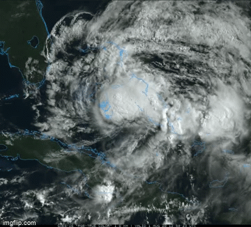
Case of the struggles this morning
If it wasn't for recon, you could argue that looks like a TD.
Radar doesn't look much better at this time with any hurricane conditions likely being confined to that narrow band of convection near the north end of the island.

 3
3

Posted on 8/1/20 at 8:46 am to rds dc
Give me your 2 cents about Delaware on Monday, and Tuesday. Monday ok, and lot of rain hitting there Tuesday?
Posted on 8/1/20 at 9:01 am to rds dc
quote:
Is that what they call a unorganized less than Cat 1 hurricane
this is the 1st hurricane to impact land this year where they had a few days of knowing hurricane impacts were near (Hanna kinda blew up right off the coast and was only a hurricane for a few hours before landfall)
I think anytime we have a hurricane truly threaten land in advance this year... TWC is going to use these stupid, terrible "COVIDcane 2020: Bracing for Disaster" graphics
by the way... Malkoff's story last night was more than just that 1 segment that I pointed out... during the story it sounded like he was actively trying to shame people who were out on the beach and not wearing masks
This post was edited on 8/1/20 at 9:12 am
Posted on 8/1/20 at 9:02 am to rds dc
quote:
If it wasn't for recon, you could argue that looks like a TD.
Radar doesn't look much better at this time with any hurricane conditions likely being confined to that narrow band of convection near the north end of the island.
the combo of shear and dry air finally doing work on Isaias


Posted on 8/1/20 at 9:32 am to Bobby OG Johnson
How worried should I be if I’m supposed to be flying into Miami Sunday afternoon? Chances flight gets cancelled?
Posted on 8/1/20 at 9:34 am to rds dc
After this system there will be another junk system out in the open Atlantic and then things look bad starting in mid-August. Both the CFS and EPS are showing a very favorable background state across the Atlantic and that will be superimposed over peak season. Buckle up.


Posted on 8/1/20 at 10:12 am to TigahJay
quote:
How worried should I be if I’m supposed to be flying into Miami Sunday afternoon? Chances flight gets cancelled?
Will be looooong gone.
ETA: This thing is a godsend weather wise. It's sunny and breezy here at the beach in PBC this morning. It's been insanely hot and humid.
This post was edited on 8/1/20 at 10:15 am
Posted on 8/1/20 at 10:19 am to rds dc
Cloud tops near the center have really started to warm over the past hour.

Posted on 8/1/20 at 10:28 am to rds dc
quote:
After this system there will be another junk system out in the open Atlantic and then things look bad starting in mid-August. Both the CFS and EPS are showing a very favorable background state across the Atlantic and that will be superimposed over peak season. Buckle up.
With as wet as the Sahel has been and the wave train it's been rolling with, concerning look to say the least into the heart of the season.
Isaias looks ragged AF this morning at least.

Posted on 8/1/20 at 10:43 am to rds dc
This nothing burger might not even hold together before it gets to Florida.
Posted on 8/1/20 at 10:52 am to The Boat
Looks like it might be slinging an outflow boundary out the west side. Storms collapsing in the core is what that suggests.
Posted on 8/1/20 at 11:55 am to Duke
Yall bracing for this Covidcane??
Posted on 8/1/20 at 12:20 pm to Lsuhoohoo
Looks like it won’t even make it to Florida. It’s dying.

Posted on 8/1/20 at 12:24 pm to Python
Dry air.........
Posted on 8/1/20 at 12:45 pm to Duke
What are the chances it just goes poof? Actually it kinda looks like it already has.

Posted on 8/1/20 at 12:50 pm to rds dc
quote:
things look bad starting in mid-August. Both the CFS and EPS are showing a very favorable background state across the Atlantic and that will be superimposed over peak season. Buckle up.


Posted on 8/1/20 at 2:10 pm to rds dc
Lost much of the deep convection but the low level circulation is still strong. Can he regenerate deep convection?


 Page 40 of 50

Popular
Back to top