- My Forums
- Tiger Rant
- LSU Recruiting
- SEC Rant
- Saints Talk
- Pelicans Talk
- More Sports Board
- Fantasy Sports
- Golf Board
- Soccer Board
- O-T Lounge
- Tech Board
- Home/Garden Board
- Outdoor Board
- Health/Fitness Board
- Movie/TV Board
- Book Board
- Music Board
- Political Talk
- Money Talk
- Fark Board
- Gaming Board
- Travel Board
- Food/Drink Board
- Ticket Exchange
- TD Help Board
Customize My Forums- View All Forums
- Show Left Links
- Topic Sort Options
- Trending Topics
- Recent Topics
- Active Topics
Started By
Message
re: Tropical Storm Isaias - O Canada!
Posted on 7/31/20 at 4:04 pm to Roll Tide Ravens

Posted on 7/31/20 at 4:04 pm to Roll Tide Ravens
New advisory with hurricane warnings up for portions of the east coast of Florida:

 0
0

Posted on 7/31/20 at 4:08 pm to Roll Tide Ravens
quote:
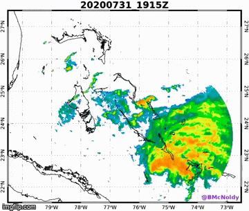
Isaias looks pretty good on radar:
Kind of looks like a big supercell. If not for the little bit of banding to the SE...

WV has a pretty nice moist envelope around Isaias but the center is basically on the western edge thanks to the shear. All pushing it to the NE.

Posted on 7/31/20 at 4:17 pm to Roll Tide Ravens
quote:
Isaias looks pretty good on radar:
Recon inbound and will give a lot more detail. Radar looks like some dry air coming off the end of Cuba possibly working into the eastern circulation? Wouldn't be surprising give that convection has been rotating upshear with an open eyewall.
Posted on 7/31/20 at 4:27 pm to rds dc
Experts - Is that the partial eyewall in the SW part of the CDO?

Posted on 7/31/20 at 5:01 pm to NorthEndZone

Uhh...not great to see the eye looking like it's just about closed off.
Posted on 7/31/20 at 5:08 pm to Duke
meanwhile... back at the ranch... it looks like I'm about to get dumped on
looks like a front is trying to come through central Louisiana right now
looks like a front is trying to come through central Louisiana right now

Posted on 7/31/20 at 5:10 pm to rt3
Dr McNabb on TWC just said..
Come Monday
it'll be in the Carolinas
great Jimmy Buffet
reference

Come Monday
it'll be in the Carolinas
great Jimmy Buffet
reference
This post was edited on 7/31/20 at 5:11 pm
Posted on 7/31/20 at 5:12 pm to Duke
This thing got its shite together in the past hour
Posted on 7/31/20 at 5:13 pm to rt3
quote:
looks like a front is trying to come through central Louisiana right now
There is a front coming through but it's late July so kind of in name only temp wise.
Posted on 7/31/20 at 5:14 pm to Duke
quote:
a pretty nice moist envelope
Posted on 7/31/20 at 6:03 pm to rds dc
Nice little overshooting top casting a shadow.

Posted on 7/31/20 at 6:29 pm to rds dc
couple of titty clouds
Posted on 7/31/20 at 6:42 pm to razorbackfan4life
quote:
couple of titty clouds
This one should have been “Dolly”.
Posted on 7/31/20 at 7:04 pm to Nicky Parrish
Looks like the eye is getting pretty closed off.

Posted on 7/31/20 at 8:07 pm to Roll Tide Ravens
About to enter its best chance for strengthening.
It’s going to make a south FL landfall and shoot up the spine of FL.
It’s going to make a south FL landfall and shoot up the spine of FL.
Posted on 7/31/20 at 8:51 pm to Bobby OG Johnson
Eyewall back open. That'll arrest the strengthening for a bit.
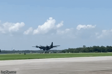
Posted on 7/31/20 at 8:53 pm to rds dc
Product: Air Force Vortex Message (URNT12 KNHC)
Transmitted: 1st day of the month at 1:32Z
Agency: United States Air Force
Aircraft: Lockheed WC-130J Hercules with reg. number AF97-5305
Storm Number & Year: 09 in 2020
Storm Name: Isaias (flight in the North Atlantic basin)
Mission Number: 9
Observation Number: 18
A. Time of Center Fix: 1st day of the month at 0:59:20Z
B. Center Fix Coordinates: 22.98N 76.07W
B. Center Fix Location: 161 statute miles (259 km) to the NE (47°) from Camagüey, Cuba.
C. Minimum Height at Standard Level: 1,321m (4,334ft) at 850mb
D. Minimum Sea Level Pressure: 987mb (29.15 inHg)
E. Dropsonde Surface Wind at Center: From 350° at 6kts (From the N at 7mph)
F. Eye Character: Open in the south
G. Eye Shape & Diameter: Circular with a diameter of 22 nautical miles (25 statute miles)
H. Estimated (by SFMR or visually) Maximum Surface Wind Inbound: 62kts (71.3mph)
I. Location & Time of the Estimated Maximum Surface Wind Inbound: 6 nautical miles to the ENE (66°) of center fix at 0:57:30Z
J. Maximum Flight Level Wind Inbound: From 162° at 81kts (From the SSE at 93.2mph)
K. Location & Time of the Maximum Flight Level Wind Inbound: 7 nautical miles to the ENE (68°) of center fix at 0:57:00Z
L. Estimated (by SFMR or visually) Maximum Surface Wind Outbound: 53kts (61.0mph)
M. Location & Time of the Estimated Maximum Surface Wind Outbound: 6 nautical miles to the SW (232°) of center fix at 1:01:30Z
N. Maximum Flight Level Wind Outbound: From 315° at 51kts (From the NW at 58.7mph)
O. Location & Time of the Maximum Flight Level Wind Outbound: 6 nautical miles to the SW (232°) of center fix at 1:01:30Z
P. Maximum Flight Level Temp & Pressure Altitude Outside Eye: 20°C (68°F) at a pressure alt. of 1,517m (4,977ft)
Q. Maximum Flight Level Temp & Pressure Altitude Inside Eye: 25°C (77°F) at a pressure alt. of 1,510m (4,954ft)
R. Dewpoint Temp (collected at same location as temp inside eye): 22°C (72°F)
R. Sea Surface Temp (collected at same location as temp inside eye): Not Available
S. Fix Determined By: Penetration, Radar, Wind, Pressure and Temperature
S. Fix Levels (surface & flight level centers within 5nm of each other): Surface and 850mb
T. Navigational Fix Accuracy: 0.02 nautical miles
T. Meteorological Accuracy: 0.75 nautical miles
Still slowly strengthening but the open eyewall points to the system still dealing with some dry air. Also, upper air recon shows some very dry air just SW of the system meaning it might be very hard for the system to maintain such a small core and continue to strengthen.

 Page 38 of 50

Popular
Back to top