- My Forums
- Tiger Rant
- LSU Recruiting
- SEC Rant
- Saints Talk
- Pelicans Talk
- More Sports Board
- Coaching Changes
- Fantasy Sports
- Golf Board
- Soccer Board
- O-T Lounge
- Tech Board
- Home/Garden Board
- Outdoor Board
- Health/Fitness Board
- Movie/TV Board
- Book Board
- Music Board
- Political Talk
- Money Talk
- Fark Board
- Gaming Board
- Travel Board
- Food/Drink Board
- Ticket Exchange
- TD Help Board
Customize My Forums- View All Forums
- Show Left Links
- Topic Sort Options
- Trending Topics
- Recent Topics
- Active Topics
Started By
Message
re: Tejas Snow/Ice Storm: 2022 Edition (Wednesday Night and Thursday expected timing)
Posted on 2/3/22 at 8:27 am to threeputtforbogie

Posted on 2/3/22 at 8:27 am to threeputtforbogie
Local media is really hyping up the "30,000 without power" narrative, even though 30,000 without power is pretty damn low. Too bad the average idiot won't understand the context.
 2
2

Posted on 2/3/22 at 8:30 am to goldennugget
Yea I woke up with power back on, so I’m happy. I think we’ll see power outages due to limbs falling onto power lines, but that’s about it. Nothing like last year.

Posted on 2/3/22 at 8:31 am to LSUGrrrl
There is no sound worse than listening to trees break under ice waiting for the power to inevitably go out.
We’re not there yet though. Headed out for a few to grab some breakfast and we’re still rain here. Holding at 33 right now with the freeze line just across the river moving in.
We’re not there yet though. Headed out for a few to grab some breakfast and we’re still rain here. Holding at 33 right now with the freeze line just across the river moving in.
Posted on 2/3/22 at 8:34 am to Duke
About 4 inches on the ground here in Amarillo with temp of 4 and 20mph winds. Glad I booked my flight for Saturday which connects through DFW, was thinking of Friday originally which still may have issues.
Posted on 2/3/22 at 8:44 am to 24nights
quote:
Hey baw, have your nutts froze off over there yet?
still hanging in there!

Posted on 2/3/22 at 8:55 am to BK Lounge
quote:
BK Lounge
I see your flight is still trying to go this morning
Posted on 2/3/22 at 9:20 am to Gotabyte
We're getting a lot of power outages here in Oklahoma in surrounding communities. A lot of snow coming down now.
Posted on 2/3/22 at 9:53 am to CuseTiger
quote:
see your flight is still trying to go this morning . Delayed until 10am, not too bad. The 515am diverted back to Nashville after getting halfway t
Thanks man.. it’s actually delayed until Noon now.. but i went ahead and made an executive decision early this morning to bow out.. not only was i not crazy about flying into Dallas with the mess there but it’s pretty messy here in Nash with raining , wet roads and possible flooding which would have made it difficult to even get to the airport .. had a couple coworkers in other parts of the state not so lucky, they woke up at 3am and got to the airport, only then to have their flights cancelled.. Oh well.
Posted on 2/3/22 at 9:57 am to goldennugget
About an inch of snow in Southlake with some power outages. Facebook Karens are confused on what to post. OMG y’all snow is amazing or OMG y’all we lost power and might die!
Posted on 2/3/22 at 10:02 am to TigerOnTheMountain
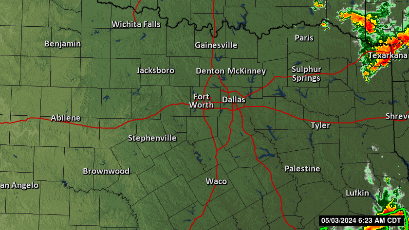
3 inches or so in Wichita Falls. Winding down, now. Will take a couple of days to return to normal as temperatures take their time rebounding
Posted on 2/3/22 at 10:09 am to wfallstiger
Pretty good band of snow moving over Fort Worth, and yeah it looks like it is almost over for Wichita Falls.
Posted on 2/3/22 at 10:13 am to NorthEndZone
Meanwhile, a tornado watch is fixing to be given for south Mississippi and central and SW Alabama.

Posted on 2/3/22 at 10:16 am to NorthEndZone
Friend in prosper sent me a video, nice snow right now

Posted on 2/3/22 at 10:27 am to NorthEndZone
Talked to my fiance this morning, lots of ice in Highland Park but no real snow. Looks like some is coming though
Posted on 2/3/22 at 10:31 am to H2O Tiger
Snow is coming down hard here in Fort Worth and has been for the past 2 hours
Posted on 2/3/22 at 10:35 am to goldennugget
yeah been coming down pretty good in DT FW for the last hour or so. was some sort of sleet/graupel BS when I left this morning.
Posted on 2/3/22 at 10:39 am to East Coast Band
Here's the forecast discussion from NWS Huntsville. There's a sneaky chance for severe weather for North AL, and a good chance for localized flooding.
ETA: Damn, I didn't realize they wrote so much.
quote:
000 FXUS64 KHUN 031538 AFDHUN
Area Forecast Discussion National Weather Service Huntsville AL 938 AM CST Thu Feb 3 2022
.NEAR TERM...(Rest of Today) Issued at 938 AM CST Thu Feb 3 2022
A positively tilted trough in the mid and upper levels remains in place over the Southeast as a shortwave trough over the Texas Panhandle tracks toward the Southeast today. At the surface, a slow moving cold front has pushed into the far northwest corner of Alabama. A surface low pressure system over the northwest Gulf of Mexico will track northeast along the cold front, strengthening southerly flow and warm moist air advection. This will pool south of the cold front, enhancing the threat for heavy rainfall. A southwesterly low level jet will overrun this warm, moist air mass, elongating curved hodographs in the warm sector. The lack of early morning rainfall will and lead to the development of surface- based instability, which is not being well-captured in model soundings. The long, skinny CAPE profile with shear vectors parallel to the cold front is a more typical flash flooding pattern for our area. Therefore, a flood watch remains in effect for all counties through midnight tonight. Most places will receive 1-2" of rain, but localized totals up to 4" are possible.
Sufficient instability with the impressive wind profiles and sickle- shaped hodographs make the severe potential difficult to disregard. While not the most favorable setup for severe weather, damaging wind gusts will be possible in stronger bands of rainfall as the front pushes through the area this afternoon and evening. A tornado or two can also not be ruled out, although this is a low threat. The best timing estimate is 2 PM to 7 PM for severe risk, but the flooding risk will persist throughout the day. I again want to emphasize that flooding is the primary threat to life today, and people should exercise caution if driving in low lying or flood prone areas.
Otherwise, the previous forecast remains on track with forecast high temperatures in the mid 60s for most areas. Far northwest Alabama already behind the front will see no risk for severe weather, and their high temperature has likely already occurred this morning in the low to mid 50s.
.SHORT TERM...(Tonight through Saturday) Issued at 228 AM CST Thu Feb 3 2022
The Arctic front and thunderstorm threat will shift into central and northeast AL early this evening, with rain ending in our northwest counties. There remains a risk of light rain and drizzle redevelopment behind the front as noted in forecast soundings. There may still be a narrow wind for a change to freezing rain or drizzle, mainly in the far western portions of north AL into southern middle TN. A Winter Weather Advisory may be needed if this indeed develops, but confidence remains a bit low at this time. Temperatures by morning will into the 30-32 range in these areas before climbing slowly on Friday morning. The low clouds will hamper this warming, with afternoon highs only in the middle 30s to upper 30s for most areas. After clearing takes place during the evening hours, temperatures will most certainly plummet into the lower 20s for most areas, and won`t rule out upper teens in southern TN and far northwest AL if it clears sooner.
The upper wave that has been progged to move across north AL on Saturday still does so, but with less amplification and divQ signal. Thus, precipitation looks very unlikely at this point given very dry low to mid levels. Highs will reach the lower to middle 40s as a result of ample sunshine. Dew points in the teens and north winds of 5-10 mph will make it feel several degrees colder.
.LONG TERM...(Saturday night through Wednesday) Issued at 228 AM CST Thu Feb 3 2022
The pressure gradient should relax even more Saturday night, as the center of the surface high shifts into the northeastern CONUS. Some scattered cloud cover may push into northeastern Alabama during that time from the east. With the mentioned cloud cover and as surface winds remain around 5 mph in most guidance, temperatures should stay at least a few degrees above dewpoints. Lows in the lower 20s west of I-65 and in the 25 to 30 degree range further east, looks reasonable.
During the day on Sunday a clipper system moves east across the Great Lakes region. With some weak low level easterly flow continuing in models, dewpoints and temperatures will increase slightly. This should result in highs reaching the upper 40s to lower 50s. A surface high re-establishes itself over eastern Texas northeast into the Ohio Valley behind it as well during this period. This should set the stage for ideal radiational cooling conditions Sunday night. With the slightly higher dewpoints expected, lows should only drop into the mid 20s to lower 30s.
This high continues to build east over the Mid-Atlantic region and southeastern states through the early portion of the day on Wednesday. This should make for a pretty steady state trend concerning temperatures. Highs in the upper 40s to lower 50s and lows in the 20s are expected during that period.
By Wednesday afternoon and evening, another clipper system drops southeast from the central Great Lakes region into the northeastern CONUS. This should begin to weaken the surface high over parts of the eastern CONUS. A weak dry frontal boundary stretching southwest from this looks to stall north of the area Thursday into Friday of next week. Westerly to southwesterly flow ahead of it will likely allow for some slightly warmer temperatures. Highs should climb back into the lower to mid 50s again as a result on Thursday. Lows will likely still remain in the upper 20s to lower 30s.
&&
.AVIATION...(For the 12Z TAFS through 12Z Friday morning) Issued at 437 AM CST Thu Feb 3 2022
LLWS will persist through 16-18Z with isolated to scattered SHRA possible. Ceilings will remain below 010agl through the period (IFR), possibly dropping below 005agl (LIFR) at times. A 1-3 hour period of +TSRA are expected from 17-20Z at KMSL and 20-23z at KHSV as a strong cold front pushes through. Brief gusts may exceed 35kt with the passage of the TS and cold front. Behind the frontal passage, a wind shift to the northwest is anticipated.
&&
.HUN WATCHES/WARNINGS/ADVISORIES... AL...Flood Watch through this evening for ALZ001>010-016.
TN...Flood Watch through this evening for TNZ076-096-097.
&&
$$
NEAR TERM...30 SHORT TERM...17 LONG TERM...KTW AVIATION...17
For more information please visit our website at weather.gov/huntsville.
ETA: Damn, I didn't realize they wrote so much.
This post was edited on 2/3/22 at 10:40 am

Posted on 2/3/22 at 10:43 am to H2O Tiger
quote:
fiance
quote:
Highland Park
subtle

Posted on 2/3/22 at 10:47 am to Dire Wolf
We’re getting off of work early. Why I’m not sure. Houston isn’t getting anything.

Posted on 2/3/22 at 10:49 am to NIH
In a thick Snowband now near Bush and the DNT

 Page 25 of 32

Popular
Back to top