- My Forums
- Tiger Rant
- LSU Recruiting
- SEC Rant
- Saints Talk
- Pelicans Talk
- More Sports Board
- Fantasy Sports
- Golf Board
- Soccer Board
- O-T Lounge
- Tech Board
- Home/Garden Board
- Outdoor Board
- Health/Fitness Board
- Movie/TV Board
- Book Board
- Music Board
- Political Talk
- Money Talk
- Fark Board
- Gaming Board
- Travel Board
- Food/Drink Board
- Ticket Exchange
- TD Help Board
Customize My Forums- View All Forums
- Show Left Links
- Topic Sort Options
- Trending Topics
- Recent Topics
- Active Topics
Started By
Message
re: SW LA getting rocked by severe storms this morning.
Posted on 5/18/21 at 9:24 pm to BallsEleven
Posted on 5/18/21 at 9:24 pm to BallsEleven
Weird I just got a text message from Entergy saying they detected a outage at my house and restore time is tomorrow by 2pm and 120 customers are affected …. But I haven’t lost power not even a flicker. Neighbor said he got same text message. Look at outage map and it shows my entire neighborhood is down, but everyone still has power..
 0
0

Posted on 5/18/21 at 9:24 pm to BOSCEAUX
Tornado warnings and lots of lightning starting in Houston tonight.
Posted on 5/18/21 at 9:28 pm to TXTIGERTAIL
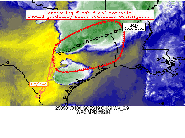
Mesoscale Precipitation Discussion 0204
NWS Weather Prediction Center College Park MD
911 PM EDT Tue May 18 2021
Areas affected...Parts of Southern and Southeast Texas
Concerning...Heavy rainfall...Flash flooding likely
Valid 190110Z - 190700Z
Summary...The risk of flash flooding will increase during the
evening over portions of southern and southeastern Texas this
evening...with the risk persisting beyond 07Z.
Discussion...There has been an increasing signal in the high
resolution convective-allowing models for flash flooding this
evening and into the overnight hours given persistent southeast
flow interacting with a quasi-stationary northeast-southwest
oriented boundary. 00Z soundings showed southerly low-level flow
of 20 to 30 kts drawing in an airmass with precipitable water
values in excess of 1.75 inches...resulting a moisture flux
convergence max along an outflow boundary/effective boundary over
southern and southeast Texas. MLCAPE values south of the effective
boundary had reached nearly 4000 J per kg during the time of
maximum heating during the afternoon...which allowed rainfall
rates to peak at 4 inches per hour in Fayette county Texas.
Because low level flow expected to increase to 30 kts or greater
at 850 mb during the evening, isolated rainfall rates of 2 to 3
inches per hour are still expected despite the loss of solar
heating.
The HRRR began consistently showing widespread areal-average
amounts of 2 to 4 inches...with isolated maximum values of 8+
inches...as early as its 18/20Z run. The experimental version of
the HRRR looked to be aligned with the NAM solution in placement
of its 2 and 3 inch per hour values, but those ideas were
verifying too far north and west as of early this evening.
Given some overlap between areas which received heavy rainfall in
the past 24 hour and the current placement shown by the guidance,
thinking is that flash flooding will become likely during the
evening and that the risk will extend beyond 07Z.
Bann
ATTN...WFO...CRP...EWX...FWD...HGX...LCH...SHV...
ATTN...RFC...WGRFC...NWC...
High instability supports some huge rainfall totals where you get some small scale stuff that enhances it, a la what appears to have happened in SEBR last night. Watch those areas that catch tornado warnings tonight, because they could well end up having some significant flood warnings a few hours later.
Posted on 5/18/21 at 9:30 pm to Duke
I'm not liking what most of the models are showing after those systems move across the TX/LA line. The first line throws on the brakes and waits for the second to catch up, then they head North/Northwest. We don't need that.
ETA: Not tonight. Tomorrow/tomorrow night.
ETA: Not tonight. Tomorrow/tomorrow night.
This post was edited on 5/18/21 at 9:32 pm

Posted on 5/18/21 at 9:30 pm to BallsEleven
This was close to Home Depot. I drove into Home Depot from the east this evening and saw the police removing the vehicle from the ditch. They had Prien completely closed just west of Home Depot. There were disabled vehicles all over in that area. That's a really busy area bordering I-210. Not sure how the car went unnoticed.
Posted on 5/18/21 at 9:31 pm to LegendInMyMind
quote:
I'm not liking what most of the models are showing after those systems move across the TX/LA line. The first line throws on the brakes and waits for the second to catch up, then they head North/Northwest.
It makes a lot of sense as the SE ridge starts to win the battle over the upper low in the west.

Posted on 5/18/21 at 9:31 pm to redstick13


Posted on 5/18/21 at 9:32 pm to TXTIGERTAIL
Katy under a Tornado Warning
Posted on 5/18/21 at 9:32 pm to Duke
quote:
It makes a lot of sense as the SE ridge starts to win the battle over the upper low in the west.
Weird to see, though. That would put a mess training over somewhere.
Posted on 5/18/21 at 9:34 pm to Gnash
quote:
Katy under a Tornado Warning
pretty damn bad here now… hearing large hail on the windows

This post was edited on 5/18/21 at 9:36 pm
Posted on 5/18/21 at 9:36 pm to bnb9433
quote:
pretty damn bad here now… hearing large hail on the windows
You've got some pretty good wind in that section of the line, too.

Posted on 5/18/21 at 9:38 pm to bnb9433
Damnit. I should have parked in the parking garage near me. I didn’t even think about hail. Hope we don’t get that in Kingwood.
Posted on 5/18/21 at 9:38 pm to LegendInMyMind
Hell of an outlow boundary forming, too.
Posted on 5/18/21 at 9:38 pm to bnb9433
That area near Richmond has to be seeing absurd rainfall rates currently. Katy too.
And hail in Katy really? It doesn't look like it on the radar, but I'm not going to argue ground truth.
ETA: Nvm. I see it now, but it's a small pocket.
And hail in Katy really? It doesn't look like it on the radar, but I'm not going to argue ground truth.
ETA: Nvm. I see it now, but it's a small pocket.
This post was edited on 5/18/21 at 9:39 pm
Posted on 5/18/21 at 9:40 pm to Duke
I’m in the Brookshire/Katy area… not hearing the hail anymore but it lasted for about 20 seconds
This post was edited on 5/18/21 at 9:41 pm
Posted on 5/18/21 at 9:41 pm to bnb9433
quote:
I’m in the Brookshire/Katy area… not hearing the hail anymore but it’s lasted for about 20 seconds
You south of I10?
Posted on 5/18/21 at 9:41 pm to Duke
Yes, about 2 miles
Posted on 5/18/21 at 9:46 pm to bnb9433
quote:
Yes, about 2 miles
Radar worked then, thats the pocket I saw.
Posted on 5/18/21 at 9:46 pm to Duke
That storm looks entirely different between the two radars in the area.
Posted on 5/18/21 at 9:48 pm to Aspercel
How’s your house Aspy? Sorry if I missed a post about it.

 Page 57 of 66

Popular
Back to top