- My Forums
- Tiger Rant
- LSU Recruiting
- SEC Rant
- Saints Talk
- Pelicans Talk
- More Sports Board
- Fantasy Sports
- Golf Board
- Soccer Board
- O-T Lounge
- Tech Board
- Home/Garden Board
- Outdoor Board
- Health/Fitness Board
- Movie/TV Board
- Book Board
- Music Board
- Political Talk
- Money Talk
- Fark Board
- Gaming Board
- Travel Board
- Food/Drink Board
- Ticket Exchange
- TD Help Board
Customize My Forums- View All Forums
- Show Left Links
- Topic Sort Options
- Trending Topics
- Recent Topics
- Active Topics
Started By
Message
re: Storm Watch- Gulf- Tropical Depression- Northward Miss. Valley
Posted on 6/3/20 at 11:28 pm to lovethetigers7

Posted on 6/3/20 at 11:28 pm to lovethetigers7
The OP needs to be updated
tsssk
tsssk
 0
0

Posted on 6/3/20 at 11:30 pm to lovethetigers7
quote:
I think 7 am? If not for sure 10 am
from the NHC?
1 AM... then 4 AM
This post was edited on 6/3/20 at 11:30 pm
Posted on 6/3/20 at 11:33 pm to rt3
1 am intermediate. No cone changes.
4 am full.
Looking at radar one more time before bed, looks like there's a slight S to SSW motion starting. May just be doing another loop but that direction would run him into rougher terrain.
4 am full.
Looking at radar one more time before bed, looks like there's a slight S to SSW motion starting. May just be doing another loop but that direction would run him into rougher terrain.
Posted on 6/3/20 at 11:57 pm to slackster
quote:
Today I also learned Fairbanks has the same population as New Iberia.
Yeah Alaska doesnt have much of a population center
Seriously though I thought it was the strangest thing up here, the weather.
Some of those folks that lives in the Aleitians essentially live in tropical force winds during the fall time.
The systems look like hurricanes too when they barrel into the west coast.
Posted on 6/4/20 at 12:11 am to gaetti15
Some of the finest baroclinic cyclones nature can offer in the Aleitians.
Posted on 6/4/20 at 12:14 am to gaetti15
quote:
Some of those folks that lives in the Aleitians essentially live in tropical force winds during the fall time.
In my first real job after college I worked with a guy who had been stationed on Shemya with the air force. He talked about the wind howling all the time. There were no trees and the only wildlife were burrowing rodents. There were some hiking trails along the beach but you had to beware of rogue waves. The only pastime was drinking. Anybody who wasn't an alcoholic became one. Guys would volunteer for Vietnam just to get away from there.
Posted on 6/4/20 at 1:10 am to Jim Rockford
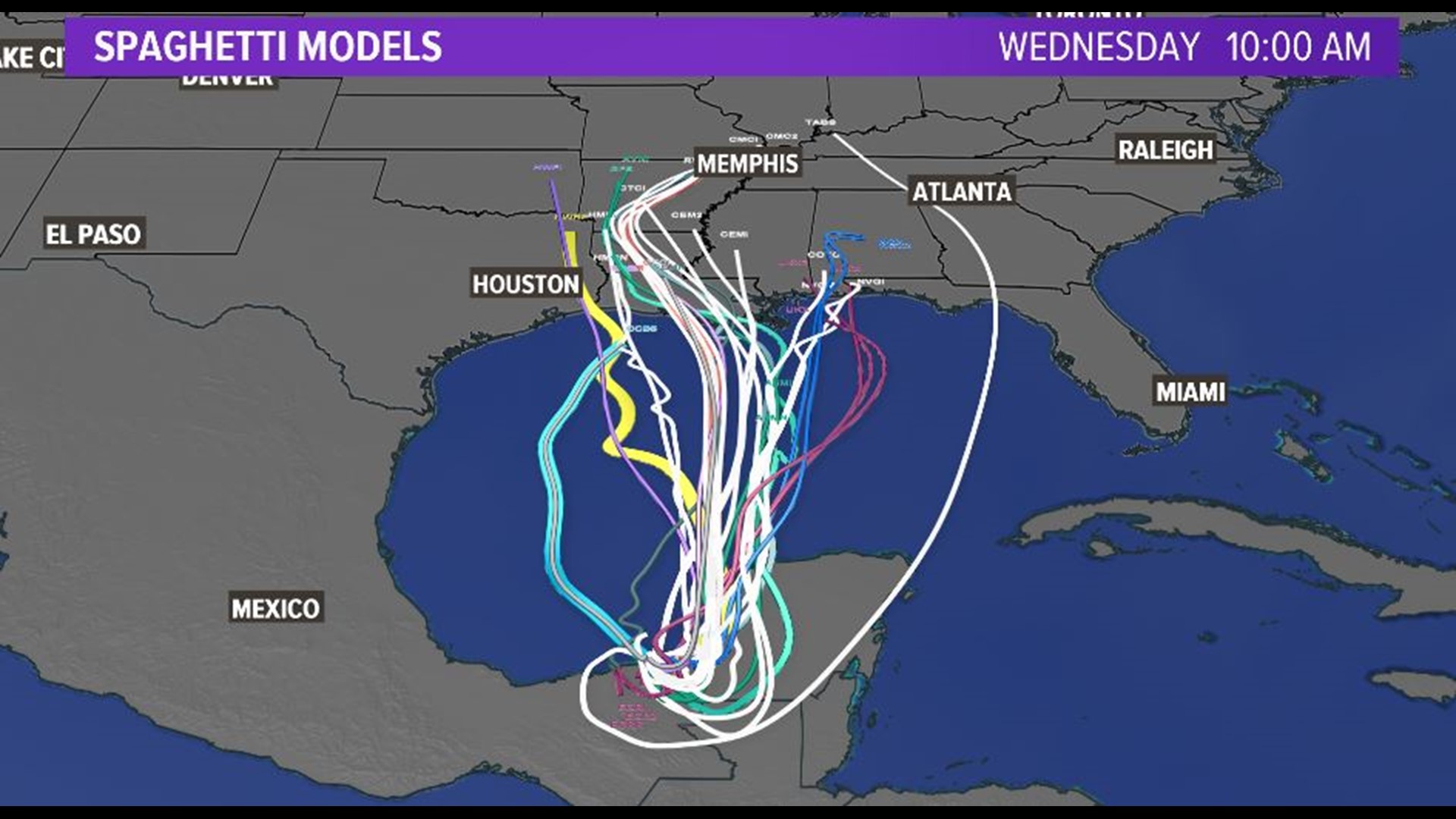
Late night Euro really trying to intensify this into a hurricane once in the central gulf.


Posted on 6/4/20 at 1:36 am to lsugolfredman
Also shifted a bit further east before hooking back west.


Posted on 6/4/20 at 5:45 am to whodatdude

Posted on 6/4/20 at 7:01 am to paperwasp
Did it stall or stay over land more than whtay was expected? I feel like it was supposed to hit our coast at some point on Sunday mid day and now it’s showing 1am on Monday

Posted on 6/4/20 at 7:09 am to GravelLotinCanada
quote:
Did it stall or stay over land more than whtay was expected? I feel like it was supposed to hit our coast at some point on Sunday mid day and now it’s showing 1am on Monday
I think it’s doing pretty much what’s been expected the last few days. The NHC cone had a 1am Monday landfall yesterday, too.
Posted on 6/4/20 at 7:13 am to Roll Tide Ravens
Wherever this thing makes landfall, I hope it moves out quickly. If we have a central Louisiana Coast landfall, I don’t want to see this thing meander around Louisiana and Arkansas for 3-4 days dumping a ton of rain on Louisiana, Arkansas, Mississippi and Alabama.
This post was edited on 6/4/20 at 7:14 am
Posted on 6/4/20 at 7:18 am to GravelLotinCanada
There is Definitely A shift in expected landfall. Sunday was the general thought and now it’s Early morning Monday.

Posted on 6/4/20 at 7:38 am to SlidellCajun
Euro brings max gusts to the southern half of the BR area in the range of 40-55 mph and sustained from 20-30 mph.
Posted on 6/4/20 at 8:34 am to SlidellCajun
quote:
There is Definitely A shift in expected landfall. Sunday was the general thought and now it’s Early morning Monday.
Like I said, they had the same landfall time on yesterday's cone.
Posted on 6/4/20 at 8:38 am to Roll Tide Ravens
Not liking the eastern trends. Hope they start shifting more West eventually taking that NW curve into Tx
Posted on 6/4/20 at 9:05 am to FelicianaTigerfan
Even if the BR area takes a direct hit from this, we're probably still just going to get rain and maybe a little wind. I know the EURO and some other models are showing max gusts close to 60mph but anyone who's ever been through a tropical storm or hurricane knows that the winds forecast almost never come to fruition - especially with tropical storms.
Posted on 6/4/20 at 9:06 am to FelicianaTigerfan
Well inland now and organization waning.
Going to be starting from practically scratch when back over the water.
Going to be starting from practically scratch when back over the water.
Posted on 6/4/20 at 9:07 am to TDsngumbo
quote:
Even if the BR area takes a direct hit from this, we're probably still just going to get rain and maybe a little wind. I know the EURO and some other models are showing max gusts close to 60mph but anyone who's ever been through a tropical storm or hurricane knows that the winds forecast almost never come to fruition - especially with tropical storms.
Many of these TS tend to have the worst rains away from the center. I'm worried about this thing hitting SE LA with a lot of rain. Hopefully it will be a quick mover and won't stall.

Posted on 6/4/20 at 9:21 am to LSUFanHouston
The models seem to be creeping East with some showing the kind of hook that could take it up the Mississippi. This thing does not have to be a Cat 3 to mess up New Orleans if it came in that way and dumped enough rain. Especially since the SWB does not have full power to the pumps.

 Page 32 of 107

Popular
Back to top