- My Forums
- Tiger Rant
- LSU Recruiting
- SEC Rant
- Saints Talk
- Pelicans Talk
- More Sports Board
- Fantasy Sports
- Golf Board
- Soccer Board
- O-T Lounge
- Tech Board
- Home/Garden Board
- Outdoor Board
- Health/Fitness Board
- Movie/TV Board
- Book Board
- Music Board
- Political Talk
- Money Talk
- Fark Board
- Gaming Board
- Travel Board
- Food/Drink Board
- Ticket Exchange
- TD Help Board
Customize My Forums- View All Forums
- Show Left Links
- Topic Sort Options
- Trending Topics
- Recent Topics
- Active Topics
Started By
Message
re: Storm Update:- Ida Moves Away - The Cleanup Begins...
Posted on 8/29/21 at 1:44 am to Sao

Posted on 8/29/21 at 1:44 am to Sao
LaToya tweeted about the new levee system
https://twitter.com/mayorcantrell
What do ya'll hear locally about this new levee system?
She also tweeted they said it would be a Cat4 at landfall.
https://twitter.com/mayorcantrell
What do ya'll hear locally about this new levee system?
She also tweeted they said it would be a Cat4 at landfall.
quote:
Mayor LaToya Cantrell Retweeted
NOLA Ready
@nolaready
·
4h
Impacts from Hurricane #Ida are expected to intensify throughout the morning. By midnight, everyone in New Orleans should shelter in place. Listen to your radio, television, or phone for updates. Text NOLAREADY to 77295 for emergency alerts. LINK
This post was edited on 8/29/21 at 1:47 am
 1
1


Posted on 8/29/21 at 1:44 am to FunkyFreshFranklin
Bro, like I told you earlier LEAVE.
Posted on 8/29/21 at 1:44 am to BigBro
quote:
Two hopes at this point.. IMO
(I am not a weather expert and my opinion is basically worthless.. but I’m going to give it anyways)
1) EWRC - Eyewall Replacement Cylce
She is getting so strong that a new bigger eye might try to form.. which will squeeze out the smaller eye. this would lower the max winds a little, but spread them out farther into the storm. Both are bad, but 145+
Don’t think an EWRC is in the cards for this one. It has shown zero signs of that and there isn’t much time left for that to happen but anythings possible. We need anything at this point to weaken it.

Posted on 8/29/21 at 1:45 am to Bayou_Tiger_225
quote:
People who went to bed at 10 are going to wake up wondering what the frick happened.
Worst case scenario is peolle wake up tomorrow and panic flee: and then gridlock traffic experiences a Cat 5 hurricane

Posted on 8/29/21 at 1:45 am to FunkyFreshFranklin
quote:
With two kids under 3, would you leave town or stay with nearby family who has new house and whole house generator in Metairie
If you can find a road to leave on.. I would get North asap.. that can haunt kids for life.

Posted on 8/29/21 at 1:46 am to Tigahs24Seven
quote:I live in the same area. In between BR and Prairieville. Will be riding it out here. Hoping for the best.
I am down the road Frim you by blue Bayou in Baton Rouge...

Posted on 8/29/21 at 1:46 am to TDsngumbo
quote:
It’s just that that euro run scared the living shite out of me.
But it was just a "run", right? Not set in stone that it is actually going to happen that way?

Posted on 8/29/21 at 1:46 am to UAinSOUTHAL
UAinSouthAL, You seem really educated and knowledgeable with this. Thank you so much 

Posted on 8/29/21 at 1:46 am to Jawilder
quote:
Sam Lillo
@splillo
Pressure in #Ida has dropped 40mb in the last 18 hours.
In the Atlantic there are 16 storms on record that have achieved this level of rapid deepening.
Most recently: Eta and Iota 2020, and Wilma and Rita 2005
Posted on 8/29/21 at 1:46 am to LSURoss
quote:
What fricking difference to a person on the ground is 5mph? This a fear porn post
Gonna be hot tomorrow. 96 forecasted, but could hit 97 and 99 is not out of possibility
You took the post the wrong way. Your right there isn’t much difference, I was commenting on what the NHC might do. The wind really isn’t the biggest threat anyway it’s the storm surge and flooding.
Posted on 8/29/21 at 1:47 am to Duke

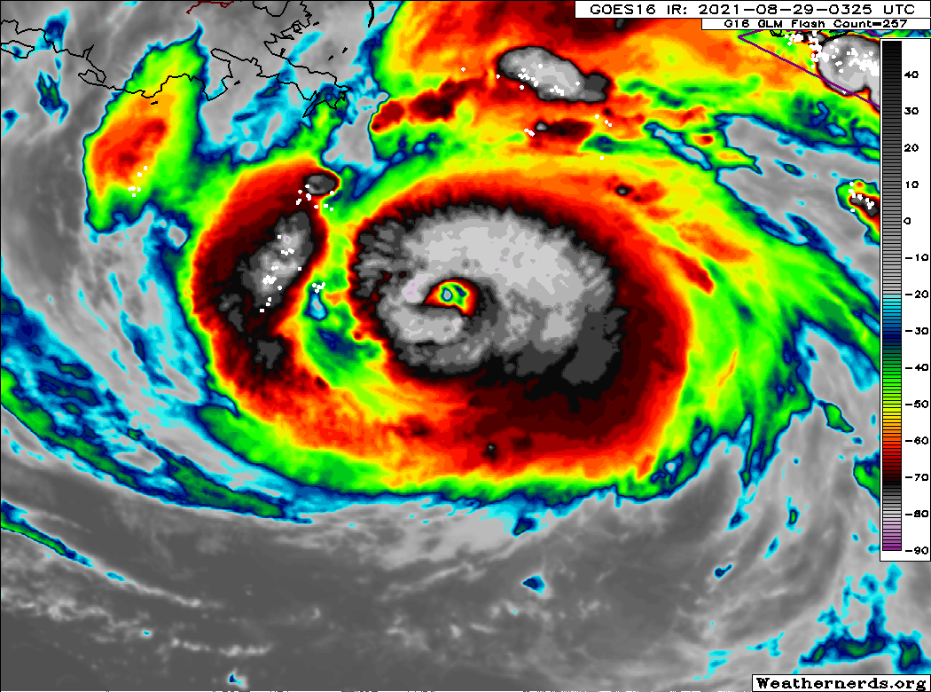
I keep looking for things to lift my spirits, and I just keep finding shite like this.
(This is dropsonde from the eye. There's a bunch of dry air sinking there, which is how eyes form. This sort of profile is what intense hurricanes start doing in the eye)
Posted on 8/29/21 at 1:47 am to BigBro
That lightning
This post was edited on 8/29/21 at 1:48 am

Posted on 8/29/21 at 1:47 am to RummelTiger
quote:
I know it's stretch, but if you wanna hop in a car and head to Austin, then you have a place to stay.
Can I come too? We can go to Stubbs.
Posted on 8/29/21 at 1:47 am to Duke
quote:
Looking at the water vapor...it didn't do much of that at all.
It is going to do something, but it won't be helpful. The moderate shear it brings will help offset the convection to the East. Those higher end rain totals are coming from that, I'm convinced. We will probably see bands dragged across as it lifts out.
The NAM having the placement of the heaviest rain closer to NOLA backs that up. It is a shitty situation even after landfall.
Posted on 8/29/21 at 1:48 am to cajunangelle
TD OT is much better that Latoya. Grassroots.
Posted on 8/29/21 at 1:48 am to GEAUXmedic
Classic Donut. Only the strongest storms get there..
Posted on 8/29/21 at 1:48 am to Duke
quote:
This is dropsonde from the eye. There's a bunch of dry air sinking there, which is how eyes form. This sort of profile is what intense hurricanes start doing in the eye
So what does that mean? Cat 5 incoming? Or what
Posted on 8/29/21 at 1:48 am to LegendInMyMind
OFFICIALLY A CAT 4
Posted on 8/29/21 at 1:48 am to LegendInMyMind
quote:
It is going to do something, but it won't be helpful. The moderate shear it brings will help offset the convection to the East. Those higher end rain totals are coming from that, I'm convinced. We will probably see bands dragged across as it lifts out.
No, what I wanted it to do it needed to do today and tonight.
The outflow I'm seeing says it ain't.

 Page 571 of 1029

Popular
Back to top