- My Forums
- Tiger Rant
- LSU Recruiting
- SEC Rant
- Saints Talk
- Pelicans Talk
- More Sports Board
- Coaching Changes
- Fantasy Sports
- Golf Board
- Soccer Board
- O-T Lounge
- Tech Board
- Home/Garden Board
- Outdoor Board
- Health/Fitness Board
- Movie/TV Board
- Book Board
- Music Board
- Political Talk
- Money Talk
- Fark Board
- Gaming Board
- Travel Board
- Food/Drink Board
- Ticket Exchange
- TD Help Board
Customize My Forums- View All Forums
- Show Left Links
- Topic Sort Options
- Trending Topics
- Recent Topics
- Active Topics
Started By
Message
re: Storm Update:- Ida Moves Away - The Cleanup Begins...
Posted on 8/27/21 at 7:52 pm to Roll Tide Ravens
Posted on 8/27/21 at 7:52 pm to Roll Tide Ravens
Almost to toledo from thibodaux.
Sorry I couldn't go through all the pages to get in touch with the baw to help board up his sister's windows.
Anyone have ah idea how far out thr wind fields gonna go?
Sorry I couldn't go through all the pages to get in touch with the baw to help board up his sister's windows.
Anyone have ah idea how far out thr wind fields gonna go?
 2
2


Posted on 8/27/21 at 7:52 pm to JDPndahizzy
quote:
If you’re in Iowa you should be fine
quote:
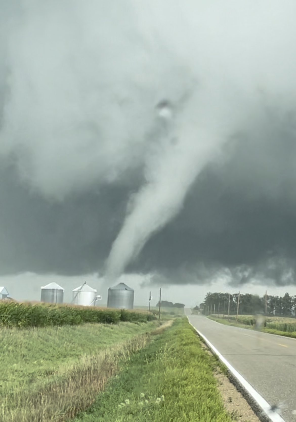
Willard Sharp - Storm Chaser & Photographer
@madridiowawx
Screen grab from the beautiful tornado that developed right in front of me earlier this afternoon several miles west of Maple Rock, Iowa. 2021 keeps on rolling for me. Captured some nice data using my @RadarOmega weather station. #iawx

Posted on 8/27/21 at 7:53 pm to Roll Tide Ravens
How fricked up will New Orleans and Slidell get here?
Posted on 8/27/21 at 7:53 pm to rmnldr
quote:
18z Euro with the HWRF with getting it under 940 mb.
For those keeping score at home, that's a 20mb drop in the 6hrs prior to landfall. Models are showing an environment conducive of RI all the way through landfall.

Posted on 8/27/21 at 7:54 pm to rds dc
quote:
For those keeping score at home, that's a 20mb drop in the 6hrs prior to landfall. Models are showing an environment conducive of RI all the way through landfall.
Sure hope this doesn't happen
Posted on 8/27/21 at 7:54 pm to GREENHEAD22
What you put in you summer gumbo baw
Posted on 8/27/21 at 7:54 pm to Duke
So what is the outlook for northern Lafayette Parish/St. Landry (basically immediately west of the current path) if the current path were to hold? From what I've seen on the models, looks like several inches of rain with 40 mph winds unless I'm misreading them.
NWS out of Lake Charles has a graphic saying 80-90 mph winds, but the only thing I've seen even remotely suggesting that is the probability graphics from NHC.
NWS out of Lake Charles has a graphic saying 80-90 mph winds, but the only thing I've seen even remotely suggesting that is the probability graphics from NHC.
This post was edited on 8/27/21 at 7:57 pm
Posted on 8/27/21 at 7:54 pm to DiamondDog
quote:
So..say you live East of LC by 10 miles. What should I expect with this storms current path?
On the Tropical Storm Warning posted on weather.com, the current forecast for this area is 15-20 mph, 25-30 gusts. It says the “potential” is there for hurricane force winds, but according to NHC, the chances of that happening is 13%.

Posted on 8/27/21 at 7:54 pm to rds dc
Apparently Jim Cantore checked into a Hampton inn in Laplace
Posted on 8/27/21 at 7:54 pm to TigerNAtux
quote:
But I’ve experienced sustained winds over 100mph for 10 straight hours.
When was this

Posted on 8/27/21 at 7:54 pm to DiamondDog
quote:
So..say you live East of LC by 10 miles. What should I expect with this storms current path?
An opportunity to cut your grass.
Posted on 8/27/21 at 7:54 pm to Macintosh
quote:.
see people keep saying there’s a slight shift East on the model yet these center lines keep shifting west. That center line was on western Houma a day or so ago. Hence my constant confusion lol
I think that is some of our OT weathermen running models beyond what the NHC is showing at present.
The NHC has shifted West steadily since 2 AM. About 35 miles from what I can see.
At 2 AM it was at Hwy 90 and 182 near Houma. Now further West.
This post was edited on 8/27/21 at 7:56 pm

Posted on 8/27/21 at 7:56 pm to Duzz
quote:
How fricked up will New Orleans and Slidell get here?

Posted on 8/27/21 at 7:56 pm to rds dc
quote:
For those keeping score at home, that's a 20mb drop in the 6hrs prior to landfall. Models are showing an environment conducive of RI all the way through landfall.
With the global (well a global model I suppose) models picking up on such rapid deepening too, it's screaming to be ready for a power hurricane rapidly intensifying on approach.
Which you know, isn't something I'd be super keen to ride out.

Posted on 8/27/21 at 7:57 pm to rds dc
quote:
Models are showing an environment conducive of RI all the way through landfall.
How much more can Ida honestly strengthen in comparison to what a model like the HWRF is already forecasting prior to landfall? The models are ready terrible looking as is.

Posted on 8/27/21 at 7:57 pm to maisweh
I don’t know specifics but from what I just was told in the phone, far

Posted on 8/27/21 at 7:58 pm to Duke
Is the track pretty much set in stone or is it continuing to shift?

Posted on 8/27/21 at 7:58 pm to TackySweater
Rapid Intensification
Posted on 8/27/21 at 7:58 pm to BigBrod81
You done fricked up A ARON!!!

 Page 302 of 1029

Popular
Back to top