- My Forums
- Tiger Rant
- LSU Recruiting
- SEC Rant
- Saints Talk
- Pelicans Talk
- More Sports Board
- Fantasy Sports
- Golf Board
- Soccer Board
- O-T Lounge
- Tech Board
- Home/Garden Board
- Outdoor Board
- Health/Fitness Board
- Movie/TV Board
- Book Board
- Music Board
- Political Talk
- Money Talk
- Fark Board
- Gaming Board
- Travel Board
- Food/Drink Board
- Ticket Exchange
- TD Help Board
Customize My Forums- View All Forums
- Show Left Links
- Topic Sort Options
- Trending Topics
- Recent Topics
- Active Topics
Started By
Message
 0
0

Posted on 8/27/21 at 9:53 am to LSUTiger23
the weather app I use has this thing landing between LC and Lafayette and it was spot on last year's hurricanes
Posted on 8/27/21 at 9:53 am to rds dc
another question is does a stronger storm than expected get more influenced by the ridge and causing a path more along the lines of the more westward models

Posted on 8/27/21 at 9:53 am to sp22
quote:
they got 90-100 from Laura
Sustained or Gust?
Posted on 8/27/21 at 9:54 am to ellesssuuu
quote:
the weather app I use has this thing landing between LC and Lafayette and it was spot on last year's hurricanes
Was it spot on 3 days before landfall or 12 hours before landfall?
I’m going bet my paycheck 12 hours before landfall

Posted on 8/27/21 at 9:54 am to LSUTiger23

BR folk better wake up


Posted on 8/27/21 at 9:54 am to ellesssuuu
quote:
the weather app I use
Found your issue

Posted on 8/27/21 at 9:55 am to Tigerfan1274
quote:
Man, those two western tracks come right up to Lafayette.
I’m prepping for the western eye wall of a CAT 3. We’ll see.

Posted on 8/27/21 at 9:55 am to GeorgeTheGreek
quote:
All this sounds fun until you don’t have power for 10 days.
How about on Day 4, you're still walking in the kitchen with the hand motion reflex towards the light switch to turn it on, chuckle and say you dummy, you know damn well that shite is still off
Posted on 8/27/21 at 9:55 am to DhanTigers212
I see like 2 lines east and a bunch by marsh island....
Not sure what to think or wishcast
Not sure what to think or wishcast

Posted on 8/27/21 at 9:55 am to LSUfanNkaty
We're all one big happy family here.
Except for the wishing the storm on each other and not themselves.
Except for the wishing the storm on each other and not themselves.
Posted on 8/27/21 at 9:56 am to lsusteve1
I believe sustained, there were multiple week power outages
Posted on 8/27/21 at 9:56 am to LSUfanNkaty
What are the chances JBE Mentions a Mandatory Evacaution at his presser this afternoon?
Im trying to get out of BR and head to the beach first thing in the morning, hope i can beat i12 traffic.
A mandatory evacuation would def jam me up.
Im trying to get out of BR and head to the beach first thing in the morning, hope i can beat i12 traffic.
A mandatory evacuation would def jam me up.

Posted on 8/27/21 at 9:56 am to DhanTigers212
The Baton Rouge area is about to get frickED UP

Posted on 8/27/21 at 9:57 am to sp22
Getting closer to Lafayette. Frick.
Posted on 8/27/21 at 9:57 am to Jwho77
quote:
We're all one big happy family here.
Except for the wishing the storm on each other and not themselves

Posted on 8/27/21 at 9:57 am to LSUfanNkaty
Experts - do you foresee any eastern shifts?
Posted on 8/27/21 at 9:57 am to DhanTigers212
That does not look good

Posted on 8/27/21 at 9:58 am to LSUfanNkaty
Woke up to see it shifted a little and is now too uncomfortably close to Lake Charles. Don't like that at all.
Posted on 8/27/21 at 9:58 am to TDsngumbo
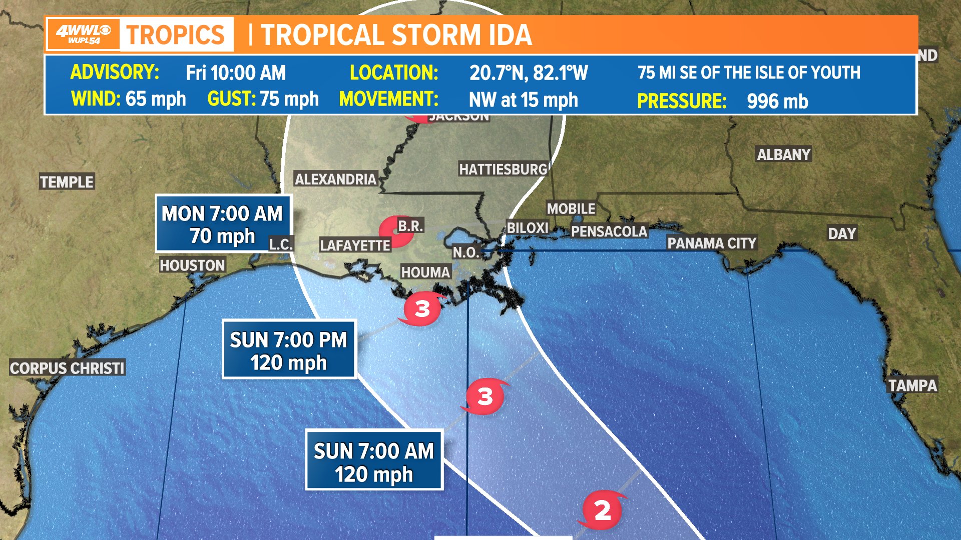
000
WTNT44 KNHC 271449
TCDAT4
Tropical Storm Ida Discussion Number 5
NWS National Hurricane Center Miami FL AL092021
1100 AM EDT Fri Aug 27 2021
Radar imagery from Grand Cayman and Cuba as well as satellite data
continue to show an improvement in Ida's overall structure this
morning, with an increase in banding, the development of a small
central dense overcast, and more recently an improved inner-core
feature. Both the NOAA and Air Force reconnaissance aircraft
reported that the pressure has fallen to around 996 mb, and the Air
Force plane has measured flight-level and SFMR winds that support
an initial intensity of 55 kt.
Although there is still some southwesterly shear over Ida, the
outflow has begun to expand over the northeastern and southeastern
portions of the circulation. The upper-level trough near the
Yucatan peninsula that has been imparting the shear over Ida is
forecast to weaken and move westward during the next 12 to 24
hours, which should result in a more favorable upper-level
wind pattern. This, in combination with warm sea surface
temperatures and a moist environment along the forecast track of
the storm are expected to result in steady to rapid strengthening.
Ida is now foreast to become a hurricane when it is near western
Cuba and once it moves over the southeastern Gulf of Mexico a period
of rapid strengthening is likely to begin, with the NHC intensity
forecast explicitly calling for rapid intensification to major
hurricane strength between 24 and 48 hours. The official intensity
forecast is on the higher side of the intensity guidance but not
quite as high as the slightly more aggressive CTCI, HWRF, and HCCA
models. In addition to the increase in strength, the dynamical
model guidance indicates that Ida's wind field will grow larger as
it moves over the Gulf of Mexico and this is reflected in the NHC
wind radii forecast. In summary, there is a higher-than-normal
confidence that a significant hurricane will impact a large portion
of the northern Gulf coast by late this weekend and early next week.
Ida is moving northwestward or 320/13 kt. The track forecast
reasoning is unchanged from before. A mid-level ridge over the
western Atlantic is forecast to move westward and this should keep
Ida on a general northwestward heading during the next 48-60 hours.
This track will bring the storm across western Cuba later today,
over the southeastern and central Gulf of Mexico on Saturday and
Saturday night, to the coast of Louisiana by late Sunday. The
track guidance is in remarkably good agreement with very little
cross-track spread during the first 60 hours or so of the forecast
period. After that time, Ida is forecast to reach the western
portion of the ridge, which is expected to cause the storm to slow
down and turn northward and then northeastward over the
southeastern United States. The NHC track forecast is near or
just east of the various consensus aids, in best agreement with the
GFS ensemble mean. Although the small spread in the guidance
through landfall increases the overall confidence in the track
forecast, users are reminded to not focus on the exact details of
the forecast track as storm surge, wind, and rainfall impacts will
extend far from the center.
Key Messages:
1. Life-threatening storm surge and hurricane conditions are
expected later today and tonight in portions of western Cuba,
including the Isle of Youth, where a Hurricane Warning is in effect.
Life-threatening heavy rains, flash flooding and mudslides are
expected across Jamaica, the Cayman Islands, and western Cuba,
including the Isle of Youth.
2. The risk of life-threatening storm surge inundation is increasing
along the coasts of Louisiana, Mississippi, and Alabama. Inundation
of 7 to 11 feet above ground level is possible within the area from
Morgan City, Louisiana, to Ocean Springs, Mississippi, including
Lake Borgne. Interests in these areas should follow any advice given
by local officials.
3. Ida is expected to be a dangerous major hurricane when it reaches
the northern Gulf Coast on Sunday, and the risk of hurricane-force
winds continues to increase, especially along portions of the
Louisiana coast, including metropolitan New Orleans. Potentially
devastating wind damage could occur where the core of Ida moves
onshore.
4. Ida is likely to produce heavy rainfall later Sunday into Monday
across the central Gulf Coast from southeast Louisiana to coastal
Mississippi and Alabama, as well as the Lower Mississippi Valley,
resulting in considerable flash, urban, small stream, and riverine
flooding.
FORECAST POSITIONS AND MAX WINDS
INIT 27/1500Z 20.7N 82.1W 55 KT 65 MPH
12H 28/0000Z 22.2N 83.7W 65 KT 75 MPH...OVER WESTERN CUBA
24H 28/1200Z 24.0N 85.8W 75 KT 85 MPH...OVER WATER
36H 29/0000Z 25.9N 87.8W 90 KT 105 MPH
48H 29/1200Z 27.6N 89.7W 105 KT 120 MPH
60H 30/0000Z 29.0N 90.8W 105 KT 120 MPH
72H 30/1200Z 30.3N 91.3W 60 KT 70 MPH...INLAND
96H 31/1200Z 33.3N 90.2W 30 KT 35 MPH...INLAND
120H 01/1200Z 35.2N 87.1W 20 KT 25 MPH...POST-TROP/REMNT LOW
$$
Forecaster Brown
this storm staying at 120mph for 12 hours over the gulf feels extremely unlikely

 Page 195 of 1029

Popular
Back to top