- My Forums
- Tiger Rant
- LSU Recruiting
- SEC Rant
- Saints Talk
- Pelicans Talk
- More Sports Board
- Fantasy Sports
- Golf Board
- Soccer Board
- O-T Lounge
- Tech Board
- Home/Garden Board
- Outdoor Board
- Health/Fitness Board
- Movie/TV Board
- Book Board
- Music Board
- Political Talk
- Money Talk
- Fark Board
- Gaming Board
- Travel Board
- Food/Drink Board
- Ticket Exchange
- TD Help Board
Customize My Forums- View All Forums
- Show Left Links
- Topic Sort Options
- Trending Topics
- Recent Topics
- Active Topics
Started By
Message
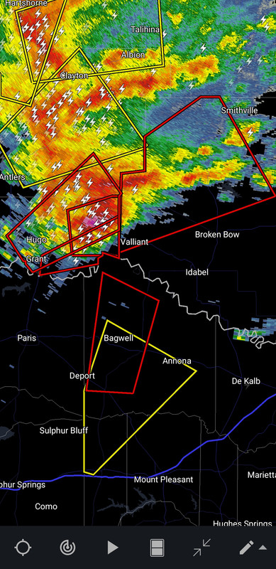
re: Southern Severe Weather Threat (Thursday/Friday)
Posted on 3/2/23 at 5:41 pm to LegendInMyMind
Posted on 3/2/23 at 5:41 pm to LegendInMyMind

 1
1

Posted on 3/2/23 at 5:41 pm to 50_Tiger
Quick tip for judging winds in a thunderstorm, especially QLCS storms.
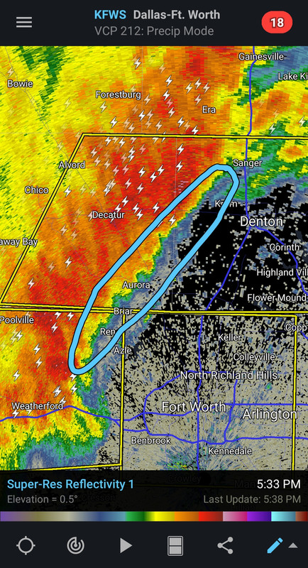
See how there is very little green on the leading edge of the part I circled? Strong winds are pushing the heavier precip in the direction the storm is moving. When that green thins out or goes away, that's all you need to know that big winds are coming.
See how there is very little green on the leading edge of the part I circled? Strong winds are pushing the heavier precip in the direction the storm is moving. When that green thins out or goes away, that's all you need to know that big winds are coming.
Posted on 3/2/23 at 5:43 pm to LegendInMyMind
I'd watch the spot near Krum right now for a chance that rotation could form.
Posted on 3/2/23 at 5:44 pm to 50_Tiger
thank goodness I no longer have to worry about the CenLA storms
now I have to worry about the metro NOLA storms again
now I have to worry about the metro NOLA storms again
Posted on 3/2/23 at 5:44 pm to Bobby OG Johnson
quote:
Alex Spahn
@spahn711
I just found an area east of Sherman, TX where the hail was waist deep. How do I know that's how deep it is? I slid into it and the hail was up to my waist. I'm cold. #txwx

Twitter video
Whoa! That's a pile of hail
Posted on 3/2/23 at 5:45 pm to LegendInMyMind
That's what weather peopleses call a "mess of polygons".
Posted on 3/2/23 at 5:46 pm to LegendInMyMind

Umm why no warning?
Posted on 3/2/23 at 5:46 pm to LegendInMyMind
My knees are aching. Gonna be a bad 'un tonight.
Posted on 3/2/23 at 5:47 pm to Bobby OG Johnson
If that wasn't dem Alex Spahn......I don't know that I would believe it. There was a storm in Colorado a year or so ago that did something similar.
Posted on 3/2/23 at 5:50 pm to LegendInMyMind
quote:
If that wasn't dem Alex Spahn......I don't know that I would believe it. There was a storm in Colorado a year or so ago that did something similar.
I had to watch the video to fully believe it

Posted on 3/2/23 at 5:53 pm to Bobby OG Johnson
quote:
RadarOmega
@RadarOmega
·
7s
OBSERVED Tornado Warning including Shreveport LA, Bossier City LA, and Red Chute LA until 6:30 PM CST. SEEK SHELTER! #LAwx
SOURCE: Weather spotters confirmed tornado. At 5:40PM CST, a tornado was spotted in Southeast Shreveport.

Posted on 3/2/23 at 5:54 pm to Bobby OG Johnson
Observed tornado in Shreveport. It's in a radar blind spot right now though
Posted on 3/2/23 at 5:54 pm to Bobby OG Johnson
Stay safe baws
Posted on 3/2/23 at 5:56 pm to LegendInMyMind
It’s really calm here which is wild. Im 30 minutes east of Denton which has ~70mph winds.
Eerie.
Eerie.

Posted on 3/2/23 at 5:58 pm to Bobby OG Johnson
The National Weather Service in Shreveport has issued a
* Tornado Warning for... West central Webster Parish in northwestern Louisiana... Central Caddo Parish in northwestern Louisiana... Central Bossier Parish in northwestern Louisiana...
* Until 630 PM CST.
* At 549 PM CST, a confirmed tornado was located over Fosters, or over Bossier City, moving north at 30 mph.
HAZARD...Damaging tornado.
SOURCE...Weather spotters confirmed tornado. At 540 PM CST, a tornado was spotted in Southeast Shreveport.
IMPACT...Flying debris will be dangerous to those caught without shelter. Mobile homes will be damaged or destroyed. Damage to roofs, windows, and vehicles will occur. Tree damage is likely.
* The tornado will be near... Eastwood around 605 PM CST.
Other locations impacted by this tornadic thunderstorm include Rocky Mount, Ferguson, Princeton, Fillmore, Linton, Bodcau, Bellevue, Barksdale Air Force Base, Ivan and Sligo.
Posted on 3/2/23 at 5:59 pm to Bobby OG Johnson
quote:
Spotter Network Inc
@spotternetwork
·
49s
Spotr 3 miles NNE of BLUE MOUND, TX @ 23:58 UTC Wind (80mph) [M]>-Significant shingle damage to roofing, power flashes, signs damaged. North Riverside and Tarrant Parkway.
Posted on 3/2/23 at 6:00 pm to Bobby OG Johnson
Posted on 3/2/23 at 6:01 pm to Bobby OG Johnson
LINK
Video of debris in the air at LSUS. Also just saw a picture of a funnel in the area on local news. Will link it if it pops up online.
Video of debris in the air at LSUS. Also just saw a picture of a funnel in the area on local news. Will link it if it pops up online.

 Page 23 of 34

Popular
Back to top