- My Forums
- Tiger Rant
- LSU Recruiting
- SEC Rant
- Saints Talk
- Pelicans Talk
- More Sports Board
- Coaching Changes
- Fantasy Sports
- Golf Board
- Soccer Board
- O-T Lounge
- Tech Board
- Home/Garden Board
- Outdoor Board
- Health/Fitness Board
- Movie/TV Board
- Book Board
- Music Board
- Political Talk
- Money Talk
- Fark Board
- Gaming Board
- Travel Board
- Food/Drink Board
- Ticket Exchange
- TD Help Board
Customize My Forums- View All Forums
- Show Left Links
- Topic Sort Options
- Trending Topics
- Recent Topics
- Active Topics
Started By
Message
re: Southeast Severe Weather: January 8-9, 2024
Posted on 1/8/24 at 8:31 pm to Roll Tide Ravens

Posted on 1/8/24 at 8:31 pm to Roll Tide Ravens

 1
1

Posted on 1/8/24 at 8:32 pm to Roll Tide Ravens

Posted on 1/8/24 at 8:35 pm to Roll Tide Ravens
Never trust a warm front.
Also, its probably gonna be the QLCS based tors that are the severe pain in the arse tonight. That and it'll be a windbag some places.
Also, its probably gonna be the QLCS based tors that are the severe pain in the arse tonight. That and it'll be a windbag some places.
Posted on 1/8/24 at 8:37 pm to The Boat
quote:
Pre-frontal instability was going to be tough to come by, limiting pre-frontal severe weather as we saw. Just enough of a cap today. Thought the lack of widespread rain might help boost instability but we didn’t see that.
Yeah, I think had we seen that warm front lift earlier it may have had just enough forcing to get some storms to fire. We got the relatively clear air going into the night like was modeled, but nothing to overcome the cap. I think it is shaping up for a rough time in Mobile later.
This post was edited on 1/8/24 at 8:38 pm

Posted on 1/8/24 at 8:37 pm to Roll Tide Ravens
With quite a few severe events recently we’re seeing people so focused on the off the charts kinematics that they forget about the thermodynamics. It’s always going to be a delicate balance in the winter time. Big difference between winter and spring severe weather. You can’t blindly follow the CAMs but when hrrr et all are consistently showing a limited severe outbreak over most of LA you need to step back and dig into that with a little more detail. This is about Louisiana, not Mississippi and Alabama.
Posted on 1/8/24 at 8:39 pm to Duke
Lot of dry air at the mid levels behind the line for the rest of the night that will entrain and ramp up the downdrafts. Bet we see a wall of wind reports along the coast late tonight.
Posted on 1/8/24 at 8:39 pm to The Boat
That's like the sounding earlier that got people excited. Yeah....crazy shear and srh, but CAPE was pitiful, especially low level, and moisture lagged the models.
Posted on 1/8/24 at 8:39 pm to The Boat
Heck of a storm system.

Posted on 1/8/24 at 8:43 pm to Roll Tide Ravens
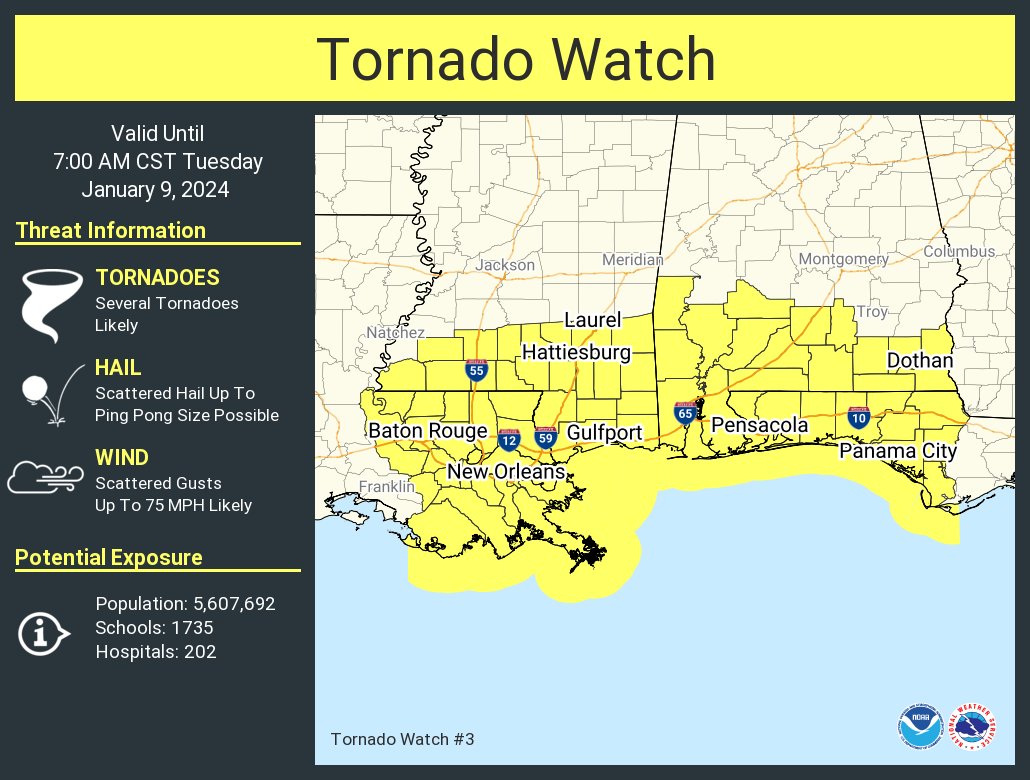
And the new watch is out.

This post was edited on 1/8/24 at 8:45 pm
Posted on 1/8/24 at 8:44 pm to Roll Tide Ravens
New tornado watch:
Posted on 1/8/24 at 8:47 pm to shoelessjoe
quote:
Not sure if it was mentioned but they think they had a tornado hit in Labadieville in Assumption parish. Messed up the fire station and a few businesses next to it. Plus a mobile home.
Assumption Parish is a low key tornado hot spot in south LA. There’s always one going through there season after season.

Posted on 1/8/24 at 8:48 pm to Roll Tide Ravens
Ain’t shite happening out here currently, reporting live, Waffle news….

Posted on 1/8/24 at 8:50 pm to Impotent Waffle
MS is getting some serious rain

Posted on 1/8/24 at 8:50 pm to The Boat
I saw the storm report and said “yea this checks out” hopefully everyone’s alright knew an old coonie from Labadieville. He was a good dude.
Posted on 1/8/24 at 8:51 pm to Impotent Waffle
So this was a warm front but it’s gonna be colder tomorrow? Is this El Niño?
Posted on 1/8/24 at 8:57 pm to Roll Tide Ravens
quote:
LINK
Through 7am?
That is going to make for a dicey call on having school tomorrow. I would imagine busses rolling at 5:45 tomorrow morning, and being on the road for an hour, is something that school systems will have to consider.
Crazy stuff.
Posted on 1/8/24 at 8:57 pm to OysterPoBoy
Mid-latitude cyclone, brotato sauce
Warm front moves through then the cold front follows. The squall line moving through is basically the cold front.

Warm front moves through then the cold front follows. The squall line moving through is basically the cold front.
Posted on 1/8/24 at 9:00 pm to jimmy the leg
quote:
Through 7am?
That is going to make for a dicey call on having school tomorrow.
Not anywhere in Louisiana. The line will be through Pensacola by 7 am.
Posted on 1/8/24 at 9:01 pm to Roll Tide Ravens
I've always found it odd how storms all seem to dissipate near Baton Rouge. I suspected it was the chemical plants but never looked it up until now.
Research reveals how air pollution can stop rainfall
Research reveals how air pollution can stop rainfall
Posted on 1/8/24 at 9:02 pm to The Boat
Many schools in the Mobile and Panhandle area have already made the call to delay or cancel tomorrow.

 Page 26 of 36

Popular
Back to top