- My Forums
- Tiger Rant
- LSU Recruiting
- SEC Rant
- Saints Talk
- Pelicans Talk
- More Sports Board
- Coaching Changes
- Fantasy Sports
- Golf Board
- Soccer Board
- O-T Lounge
- Tech Board
- Home/Garden Board
- Outdoor Board
- Health/Fitness Board
- Movie/TV Board
- Book Board
- Music Board
- Political Talk
- Money Talk
- Fark Board
- Gaming Board
- Travel Board
- Food/Drink Board
- Ticket Exchange
- TD Help Board
Customize My Forums- View All Forums
- Show Left Links
- Topic Sort Options
- Trending Topics
- Recent Topics
- Active Topics
Started By
Message
 1
1


Posted on 3/13/25 at 6:29 am to MOT
quote:
This is going to be one of those days where some baws say “this wuz a big miss nothing even happened” because a tornado doesn’t roll directly through their yard, while something 20 miles away gets completely smashed.
Exactly.
We had a devastating tornado hit us years ago. We fared somewhat in the middle of how our entire street was hit. On one end of the street a couple of houses were half blown away, we suffered a bunch of trees that fell on the house, and at the other end of the street narry a leaf was lifted from a tree.
And this street is less than a half mile long.
Posted on 3/13/25 at 6:31 am to MOT

Getting 10s now on the Significant Tornado Parameter scale for Saturday.
Posted on 3/13/25 at 6:33 am to Old Man and a Porch
quote:
What time should we be looking for this around the Baton Rouge area Saturday?
Jared Silverman for WAFB thinks from 10 AM to 2 PM is BR’s worst if anything occurs, while New Orleans under the gun til 4-5 PM
Posted on 3/13/25 at 6:41 am to schwartzy
After reading the SPC outlook for Saturday, model guidance is tending to not show rain and convection Saturday morning, which is favoring more instability for Saturday afternoon. Supercells are believed to form in southern Mississippi in advance of the cold front. This one looks like it could be a scary day for Mississippi moreso than central Alabama during the day and early evening, but west Alabama also should be keeping an eye on the skies. Birmingham might not get much until after sundown
Somewhere in our usual list of tornado suspects around Hattiesburg will likely see something. Also very rare to have New Orleans city limits under a moderate risk
Somewhere in our usual list of tornado suspects around Hattiesburg will likely see something. Also very rare to have New Orleans city limits under a moderate risk
This post was edited on 3/13/25 at 6:55 am
Posted on 3/13/25 at 6:43 am to MOT
quote:
This is going to be one of those days where some baws say “this wuz a big miss nothing even happened” because a tornado doesn’t roll directly through their yard, while something 20 miles away gets completely smashed.
Yeah, sorry, I'm not being like that. Mostly just personally annoyed that the geniuses in NOLA cancelled Saturdays parade before the higher-accuracy models were available to confirm the risk in that area or timeframe.

Posted on 3/13/25 at 7:18 am to jmcwhrter
The logistics involved do not allow waiting for high-res models to come in range, I'd imagine.
Posted on 3/13/25 at 7:34 am to BottomlandBrew
quote:
The logistics involved do not allow waiting for high-res models to come in range, I'd imagine.
All good, I'll get over it. Hope it passes as a mild rain event and I'll keep my grumbling to myself

Posted on 3/13/25 at 7:44 am to East Coast Band
First MDT of the season?
This post was edited on 3/13/25 at 7:45 am
Posted on 3/13/25 at 7:54 am to slackster
That’s a bad day for the entire landmass.
Posted on 3/13/25 at 8:19 am to tide06
shite - Delta, better keep your head on a swivel man.
hell all you MS guys be safe
hell all you MS guys be safe
Posted on 3/13/25 at 8:37 am to slackster
Saturday is going to be a very bad day

Posted on 3/13/25 at 9:08 am to deltaland
quote:
Saturday is going to be a very bad day
I’m afraid so. Hopefully there will be a fly in the ointment that causes this event to bust. Right now, though, I think we’re looking at a pretty substantial tornado outbreak. Not an April 27, 2011 level outbreak, because those only tend to happen once every 30-40 years, but still a significant event that will produce a significant number of tornadoes (a few of which will likely be of the strong, long-track variety).
SPC isn’t allowed to issue a high risk beyond the day 2 outlook. I expect that sometime tomorrow afternoon or tomorrow night, they will add a high risk area for Saturday.
This post was edited on 3/13/25 at 9:17 am
Posted on 3/13/25 at 9:13 am to East Coast Band
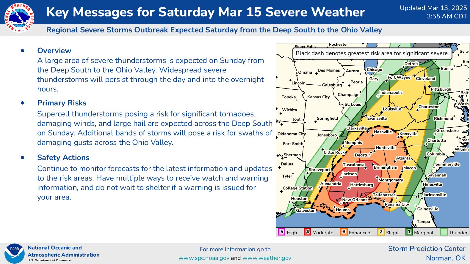
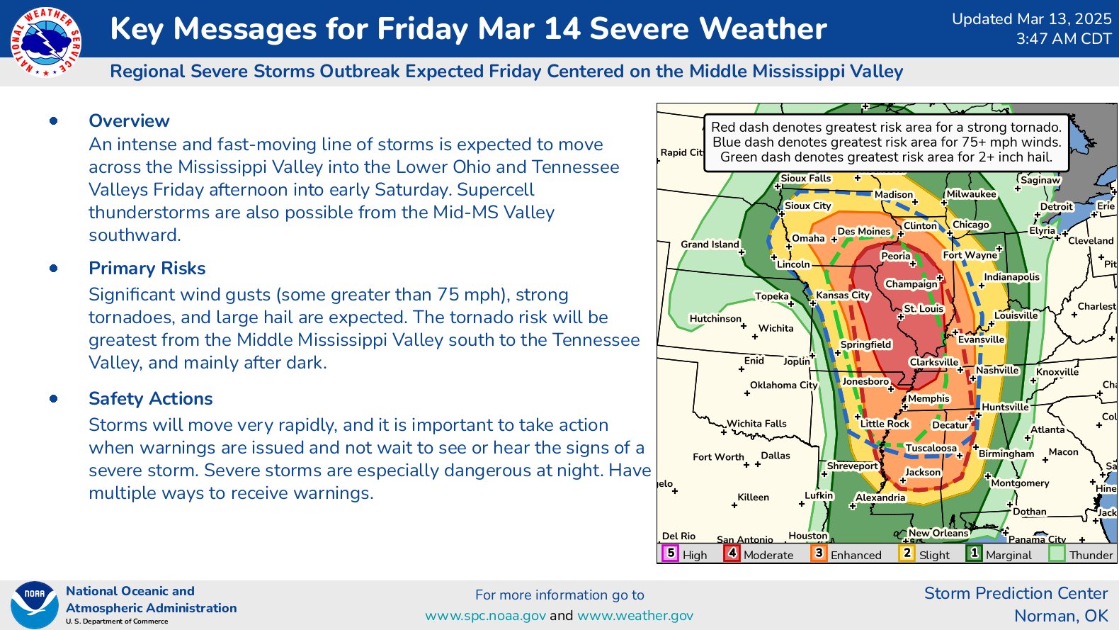
Here are graphics from a few of the local NWS offices in the region regarding the Saturday round of severe weather:
NWS Birmingham, AL:

NWS New Orleans/Baton Rouge, LA:

NWS Jackson, MS:
NWS Huntsville, AL:
(These graphics should update automatically here when those NWS offices update them.)
NWS Birmingham, AL:
NWS New Orleans/Baton Rouge, LA:
NWS Jackson, MS:
NWS Huntsville, AL:
(These graphics should update automatically here when those NWS offices update them.)
This post was edited on 3/13/25 at 9:17 am
Posted on 3/13/25 at 9:59 am to Roll Tide Ravens
If that occurred I woudk expect that to include Hattiesburg, Meridian, and parts of west Alabama mainly
Posted on 3/13/25 at 10:02 am to deltaland
quote:
Saturday is going to be a very bad day
I've got the same feeling.

Posted on 3/13/25 at 10:09 am to Lg
Same. I've got family in a lot of the hot spots. Hattiesburg, Montgomery, Birmingham, Huntsville.
I was in Tuscaloosa on 4/27/11 and was in Hattiesburg for multiple large tornados in that area. I don't wish that on anyone
I was in Tuscaloosa on 4/27/11 and was in Hattiesburg for multiple large tornados in that area. I don't wish that on anyone
Posted on 3/13/25 at 10:13 am to LegendInMyMind
quote:
The reality? 4/27/2011 was a perfect setup. There were no flies in the ointment. That said, it doesnt take that type of setup to make for a very bad day
One thing about 4/27/2011 that I don't think gets talked about enough is how there were two rounds that day AND in just a matter of 4-6 hours the atmosphere was primed enough it was able to recover to have optimal tornadic conditions
That just doesn't happen very often
Posted on 3/13/25 at 10:17 am to Wishnitwas1998
quote:
One thing about 4/27/2011 that I don't think gets talked about enough is how there were two rounds that day AND in just a matter of 4-6 hours the atmosphere was primed enough it was able to recover to have optimal tornadic conditions
I was still in high school when it happened. We had that terrible line of storms early that morning. Five people died in Alabama from the morning storms and over a quarter million people in Alabama had no power after the morning round. For some reason my school system didn’t cancel and instead we went to school just to be released before lunch. Anyway, I remember being in my 1st period class that morning and looking out the window around 8:00 or 8:30 and the sun was shining brightly. I knew then that the afternoon round was still on. Of course, I still didn’t imagine it would be as horrific as it turned out to be.

 Page 10 of 21

Popular
Back to top