- My Forums
- Tiger Rant
- LSU Recruiting
- SEC Rant
- Saints Talk
- Pelicans Talk
- More Sports Board
- Fantasy Sports
- Golf Board
- Soccer Board
- O-T Lounge
- Tech Board
- Home/Garden Board
- Outdoor Board
- Health/Fitness Board
- Movie/TV Board
- Book Board
- Music Board
- Political Talk
- Money Talk
- Fark Board
- Gaming Board
- Travel Board
- Food/Drink Board
- Ticket Exchange
- TD Help Board
Customize My Forums- View All Forums
- Show Left Links
- Topic Sort Options
- Trending Topics
- Recent Topics
- Active Topics
Started By
Message
re: Sally - Moving towards Georgia - Potential for Significant Flooding
Posted on 9/15/20 at 5:33 pm to SlidellCajun
Posted on 9/15/20 at 5:33 pm to SlidellCajun
It's one storm. I'd say it is a bit of an overeaction.
 0
0


Posted on 9/15/20 at 5:37 pm to SlidellCajun
Go to bed boomer . You’re too old for dumb knee jerk reactions over 1 storm.
Posted on 9/15/20 at 5:38 pm to Duke
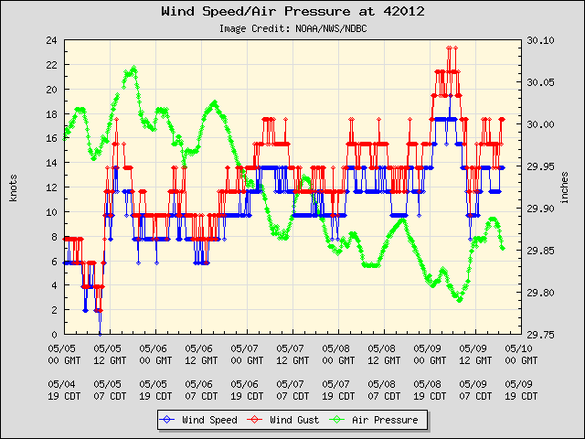
50 miles from center of Sally and South of Orange Beach buoy pressure dropping out...

Posted on 9/15/20 at 5:39 pm to The Boat
quote:
when you get hours and hours up to days of that wind speed it’s like LSU’s offensive line in 2011 pounding and pounding away in the 1st half. Then by the 4th quarter the other teams given up and they start getting bulldozed and fall over.
So that means we can blame Jordan Jefferson for stalling Sally.

Posted on 9/15/20 at 5:46 pm to SlidellCajun
quote:
I’m just incredibly disappointed in the 56 hour prediction accuracy of this thing
Y’all are hilarious with this stuff.
If this thing was projected to the TX/LA border but hit Morgan City 2.5 days later, no one would be nearly as stupefied. Same state, no biggie, even if it’s a bigger miss (165 miles). But let a storm be projected for New Orleans and then move over a couple of 50 mile wide states and people Act like the NHC is just throwing shite st the dartboard.
Do y’all want bigger cones and more false alarms, because this is how you get them.
In the 1970s the NHC missed, on average, by over 460 miles 72 hours out. They didn’t even try to give predictions 4 and 5 days out.
Posted on 9/15/20 at 5:50 pm to slackster
Tonight at 10 Mother Nature is not 100% predictable and does what she wants.
Posted on 9/15/20 at 5:56 pm to The Boat
quote:
withstand that but when you get hours and hours up to days of that wind speed it’s like LSU’s offensive line in 2011 pounding and pounding away in the 1st half. Then by the 4th quarter the other teams given up and they start getting bulldozed and fall over.
If this hurricane is 2011 LSU then the state of Alabama has nothing to worry about

Posted on 9/15/20 at 6:00 pm to deltaland
Posted on 9/15/20 at 6:08 pm to SlidellCajun
Rainfall total at Mobile ( KMOB) since midnight to 6:00 CDT. =. 1.25 inches.
Recent peak wind 49 knots ( 57 mph) past hour.
Recent peak wind 49 knots ( 57 mph) past hour.
This post was edited on 9/15/20 at 6:08 pm

Posted on 9/15/20 at 6:09 pm to The Boat
quote:
It’s gonna be a long 24 hours along the coast. Those aren’t incredibly strong winds and they’re not going to be incredibly strong. Buildings, trees, and power lines can withstand that but when you get hours and hours up to days of that wind speed it’s like LSU’s offensive line in 2011 pounding and pounding away in the 1st half. Then by the 4th quarter the other teams given up and they start getting bulldozed and fall over.
Did you copy and paste this from the Laura thread?
Posted on 9/15/20 at 6:13 pm to Klingler7
Rainfall on Ft Morgan Rd 7" with plenty more to come
Posted on 9/15/20 at 6:14 pm to TH03
quote:
Did you copy and paste this from the Laura thread?
I doubt it since Laura was an air raid offense of a storm.
Posted on 9/15/20 at 6:14 pm to NorthEndZone
HWRF drops Sally to 972 millibars in the next few hours before landfall

HMON is very similar

HMON is very similar
This post was edited on 9/15/20 at 6:16 pm
Posted on 9/15/20 at 6:17 pm to Klingler7
I drove down Perdido Beach Blvd a couple of hours ago. Water standing on beach side lanes in front of the Phoenix buildings in Orange Beach. Just a low area though, didn’t see flooding. Visibility is pretty poor outside my condo in Phoenix V. Wind pretty continuous and waves are pretty huge and lots of white caps. Waves coming up to the bases of the sea dunes. Pretty chilly outside with the lower temperatures and wind. Can stand on my balcony on the 11th floor without any wind resistance, but I do get a lot of mist from the sideways rain.
Posted on 9/15/20 at 6:17 pm to NorthEndZone
Believable.

Posted on 9/15/20 at 6:20 pm to Duke
Recon is almost there it should be interesting to see what they find pressure wise.
Posted on 9/15/20 at 6:22 pm to NorthEndZone
quote:
HWRF drops Sally to 972 millibars in the next few hours before landfall
What does this mean exactly? Thanks for your posts!
Posted on 9/15/20 at 6:22 pm to Duke
He made the exact same LSU OLine comparison in that thread. 
Posted on 9/15/20 at 6:23 pm to antibarner
quote:
Recon is almost there it should be interesting to see what they find pressure wise.
Probably going to miss the pass, heading back to NOLA here in a few.
Figure maybe mb or two drop though. This is a pretty interesting scenario (well for the data, not if you're in the way of the storm) where the planes are close by and they get to make a bunch of passes.
quote:
He made the exact same LSU OLine comparison in that thread
I'm not renowned for my memory.
This post was edited on 9/15/20 at 6:24 pm

 Page 210 of 298

Popular
Back to top