- My Forums
- Tiger Rant
- LSU Recruiting
- SEC Rant
- Saints Talk
- Pelicans Talk
- More Sports Board
- Fantasy Sports
- Golf Board
- Soccer Board
- O-T Lounge
- Tech Board
- Home/Garden Board
- Outdoor Board
- Health/Fitness Board
- Movie/TV Board
- Book Board
- Music Board
- Political Talk
- Money Talk
- Fark Board
- Gaming Board
- Travel Board
- Food/Drink Board
- Ticket Exchange
- TD Help Board
Customize My Forums- View All Forums
- Show Left Links
- Topic Sort Options
- Trending Topics
- Recent Topics
- Active Topics
Started By
Message
re: New Year’s Day Severe Weather Thread - Enhanced Risk in AL, TN, MS, AR
Posted on 1/1/22 at 3:30 pm to LegendInMyMind

Posted on 1/1/22 at 3:30 pm to LegendInMyMind
Surprised they’ve never issued a tornado warning on that one.
 2
2

Posted on 1/1/22 at 3:32 pm to Roll Tide Ravens
I just don't think it was there as far as a tight rotation goes. That's legit wind going through the Shoals right now, though. I bet they're getting some 70mph+ gusts.
Posted on 1/1/22 at 3:38 pm to LegendInMyMind
quote:
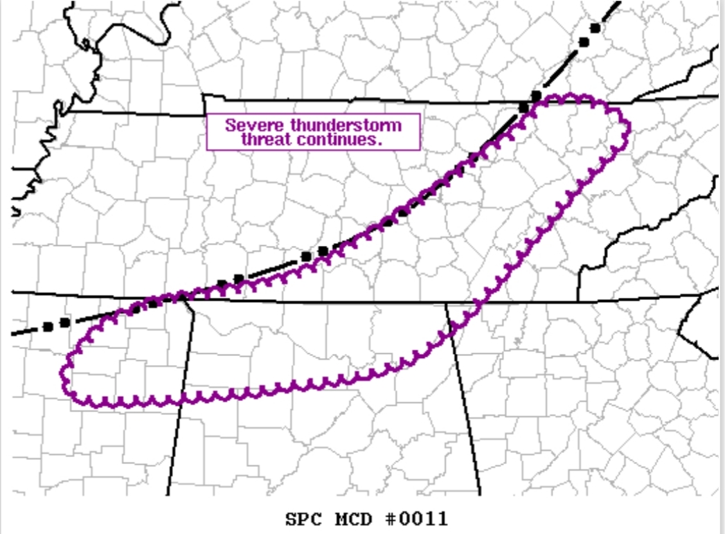
Mesoscale Discussion 0011 NWS Storm Prediction Center Norman OK 0327 PM CST Sat Jan 01 2022
Areas affected...North/Northeast MS...Northern AL...Middle TN
Concerning...Tornado Watch 3...4...5...
Valid 012127Z - 012300Z
The severe weather threat for Tornado Watch 3, 4, 5 continues.
SUMMARY...Severe thunderstorm threat, including the potential for a tornado, continues ahead of the outflow boundary from northeast MS across northern AL into middle TN.
DISCUSSION...Despite an abundance of warm sector development, most of this activity has failed to materialize into supercells thus far. The only exception is the pair of northeastward moving supercells, one over far north-central MS and the other over far northwest AL. Westernmost cell in this pair has begun to interact with the outflow while the easternmost cell is still slightly ahead of the boundary and may be able to remain more intense for a bit longer.
While some weakening of the buoyancy has occurred, this narrow corridor ahead of the outflow still represents the best area for potential severe thunderstorms for the next few hours.
..Mosier.. 01/01/2022
...Please see www.spc.noaa.gov for graphic product...
ATTN...WFO...MRX...JKL...FFC...OHX...BMX...HUN...MEG...
LAT...LON 34198907 34468923 34908862 35268692 36278503 36618444 36408378 35908433 34668581 34348721 34198907
As Duke would say, there's a chance for the mesoscale to do something with the outflow boundary. Otherwise, the cap is still in place.
Wind has calmed and shifted more out of the SW instead of due South. That's actually favorable for strengthening rotation, though.
This post was edited on 1/1/22 at 3:43 pm
Posted on 1/1/22 at 3:39 pm to LegendInMyMind
LOL rolled 28k posts in a Severe Weather thread man - grats, i guess
looks like it is gonna be real interesting the next few hours
looks like it is gonna be real interesting the next few hours

Posted on 1/1/22 at 3:40 pm to Roll Tide Ravens
quote:
Surprised they’ve never issued a tornado warning on that one.
I mean that cell ENE of Belmont sure looks like a warning is warranted. Velocity and hook on radar look no bueno in my amateur opinion.
Guess that's why they let the pros handle it.
Posted on 1/1/22 at 3:45 pm to tgrgrd00
And the latest sounding from UAH shows the cap still in place.
NWS Huntsville also mentioned the wind shift.
NWS Huntsville also mentioned the wind shift.
Posted on 1/1/22 at 3:47 pm to LegendInMyMind
SPC also mentioned that the cap was holding firm in the mesoscale discussion they issued a little while ago.
quote:
SUMMARY...Severe thunderstorm threat, including the potential for a
tornado, continues ahead of the outflow boundary from northeast MS
across northern AL into middle TN.
DISCUSSION...Despite an abundance of warm sector development, most
of this activity has failed to materialize into supercells thus far.
The only exception is the pair of northeastward moving supercells,
one over far north-central MS and the other over far northwest AL.
Westernmost cell in this pair has begun to interact with the outflow
while the easternmost cell is still slightly ahead of the boundary
and may be able to remain more intense for a bit longer.
While some weakening of the buoyancy has occurred, this narrow
corridor ahead of the outflow still represents the best area for
potential severe thunderstorms for the next few hours.
Posted on 1/1/22 at 3:53 pm to Roll Tide Ravens
Getting late in the day to break the cap via surface heating mixing.
Posted on 1/1/22 at 3:57 pm to Duke
I saw some folks whining that SPC didn't go MOD for today. This, imo, is why they didn't.

Posted on 1/1/22 at 4:17 pm to LegendInMyMind

Posted on 1/1/22 at 4:19 pm to JoeHackett
And here we go
Posted on 1/1/22 at 4:22 pm to auwaterfowler
May have a TDS west of Elkton, TN. Need another scan to tell for sure.
Posted on 1/1/22 at 4:23 pm to auwaterfowler
Reed Timmer left the Pulaski area and then an hour later they issue a warning. 
Posted on 1/1/22 at 4:23 pm to Roll Tide Ravens
Definitely looks like a TDS.
Posted on 1/1/22 at 4:25 pm to Roll Tide Ravens
Yep. It was brief, though.
That rotation, as it is right now and has been for a couple hours now, isn't going to produce a long running tornado.
That rotation, as it is right now and has been for a couple hours now, isn't going to produce a long running tornado.
This post was edited on 1/1/22 at 4:28 pm
Posted on 1/1/22 at 4:28 pm to LegendInMyMind
Confirmed tornado per NWS Nashville.
Posted on 1/1/22 at 4:30 pm to Roll Tide Ravens
In Elkton or Nashville area?
Posted on 1/1/22 at 4:32 pm to Roll Tide Ravens
quote:
Confirmed tornado per NWS Nashville.
Hell they've dropped the warning already.
This post was edited on 1/1/22 at 4:33 pm
Posted on 1/1/22 at 4:37 pm to LegendInMyMind
quote:
Hell they've dropped the warning already.
Yeah, that was weird. Didn’t extend the warning or anything, even though 5 minutes earlier the warning update said confirmed tornado.

 Page 5 of 12

Popular
Back to top