- My Forums
- Tiger Rant
- LSU Recruiting
- SEC Rant
- Saints Talk
- Pelicans Talk
- More Sports Board
- Fantasy Sports
- Golf Board
- Soccer Board
- O-T Lounge
- Tech Board
- Home/Garden Board
- Outdoor Board
- Health/Fitness Board
- Movie/TV Board
- Book Board
- Music Board
- Political Talk
- Money Talk
- Fark Board
- Gaming Board
- Travel Board
- Food/Drink Board
- Ticket Exchange
- TD Help Board
Customize My Forums- View All Forums
- Show Left Links
- Topic Sort Options
- Trending Topics
- Recent Topics
- Active Topics
Started By
Message
re: New Year’s Day Severe Weather Thread - Enhanced Risk in AL, TN, MS, AR
Posted on 1/1/22 at 1:19 pm to LegendInMyMind
Posted on 1/1/22 at 1:19 pm to LegendInMyMind
First lighting on the storm SW of Pontotoc, MS.
Tishomingo storm that is crossing the MS/AL line is looking better.
Tishomingo storm that is crossing the MS/AL line is looking better.
 1
1


Posted on 1/1/22 at 1:19 pm to LegendInMyMind
So who else is sitting outside on their covered porch in shorts, T-shirt, and flip flops waiting for the 48° temperature drop? Is already down 10° in the last hour
This post was edited on 1/1/22 at 1:21 pm
Posted on 1/1/22 at 1:22 pm to calcotron
My first time hearing the horns in Brentwood…Scared the crap out me…not used to weather sirens…Thought China was attacking….AGAIN

Posted on 1/1/22 at 1:25 pm to BestBanker
Storms are firing across MS and west AL.

Posted on 1/1/22 at 1:27 pm to Roll Tide Ravens
From James Spann (for the central AL area). Addresses the current cap in place.
quote:
EARLY AFTERNOON UPDATE: NWS Birmingham launched a special balloon at midday (normally we only get a sounding at 6am and 6pm daily), and the data still shows a layer of warmer air aloft.
Seems as if the weak "cap" aloft is being eroded and gradually breached in spots. Showers continue to develop over the northern half of the state... the showers are shallow due to the residual capping aloft, they are producing no lightning as of 1:15p CT. Will be watching to see if showers can break through and modify/erode the drier/warmer environment and grow taller. Hasn't happened yet.
Still no change in thinking concerning timing, threats, etc. Just stay weather aware and pay attention to warnings if they are needed. A tornado watch remains in effect for parts of the Tennessee Valley of far North Alabama.
This post was edited on 1/1/22 at 1:30 pm
Posted on 1/1/22 at 1:36 pm to LegendInMyMind

Posted on 1/1/22 at 1:42 pm to Roll Tide Ravens
77°/67° on my front porch. Intermittent blue skies and sun.
This post was edited on 1/1/22 at 1:42 pm
Posted on 1/1/22 at 1:44 pm to LegendInMyMind
quote:
77°/67° on my front porch. Intermittent blue skies and sun.
Same for me. Don’t like it.
Posted on 1/1/22 at 1:49 pm to Roll Tide Ravens
Convection over north MS is awfully messy

Posted on 1/1/22 at 1:53 pm to Wishnitwas1998
So is this something that will get worse throughout the night or is this the peak time for development?
I’m a complete noob when it comes to shite like this.
I’m a complete noob when it comes to shite like this.
Posted on 1/1/22 at 1:58 pm to tilco
quote:
So is this something that will get worse throughout the night or is this the peak time for development?
I’m a complete noob when it comes to shite like this.
If we continue to see destabilization via heating and dew points rising into the evening hours we could see a continuing threat.
A strong low level jet will get stronger into the early evening hours. The big question is if the cap that is in place right now holds.
Generally, you watch for those small cells to grow in size and height, and watch for an increase in lightning. If you start to see that, and it continues, you know the cap is eroding.
Worth noting is that pretty much everything is rotating today, just like yesterday in North GA when rain showers put down tornadoes.
This post was edited on 1/1/22 at 2:02 pm
Posted on 1/1/22 at 2:03 pm to LegendInMyMind
Maybe someone can answer this. Is there anything that will help hold the cap and keep it from eroding away? Local meteorologists say that they see the cap eroding some soon and I know everyone has been saying as long as cap holds that will limit
Posted on 1/1/22 at 2:07 pm to NEALCD
quote:
Maybe someone can answer this. Is there anything that will help hold the cap and keep it from eroding away? Local meteorologists say that they see the cap eroding some soon and I know everyone has been saying as long as cap holds that will limit
It is really just a race against daytime heating and when/where storms form in relation to the strongest capping inversion. Enough energy and instability will allow any individual storm to grow vertically and break the cap. You'll start to see those updrafts grow and the rotation will follow.

Posted on 1/1/22 at 2:12 pm to Roll Tide Ravens
Wind is insane in Knoxville today.
Posted on 1/1/22 at 2:13 pm to Roll Tide Ravens
How is it looking for extreme NE AL? I am on Sand Mountain and just went walking and it’s sunny, windy and 81 degrees. Just bad “feel” about it.
This post was edited on 1/1/22 at 2:14 pm
Posted on 1/1/22 at 2:13 pm to LegendInMyMind

Mesoscale Discussion 0009
NWS Storm Prediction Center Norman OK
0157 PM CST Sat Jan 01 2022
Areas affected...Northern MS into Far Northern AL and Southern
Middle TN.
Concerning...Tornado Watch 3...4...5...
Valid 011957Z - 012130Z
The severe weather threat for Tornado Watch 3, 4, 5 continues.
SUMMARY...Development of a few discrete supercells capable of
producing tornadoes and damaging wind gusts possible from northern
MS into far northern AL and southern middle TN.
DISCUSSION...Recent observations suggest the outflow boundary moving
through western TN has become less defined near the TN/MS border,
suggesting that much of warm sector across northern MS and adjacent
northern AL/southern middle TN will likely stay free from the
influence of this boundary. Additionally, the amount and intensity
of the warm sector cells has continued to increase, with several
cells producing lightning over the past hour. This development is
occurring within an environment characterized by warm and moist
low-levels and strong vertical shear. Recent GWX VAD also sampled
300 m2/s2 of 0-1 km storm-relative helicity. Expectation is for the
storms currently in northern MS to organize/intensify further as
they continue northeastward into a more sheared downstream
environment.
Posted on 1/1/22 at 2:19 pm to weadjust
@NWSHuntsville
quote:
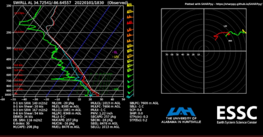
[2:15 PM]: UAH sounding from 12:30 PM indicates warm air around 600 mb. This is keeping the storms in check for now but this warm air will erode throughout the afternoon/evening leading to better instability & chances for svr storms. #HUNwx LINK
This post was edited on 1/1/22 at 2:22 pm
Posted on 1/1/22 at 2:29 pm to LegendInMyMind
not liking how this is shaping up today - got a weird feeling about it
Posted on 1/1/22 at 2:55 pm to Thracken13
@NWSHuntsville
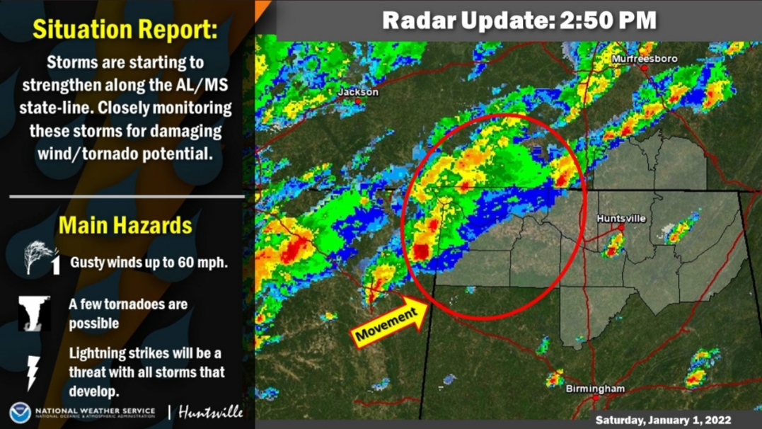
quote:
[2:50 PM}: Storms are starting to strengthen along the AL/MS state-line. One of the storms has just become severe and expect storms will continue to move into a favorable environment for severe storms this afternoon/evening. #HUNwx LINK
Posted on 1/1/22 at 2:57 pm to LegendInMyMind
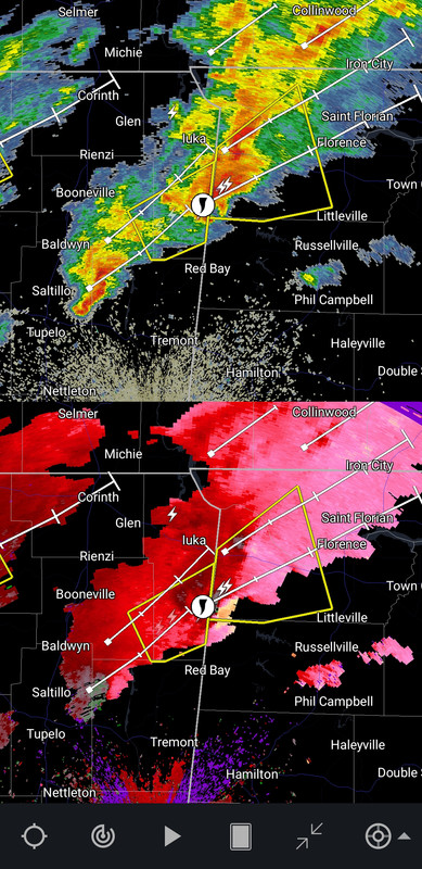
Concern is picking up for the Shoals area. Those storms are ramping up. Tornado or not, some high winds are heading their way.
This post was edited on 1/1/22 at 2:58 pm

 Page 4 of 12

Popular
Back to top