- My Forums
- Tiger Rant
- LSU Recruiting
- SEC Rant
- Saints Talk
- Pelicans Talk
- More Sports Board
- Fantasy Sports
- Golf Board
- Soccer Board
- O-T Lounge
- Tech Board
- Home/Garden Board
- Outdoor Board
- Health/Fitness Board
- Movie/TV Board
- Book Board
- Music Board
- Political Talk
- Money Talk
- Fark Board
- Gaming Board
- Travel Board
- Food/Drink Board
- Ticket Exchange
- TD Help Board
Customize My Forums- View All Forums
- Show Left Links
- Topic Sort Options
- Trending Topics
- Recent Topics
- Active Topics
Started By
Message
re: New Year’s Day Severe Weather Thread - Enhanced Risk in AL, TN, MS, AR
Posted on 1/1/22 at 4:40 pm to Roll Tide Ravens

Posted on 1/1/22 at 4:40 pm to Roll Tide Ravens
Surprised this storm east of Tishomingo that just crossed into AL isn’t tornado warned.
 1
1

Posted on 1/1/22 at 4:43 pm to Roll Tide Ravens
I think the low level winds are really dicking with the shear and due to storm motion nothing has really been able to wrap up. No storm on the Southern mode has had that classic look to it today.
Posted on 1/1/22 at 4:46 pm to LegendInMyMind
Yeah, the rotation looks messy now. Decent inflow notch, but couplet doesn’t look great.

Posted on 1/1/22 at 4:49 pm to LegendInMyMind
I’m no expert but I’ll remain on alert in Huntsville for a bit more.
Tri-cities,Limestone county Alabama and Giles county Tennessee seem to have been a path today.
Still more in Mississippi to come but nightfall might quell some of those.
Thanks so much OT.
Tri-cities,Limestone county Alabama and Giles county Tennessee seem to have been a path today.
Still more in Mississippi to come but nightfall might quell some of those.
Thanks so much OT.

Posted on 1/1/22 at 5:31 pm to footswitch

Posted on 1/1/22 at 5:35 pm to JoeHackett
Crazy how a storm that doesn’t look strong and has very little lightning is able to produce pretty strong rotation.
Posted on 1/1/22 at 5:37 pm to Roll Tide Ravens
quote:
Crazy how a storm that doesn’t look strong and has very little lightning is able to produce pretty strong rotation.
I'm telling you, the tornadoes in Georgia yesterday came from damn rain showers.
Now, that said, the Starkville storm is a bit more worrisome going forward because it is finally being influenced by the front. The storm motion is a little different which may allow it to tighten up that circulation and maintain it.
This post was edited on 1/1/22 at 5:40 pm
Posted on 1/1/22 at 5:42 pm to LegendInMyMind

Posted on 1/1/22 at 5:44 pm to JoeHackett

Posted on 1/1/22 at 5:45 pm to JoeHackett
Things seems to be getting more active. Thunderstorm warnings all over and now two Tornado warning.s
Posted on 1/1/22 at 5:49 pm to Roll Tide Ravens
Yea I almost posted that I would have never expected a warning to come from there just based on reflectivity
Posted on 1/1/22 at 5:52 pm to Wishnitwas1998
Notice the difference in storm motion compared to what we've seen all day. There's more of an Eastern component to them, which coupled with the shift of the surface winds earlier, is giving is a more favorable shear pattern.
This is why you will see NWS offices more willing to warn those broader circulations than they were earlier today.
This is why you will see NWS offices more willing to warn those broader circulations than they were earlier today.
Posted on 1/1/22 at 5:53 pm to LegendInMyMind
@NWSHuntsville
quote:
[5:50 PM]: UAH sounding from 4:30 PM still indicates warm air aloft at 600 mb but the cap is gone now. Winds are almost southerly increasing the low-level wind shear. Overall, a favorable environment for rotation. #HUNwx LINK
This post was edited on 1/1/22 at 5:54 pm
Posted on 1/1/22 at 5:54 pm to LegendInMyMind
Yeesshhh I had really started thinking the cap would survive the day
Posted on 1/1/22 at 5:56 pm to LegendInMyMind
Tornado warning for Columbus, MS. Doesn't look particularly strong right now but have to watch it.
Posted on 1/1/22 at 5:58 pm to NorthEndZone
quote:
Tornado warning for Columbus, MS. Doesn't look particularly strong right now but have to watch it.
Fortunately, those storms South if it have started crowding it some.
Man, winds are roaring out of the SSW toward the storms North of me.
This post was edited on 1/1/22 at 5:59 pm
Posted on 1/1/22 at 6:01 pm to LegendInMyMind
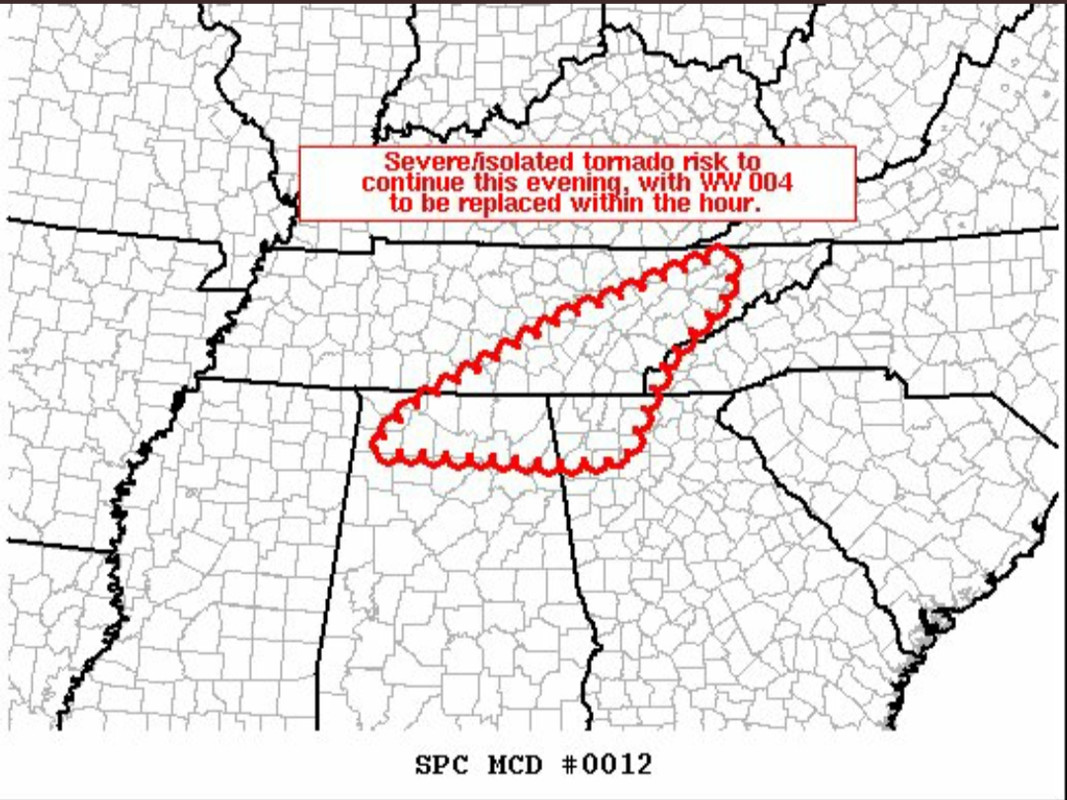
quote:
Mesoscale Discussion 0012 NWS Storm Prediction Center Norman OK 0553 PM CST Sat Jan 01 2022
Areas affected...eastern Tennessee...northern Alabama...and northwestern Georgia
Concerning...Tornado Watch 4...
Valid 012353Z - 020100Z
The severe weather threat for Tornado Watch 4 continues.
SUMMARY...Risk for locally severe storms -- including potential for a tornado or two -- continues. New WW will likely be issued within the hour, given the scheduled 02/01Z expiration of WW 004.
DISCUSSION...Latest radar loop shows a broken band comprised of several strong/severe storms, extending from northwestern Alabama to eastern portions of Middle Tennessee. While the persistently warm mid-level temperatures/weak mid-level lapse rates remain a hindrance, very strong shear -- 0-1km shear observed at 41 kt and mid-level flow west-southwesterly at 90 kt per the latest KHTX WSR-88D VWP -- will continue to support organized/rotating storms despite the thermodynamic deficiencies.
As a result, expect severe potential to continue -- and gradually expand eastward with time into areas east of WW 004. As the watch nears its scheduled expiration, a new Tornado Watch will be issued to extend from the ongoing severe convection over Middle Tennessee eastward across Tennessee and northwestern Georgia.
..Goss.. 01/01/2022
...Please see www.spc.noaa.gov for graphic product...
ATTN...WFO...GSP...MRX...FFC...OHX...BMX...HUN...
LAT...LON 36528312 36148312 35358403 34318461 34268538 34358791 34808744 35858534 36528312
Posted on 1/1/22 at 6:02 pm to LegendInMyMind
The reflectivity on the storm that’s a little south of Hamilton has that hook but doesn’t show much if any rotation from what I can tell from the Columbus radar.
Posted on 1/1/22 at 6:04 pm to NEALCD
On that one, you'd be more concerned with the notch right at Hamilton than that weird little tail. But, with the oddball rotation we've seen today, I don't know what to expect from it.
Posted on 1/1/22 at 6:07 pm to LegendInMyMind
On the storm pushing through Limestone county, the biggest area of concern for rotation will be East of Ardmore.

 Page 6 of 12

Popular
Back to top