- My Forums
- Tiger Rant
- LSU Recruiting
- SEC Rant
- Saints Talk
- Pelicans Talk
- More Sports Board
- Fantasy Sports
- Golf Board
- Soccer Board
- O-T Lounge
- Tech Board
- Home/Garden Board
- Outdoor Board
- Health/Fitness Board
- Movie/TV Board
- Book Board
- Music Board
- Political Talk
- Money Talk
- Fark Board
- Gaming Board
- Travel Board
- Food/Drink Board
- Ticket Exchange
- TD Help Board
Customize My Forums- View All Forums
- Show Left Links
- Topic Sort Options
- Trending Topics
- Recent Topics
- Active Topics
Started By
Message
 0
0

Posted on 1/1/22 at 11:37 am to LegendInMyMind
Yea no expert but I don’t think temps and dew point are enough by themselves today
Doesn’t mean the cap won’t break though
Doesn’t mean the cap won’t break though
This post was edited on 1/1/22 at 11:37 am
Posted on 1/1/22 at 11:46 am to Wishnitwas1998
Watching how quick and how many showers go up. That would be a good sign of mixing ahead of the line, and suggestive the cap gets mixed out later.
Posted on 1/1/22 at 11:49 am to Wishnitwas1998
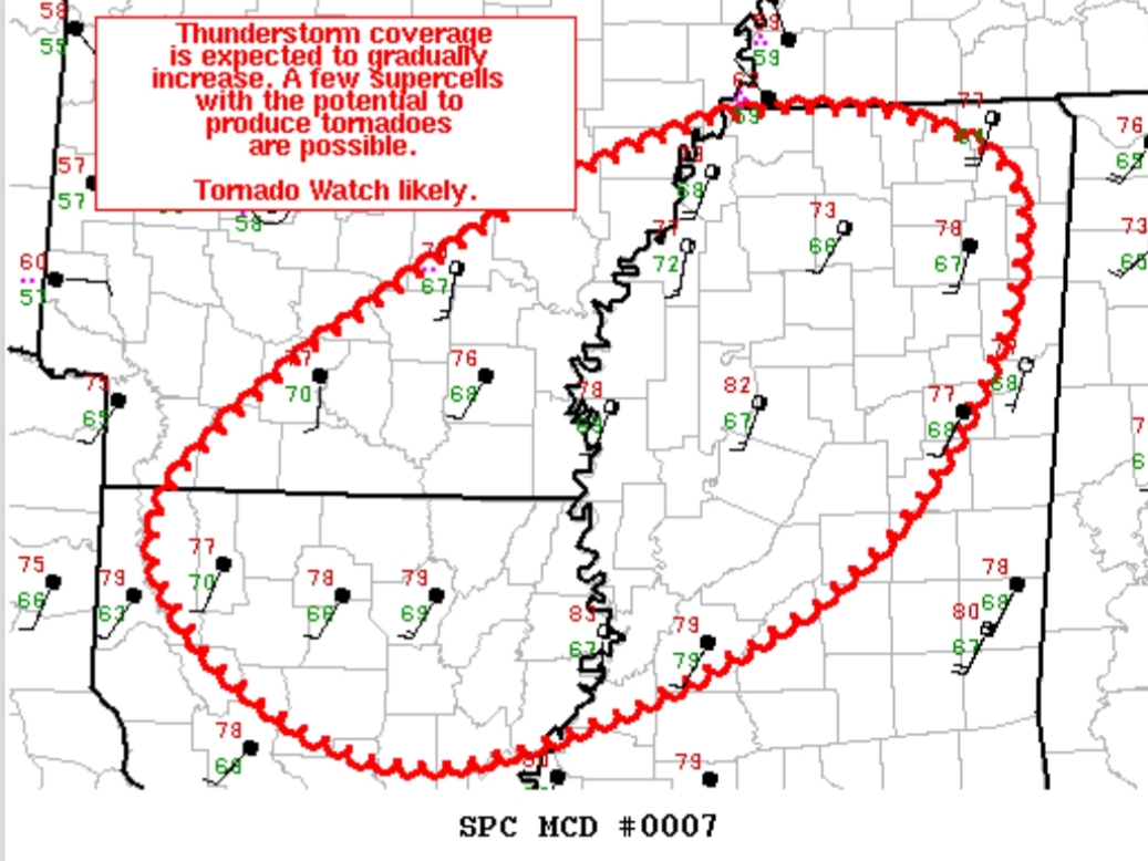
quote:
Mesoscale Discussion 0007 NWS Storm Prediction Center Norman OK 1137 AM CST Sat Jan 01 2022
Areas affected...Northern LA...Southeast AR...Central/Northern MS
Concerning...Severe potential...Tornado Watch likely
Valid 011737Z - 011930Z
Probability of Watch Issuance...95 percent
SUMMARY...A gradual increase in thunderstorm coverage is anticipated from northern LA, southeast AR, and central/northern MS this afternoon. Tornadoes are possible and a Tornado Watch will likely be issued to cover this threat.
DISCUSSION...Recent surface analysis reveals a broad warm sector in place from south-central AR/northern LA eastward into MS. Temperatures within this region are generally in the mid 70s with dewpoints in the mid to upper 60s. Objective analysis and modified RAP soundings show generally 500 to 1000 J/kg of MLCAPE, with the overall buoyancy currently limited by relatively warm mid-level temperatures. Visible satellite imagery shows numerous south-southwest to north-northeast oriented cloud bands, evidence of the increasing large scale forcing for ascent as well as persistent northward moisture return. Numerous showers have developed within these bands, and a few embedded updrafts have become strong enough to 35+ dBZ. Lightning has not been observed thus far, but the persistent moisture advection coupled with increasing large-scale forcing for ascent will likely result in at least a few more robust/organized updrafts.
Kinematic fields throughout this warm sector are quite strong, with regional VAD profiles at SHV and DGX sampling 40 to 50 kt winds in the 1 to 2 km layer. Mesoanalysis estimates effective bulk shear is over 60 kt for most of the region. Surface winds are modestly veered but the strong low to mid-level flow still results in enough low-level curvature for tornadogenesis. Expectation is for a gradual increase in updraft depth/lightning activity over the next few hours. As these storms organize, a few discrete supercells are possible, with an attendant risk for tornadoes and damaging wind gusts. A Tornado Watch will eventually be needed to cover this potential threat.
..Mosier/Grams.. 01/01/2022
...Please see www.spc.noaa.gov for graphic product...
ATTN...WFO...MEG...JAN...LZK...SHV...
LAT...LON 32789370 34289192 34988991 34468845 32698948 31679213 32789370

Posted on 1/1/22 at 11:59 am to Roll Tide Ravens
Had a little freezing rain this morning. Sucked getting bale wrap off of round bales of hay.
Posted on 1/1/22 at 12:25 pm to LegendInMyMind
Bunch of small cells popping up across ms right now
Not sure if any will be severe
Not sure if any will be severe
Posted on 1/1/22 at 12:28 pm to deltaland
quote:
Not sure if any will be severe
Watch for lightning, watch the tops.
So far the cap is holding everything in check.
Posted on 1/1/22 at 12:46 pm to LegendInMyMind
Tops now over 30k feet near Grenada. Those over the Shoals are continuing to grow, as well. Still, no lightning to speak of.
Wind is howling at 20+ steady out of the SSW here.
Wind is howling at 20+ steady out of the SSW here.
Posted on 1/1/22 at 12:50 pm to LegendInMyMind
Action Jackson sent up an 18z launch. Still a very formidable cap at 700 mb. Eyeballing about 3-4 C worth of inversion.

Posted on 1/1/22 at 12:56 pm to weadjust
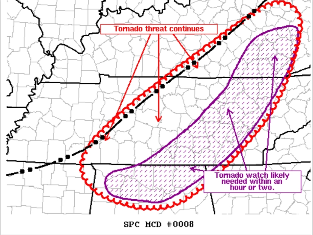
quote:
Mesoscale Discussion 0008 NWS Storm Prediction Center Norman OK 1238 PM CST Sat Jan 01 2022
Areas affected...Central KY...Middle TN...Northern AL
Concerning...Tornado Watch 3...
Valid 011838Z - 012015Z
The severe weather threat for Tornado Watch 3 continues.
SUMMARY...Threat for damaging wind gust and tornadoes continues across central KY and middle TN within Tornado Watch 3. This threat will persist downstream into more of central KY, middle TN, and northern AL, where a watch will likely be needed.
DISCUSSION...Recent observations place the outflow boundary from about 20 miles south of LEX southwestward to just southeast of BWG, continuing southeastward through western TN to about 20 miles southeast of MEM. Numerous shallow but strong/organized cells have developed along this outflow boundary and lightning has become slightly more frequent over the last hour. General trend with the stronger storms developing within the line is for an initially cell-in-line structure with a strong, more organized updraft. This more cellular structure then relatively quickly trends towards bowing line segments as the outflow boundary continues pushing southeastward. As such, a relatively brief period for tornadogenesis exists before the storms then transition to more of a damaging wind threat. Initial, more discrete development has also occurred sporadically ahead of the line, with a longer duration of more cellular structure contributing to a slightly greater tornado risk. These storms also trend towards bowing line segments as the outflow overtakes them.
This overall pattern is expected to continue for at least the next few hours as the outflow pushes quickly eastward/southeastward. Current motion places the outflow near the edge of Tornado Watch 3 by 1930Z-2000Z. Winds are currently a bit more veered downstream, but vertical shear remains very strong. As such, supercells capable of damaging wind gusts and tornadoes remain possible and a downstream watch will likely be needed.
..Mosier/Grams.. 01/01/2022
...Please see www.spc.noaa.gov for graphic product...
ATTN...WFO...MRX...JKL...FFC...LMK...OHX...HUN...MEG...
LAT...LON 35518803 37678460 37948362 37398336 35868422 34328628 34558806 35518803

Posted on 1/1/22 at 1:02 pm to LegendInMyMind
I decided not to drive home in this crap and the local news just broke into the game for the Madison county warning. These meteorologists sound very confused. Glad we have a thread to follow instead.
Posted on 1/1/22 at 1:02 pm to Duke
quote:
Action Jackson sent up an 18z launch. Still a very formidable cap at 700 mb. Eyeballing about 3-4 C worth of inversion.
I'll damn sure take it.
Posted on 1/1/22 at 1:05 pm to LegendInMyMind
Svr Warning for Tishomingo, MS.
This post was edited on 1/1/22 at 1:05 pm
Posted on 1/1/22 at 1:05 pm to LegendInMyMind
Corbin, about an hour south of Richmond in ky. The weather has been really weird all day.
Posted on 1/1/22 at 1:13 pm to LegendInMyMind
Thank God that cap is holding otherwise this would be primed for a bad day
Posted on 1/1/22 at 1:14 pm to deltaland
Tornado sirens going off here in Brentwood. I think it is west of us, not sure if anything touching down though.
Posted on 1/1/22 at 1:16 pm to calcotron
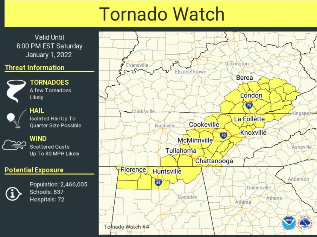
Weird. That TW was dropped/allowed to expire.

 Page 3 of 12

Popular
Back to top