- My Forums
- Tiger Rant
- LSU Recruiting
- SEC Rant
- Saints Talk
- Pelicans Talk
- More Sports Board
- Fantasy Sports
- Golf Board
- Soccer Board
- O-T Lounge
- Tech Board
- Home/Garden Board
- Outdoor Board
- Health/Fitness Board
- Movie/TV Board
- Book Board
- Music Board
- Political Talk
- Money Talk
- Fark Board
- Gaming Board
- Travel Board
- Food/Drink Board
- Ticket Exchange
- TD Help Board
Customize My Forums- View All Forums
- Show Left Links
- Topic Sort Options
- Trending Topics
- Recent Topics
- Active Topics
Started By
Message
re: New Year’s Day Severe Weather Thread - Enhanced Risk in AL, TN, MS, AR
Posted on 1/1/22 at 6:10 pm to LegendInMyMind
Posted on 1/1/22 at 6:10 pm to LegendInMyMind
Hard to tell, but we could have something on the ground near Columbus.
 2
2


Posted on 1/1/22 at 6:11 pm to LegendInMyMind

DISCUSSION...A mix of multicell clusters and transient supercell
structures should continue tracking east-northeastward from eastern
MS across parts of northern to west-central AL during the next few
hours. Here, a moist airmass (middle/upper 60s dewpoints) is
contributing to around 1000 J/kg MLCAPE where the latest VWPs show
0-6 km bulk shear of 60-70 knots. While storms have struggled across
the warm sector thus far owing to limited large-scale forcing for
ascent and weak low-level convergence, a low-level jet is expected
to overspread the area which may support a few longer-lived
multicell clusters and supercells over the next few hours. The
latest VWPs from GWX and HTX show 0-1 km SRH values of 250-300 m2/s2
ahead of the ongoing convection, which will support a risk of a few
tornadoes, damaging wind gusts, and isolated large hail with any
sustained supercells or intense multicells across the area.
This post was edited on 1/1/22 at 6:12 pm
Posted on 1/1/22 at 6:13 pm to LegendInMyMind
I imagine BMX is going to hold off on issue a tornado warning for Lamar County, AL for now.

Posted on 1/1/22 at 6:15 pm to Roll Tide Ravens
Nothing severe yet but a decent line strengthening through north Louisiana.
Posted on 1/1/22 at 6:15 pm to Roll Tide Ravens
We're about to have a tornado East of Ardmore toward Hazel Green.
Almost positive we have one. CC is shite right now, though. Bookend vortex West of Hazel Green.
Almost positive we have one. CC is shite right now, though. Bookend vortex West of Hazel Green.
This post was edited on 1/1/22 at 6:16 pm
Posted on 1/1/22 at 6:16 pm to Roll Tide Ravens
The cap is pretty much gone. Fellow North AL folks, pay attention.
Posted on 1/1/22 at 6:28 pm to LegendInMyMind
No warning on this, but I think it should be warned:
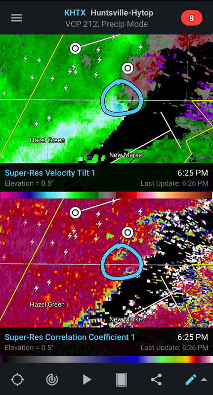
Now it is finally warned. Good grief, NWS Huntsville, get your shite together.
Now it is finally warned. Good grief, NWS Huntsville, get your shite together.
This post was edited on 1/1/22 at 6:30 pm

Posted on 1/1/22 at 6:37 pm to LegendInMyMind
It went north of me inNew Market Alabama. Watching it go through Elora and headed to the home of Johnny Majors, Huntland Tn.
Posted on 1/1/22 at 6:38 pm to footswitch
Debris pattern for Huntland. Tv report

Posted on 1/1/22 at 6:39 pm to footswitch

Posted on 1/1/22 at 6:39 pm to footswitch
Lots of chicken houses as well as population. Watch out Francisco Al
Posted on 1/1/22 at 6:39 pm to footswitch
Warning now North of Millport from the Columbus storm.
This post was edited on 1/1/22 at 6:40 pm
Posted on 1/1/22 at 6:43 pm to LegendInMyMind
Thanks again my friend.
Posted on 1/1/22 at 6:46 pm to footswitch
The very first rain is just now falling at north east Madison county Alabama state line .
Damage in Hazel Green. Tv reported
Damage in Hazel Green. Tv reported
Posted on 1/1/22 at 6:48 pm to footswitch
Now headed to Cowan and Sewanee
Posted on 1/1/22 at 6:49 pm to footswitch
Redeveloped a bit.
Posted on 1/1/22 at 6:50 pm to footswitch
Damage reports from Prospect to New Market.
Posted on 1/1/22 at 6:59 pm to LegendInMyMind
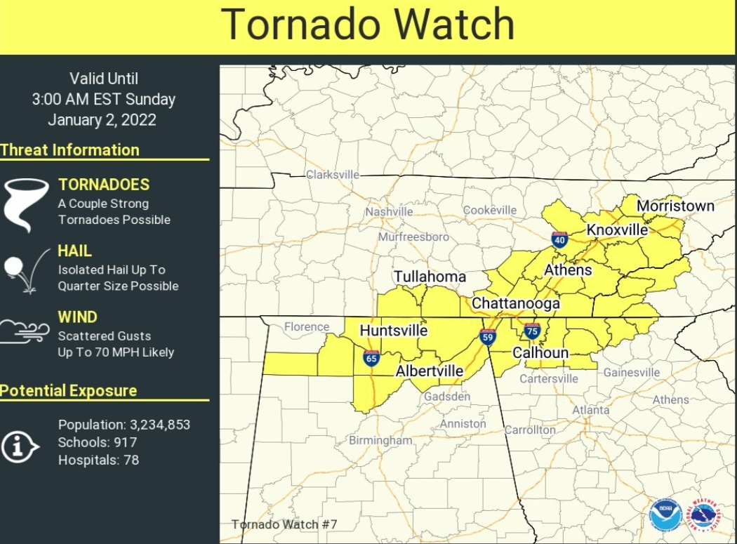
SKYWARN activated for N GA and SW NC. We’re under a watch now until 0300.

 Page 7 of 12

Popular
Back to top