- My Forums
- Tiger Rant
- LSU Recruiting
- SEC Rant
- Saints Talk
- Pelicans Talk
- More Sports Board
- Fantasy Sports
- Golf Board
- Soccer Board
- O-T Lounge
- Tech Board
- Home/Garden Board
- Outdoor Board
- Health/Fitness Board
- Movie/TV Board
- Book Board
- Music Board
- Political Talk
- Money Talk
- Fark Board
- Gaming Board
- Travel Board
- Food/Drink Board
- Ticket Exchange
- TD Help Board
Customize My Forums- View All Forums
- Show Left Links
- Topic Sort Options
- Trending Topics
- Recent Topics
- Active Topics
Started By
Message
re: New thread started for Beryl
Posted on 6/29/24 at 2:11 pm to Midtiger farm
Posted on 6/29/24 at 2:11 pm to Midtiger farm
Nice read...
U.S. Landfalling Hurricanes in June
Hurricane Audrey - 1957 (Southwest LA)
U.S. Landfalling Hurricanes in June
Hurricane Audrey - 1957 (Southwest LA)
This post was edited on 6/29/24 at 2:14 pm
 2
2

Posted on 6/29/24 at 2:16 pm to Zapps4Life
Beryl isn’t going to hit the US in June.

Posted on 6/29/24 at 2:23 pm to Zapps4Life
My grandfather talked about Hurricane Audry till the day he died...he was in insurance and said the payouts for drowned people were unreal, and they found nuns with orphans and parents with chikdren tied together with rope to try and stay together as the water came up..said nobody in the marsh areas knew it was coming
Posted on 6/29/24 at 2:36 pm to rds dc
Does the high pressure over the northern gulf keep it from making then to the north?
Posted on 6/29/24 at 2:44 pm to rds dc
Last of the major 12z guidance, the Euro EPS


Posted on 6/29/24 at 2:46 pm to rds dc
A few of those runs can suck my balls

Posted on 6/29/24 at 2:48 pm to rds dc
That one spaghetti noodle going over Baton Rouge

Posted on 6/29/24 at 3:06 pm to rds dc
That shite can just stay tfrick outta south Al.
Posted on 6/29/24 at 3:33 pm to rds dc
Keep on keepin on Heat dome. Yucatán need some action.
Posted on 6/29/24 at 3:37 pm to ArHog
BERYL IS NOW A HURRICANE AND FORECAST TO INTENSIFY QUICKLY... ...EXPECTED TO BRING LIFE-THREATENING WINDS AND STORM SURGE TO THE WINDWARD ISLANDS AS A MAJOR HURRICANE...
Posted on 6/29/24 at 3:38 pm to lsuman25
000
WTNT42 KNHC 292036
TCDAT2
Hurricane Beryl Discussion Number 5
NWS National Hurricane Center Miami FL AL022024
500 PM AST Sat Jun 29 2024
Beryl continues to rapidly strengthen, and has now become a
hurricane. Satellite images show an expanding central dense
overcast feature, and recent microwave images indicate that a
partial eyewall has formed. This intensity estimate is in agreement
with the Dvorak estimate from TAFB of T4.0/65 kt. Beryl is a
compact tropical cyclone, with its tropical-storm-force winds
estimated to extend up to 50 n mi from the center. Both the NOAA
and Air Force Reserve Hurricane Hunters are scheduled to investigate
Beryl tomorrow, and the data they collect will be very helpful in
assessing the system's structure and intensity.
Beryl continues to wobble around, but the general motion has been
westward at a quick 19 kt. A strong subtropical ridge should keep
the hurricane moving generally westward at only a slightly slower
forward speed for the next couple of days. This motion should take
Beryl across the Windward Islands late Sunday night and Monday. A
weakness in the ridge could cause Beryl to gain a little more
latitude during the early and middle portions of next week, before
turning back slightly to the left as another ridge builds to the
northwest of Beryl. The NHC track forecast is very similar to the
previous one and in fairly good agreement with the various consensus
models.
Now that Beryl has developed a compact inner core, it seems likely
that it will continue to intensify quickly since the hurricane will
remain in near ideal environmental conditions during the next day or
two. The NHC intensity forecast is again nudged upward in the short
term, and shows Beryl becoming a dangerous major hurricane prior to
it reaching the Windward Islands. Beyond a couple of days, when
Beryl is moving across the Caribbean, an increase in shear should
end the strengthening trend and induce some weakening toward the end
of the forecast period. The intensity models are coming into better
agreement on this scenario, and the NHC forecast is roughly near
the middle of the guidance envelope.
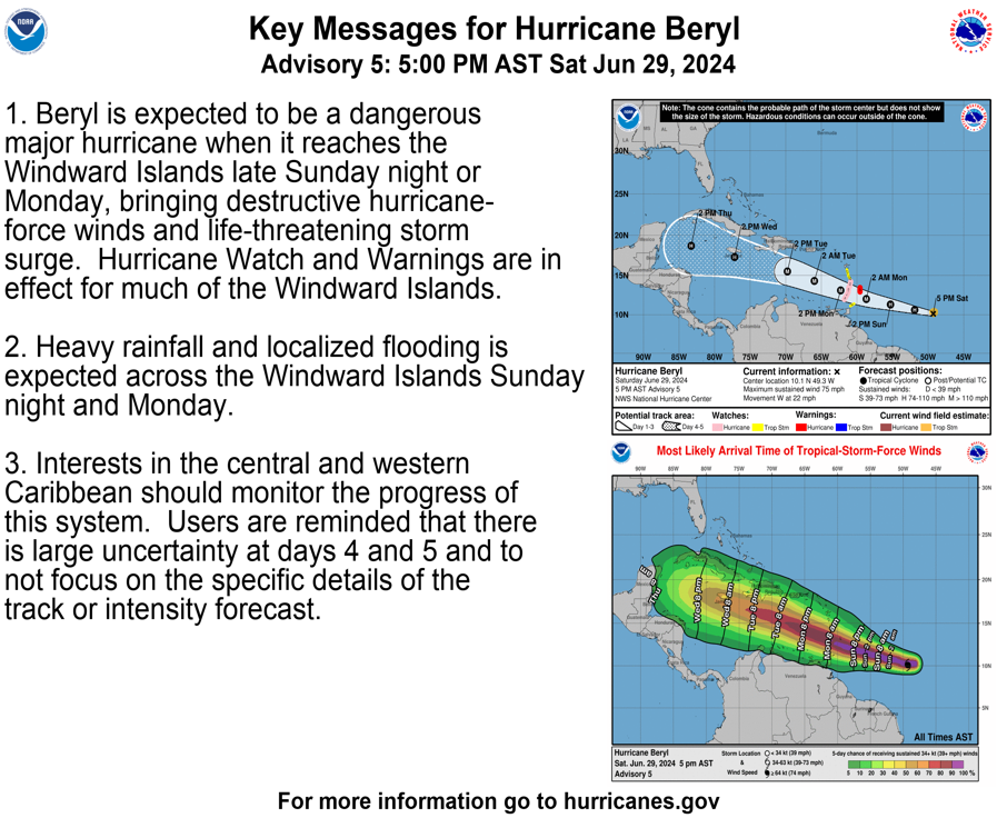
Key Messages:
1. Beryl is expected to be a dangerous major hurricane when it
reaches the Windward Islands late Sunday night or Monday,
bringing destructive hurricane-force winds and life-threatening
storm surge. Hurricane Watch and Warnings are in effect for much
of the Windward Islands.
2. Heavy rainfall and localized flooding is expected across the
Windward Islands Sunday night and Monday.
3. Interests in the central and western Caribbean should monitor the
progress of this system. Users are reminded that there is large
uncertainty at days 4 and 5 and to not focus on the specific
details of the track or intensity forecast.
FORECAST POSITIONS AND MAX WINDS
INIT 29/2100Z 10.1N 49.3W 65 KT 75 MPH
12H 30/0600Z 10.6N 51.9W 75 KT 85 MPH
24H 30/1800Z 11.3N 55.3W 90 KT 105 MPH
36H 01/0600Z 12.0N 58.7W 100 KT 115 MPH
48H 01/1800Z 13.1N 62.3W 105 KT 120 MPH
60H 02/0600Z 14.3N 66.0W 105 KT 120 MPH
72H 02/1800Z 15.5N 69.8W 100 KT 115 MPH
96H 03/1800Z 17.3N 77.2W 90 KT 105 MPH
120H 04/1800Z 18.7N 83.3W 75 KT 85 MPH
WTNT42 KNHC 292036
TCDAT2
Hurricane Beryl Discussion Number 5
NWS National Hurricane Center Miami FL AL022024
500 PM AST Sat Jun 29 2024
Beryl continues to rapidly strengthen, and has now become a
hurricane. Satellite images show an expanding central dense
overcast feature, and recent microwave images indicate that a
partial eyewall has formed. This intensity estimate is in agreement
with the Dvorak estimate from TAFB of T4.0/65 kt. Beryl is a
compact tropical cyclone, with its tropical-storm-force winds
estimated to extend up to 50 n mi from the center. Both the NOAA
and Air Force Reserve Hurricane Hunters are scheduled to investigate
Beryl tomorrow, and the data they collect will be very helpful in
assessing the system's structure and intensity.
Beryl continues to wobble around, but the general motion has been
westward at a quick 19 kt. A strong subtropical ridge should keep
the hurricane moving generally westward at only a slightly slower
forward speed for the next couple of days. This motion should take
Beryl across the Windward Islands late Sunday night and Monday. A
weakness in the ridge could cause Beryl to gain a little more
latitude during the early and middle portions of next week, before
turning back slightly to the left as another ridge builds to the
northwest of Beryl. The NHC track forecast is very similar to the
previous one and in fairly good agreement with the various consensus
models.
Now that Beryl has developed a compact inner core, it seems likely
that it will continue to intensify quickly since the hurricane will
remain in near ideal environmental conditions during the next day or
two. The NHC intensity forecast is again nudged upward in the short
term, and shows Beryl becoming a dangerous major hurricane prior to
it reaching the Windward Islands. Beyond a couple of days, when
Beryl is moving across the Caribbean, an increase in shear should
end the strengthening trend and induce some weakening toward the end
of the forecast period. The intensity models are coming into better
agreement on this scenario, and the NHC forecast is roughly near
the middle of the guidance envelope.
Key Messages:
1. Beryl is expected to be a dangerous major hurricane when it
reaches the Windward Islands late Sunday night or Monday,
bringing destructive hurricane-force winds and life-threatening
storm surge. Hurricane Watch and Warnings are in effect for much
of the Windward Islands.
2. Heavy rainfall and localized flooding is expected across the
Windward Islands Sunday night and Monday.
3. Interests in the central and western Caribbean should monitor the
progress of this system. Users are reminded that there is large
uncertainty at days 4 and 5 and to not focus on the specific
details of the track or intensity forecast.
FORECAST POSITIONS AND MAX WINDS
INIT 29/2100Z 10.1N 49.3W 65 KT 75 MPH
12H 30/0600Z 10.6N 51.9W 75 KT 85 MPH
24H 30/1800Z 11.3N 55.3W 90 KT 105 MPH
36H 01/0600Z 12.0N 58.7W 100 KT 115 MPH
48H 01/1800Z 13.1N 62.3W 105 KT 120 MPH
60H 02/0600Z 14.3N 66.0W 105 KT 120 MPH
72H 02/1800Z 15.5N 69.8W 100 KT 115 MPH
96H 03/1800Z 17.3N 77.2W 90 KT 105 MPH
120H 04/1800Z 18.7N 83.3W 75 KT 85 MPH

Posted on 6/29/24 at 3:48 pm to lsuman25
quote:
BERYL IS NOW A HURRICANE

Posted on 6/29/24 at 3:49 pm to Bobby OG Johnson
Least the Hurricane Hunters will be flying into Beryl tomorrow
Posted on 6/29/24 at 3:50 pm to lsuman25

Posted on 6/29/24 at 3:51 pm to LegendInMyMind
quote:
This just fricked my mind for a minute until I realized that there is a very distinct possibility that you haven't always lived in Wichita.
This post was edited on 6/29/24 at 3:52 pm
Posted on 6/29/24 at 3:54 pm to Bobby OG Johnson
On Levi's site still has it as a TS, he's slacking. 
Posted on 6/29/24 at 4:07 pm to lsuman25
I need to know if I am right in calling this Hurricane Barrel, or are they going with some weird pronunciation?

Posted on 6/29/24 at 4:08 pm to LegendInMyMind
Ber-rill is how it's pronounced
Posted on 6/29/24 at 4:09 pm to choppadocta
quote:
Ber-rill is how it's pronounced
I'm sticking with Hurricane Barrel.

Posted on 6/29/24 at 4:09 pm to choppadocta
Cone half H shift south at Jamaica

 Page 34 of 39

Popular
Back to top