- My Forums
- Tiger Rant
- LSU Recruiting
- SEC Rant
- Saints Talk
- Pelicans Talk
- More Sports Board
- Coaching Changes
- Fantasy Sports
- Golf Board
- Soccer Board
- O-T Lounge
- Tech Board
- Home/Garden Board
- Outdoor Board
- Health/Fitness Board
- Movie/TV Board
- Book Board
- Music Board
- Political Talk
- Money Talk
- Fark Board
- Gaming Board
- Travel Board
- Food/Drink Board
- Ticket Exchange
- TD Help Board
Customize My Forums- View All Forums
- Show Left Links
- Topic Sort Options
- Trending Topics
- Recent Topics
- Active Topics
Started By
Message
re: Multi-day Severe Weather Threat: 3/23-3/24
Posted on 3/24/23 at 9:37 pm to LegendInMyMind
Posted on 3/24/23 at 9:37 pm to LegendInMyMind
tornado is heading into Winona right now
 1
1

Posted on 3/24/23 at 9:37 pm to rt3
quote:
storm chaser Brandon Copic apparently almost slammed into a tree that was on the road
I honestly don't know how this doesn't happen more often. With power outages, debris everywhere, and tensions high....
Posted on 3/24/23 at 9:38 pm to deltaland
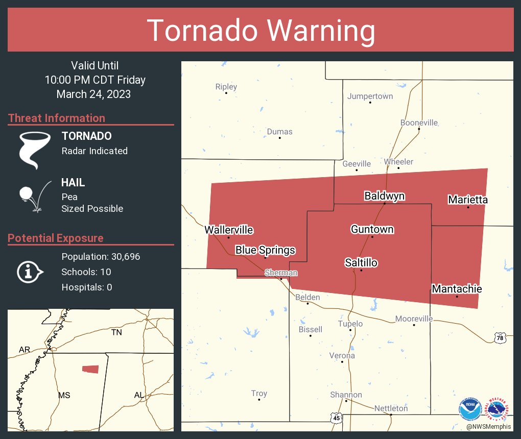
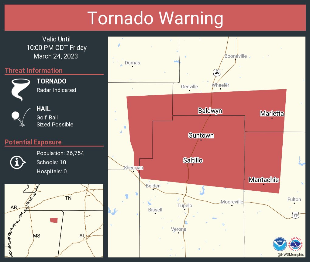
Winona in path
Severe Weather Statement
National Weather Service Jackson MS
932 PM CDT Fri Mar 24 2023
MSC015-097-155-250315-
/O.CON.KJAN.TO.W.0030.000000T0000Z-230325T0315Z/
Carroll MS-Webster MS-Montgomery MS-
932 PM CDT Fri Mar 24 2023
...TORNADO EMERGENCY FOR WINONA...
...A TORNADO WARNING REMAINS IN EFFECT UNTIL 1015 PM CDT FOR EASTERN
CARROLL...WEBSTER AND MONTGOMERY COUNTIES...
At 932 PM CDT, a confirmed large and destructive tornado was located
over Winona, moving northeast at 60 mph.
TORNADO EMERGENCY for WINONA! This is a PARTICULARLY DANGEROUS
SITUATION. TAKE COVER NOW!
HAZARD...Deadly tornado.
SOURCE...Radar confirmed tornado.
IMPACT...You are in a life-threatening situation. Flying debris may
be deadly to those caught without shelter. Mobile homes
will be destroyed. Considerable damage to homes,
businesses, and vehicles is likely and complete destruction
is possible.
The tornado will be near...
Kilmichael around 940 PM CDT.
Lodi and Sweatman around 945 PM CDT.
Eupora, Bellefontaine and Embry around 1000 PM CDT.
Other locations impacted by this tornadic thunderstorm include
Walthall.
Posted on 3/24/23 at 9:38 pm to Pisco
Lady that cuts my hair is headed to rolling fork with some people to rescue one of her clients pinned down in their house
Posted on 3/24/23 at 9:39 pm to deltaland
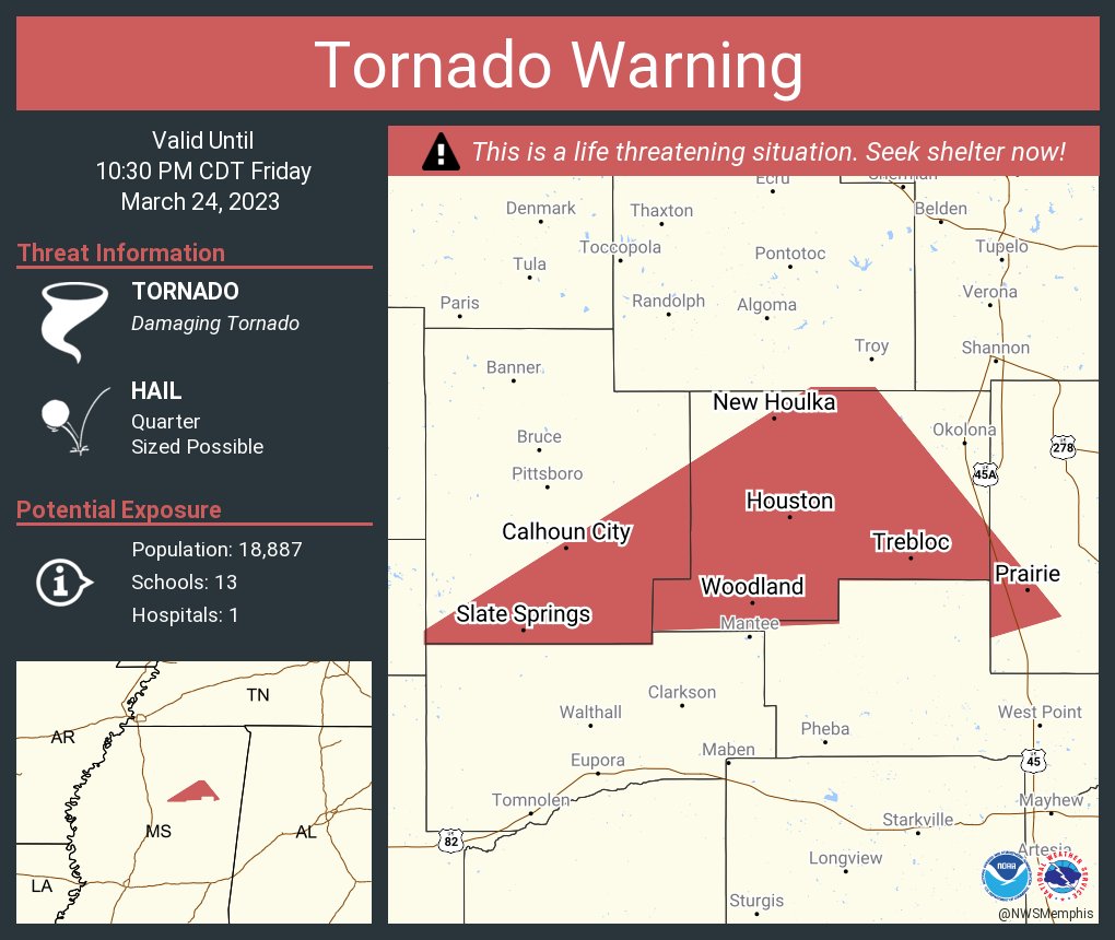
Ans that Northern storm is warned now.

Posted on 3/24/23 at 9:39 pm to NorthEndZone
May post the Radar Indicated just for good measure
Posted on 3/24/23 at 9:41 pm to deltaland
It passed between our camp and hwy 14 east of Anguilla. Heading up tomorrow morning to assess damage. Praying for the folks in the Delta who have been affected by this

Posted on 3/24/23 at 9:41 pm to deltaland
The ex has some family in Winona. Hope they make it out alright.
Posted on 3/24/23 at 9:42 pm to deltaland
It just hit Winona. WLBT had it at 135 mph. This is going to be bad very bad.
Posted on 3/24/23 at 9:43 pm to deathinthedelta
Did it miss Anguilla?
Posted on 3/24/23 at 9:44 pm to Bobby OG Johnson
Rolling Fork Tornado

Posted on 3/24/23 at 9:45 pm to Bobby OG Johnson
PDS
Posted on 3/24/23 at 9:46 pm to deltaland
Delta I guess I should know this. Ur what city are you in??? Stay safe.

Posted on 3/24/23 at 9:47 pm to Bobby OG Johnson
Damn this place is the best for quick news updates.

Posted on 3/24/23 at 9:48 pm to deltaland
Hopefully north MS will be fine. I have family south of Corinth and I can be there in
less than 3 hours.
less than 3 hours.
Posted on 3/24/23 at 9:48 pm to Bobby OG Johnson

Posted on 3/24/23 at 9:49 pm to Rebel
here and youtube
ryan hall youtube
also radar omega app which has killer radar and has storm chasers live feeds
ryan hall youtube
also radar omega app which has killer radar and has storm chasers live feeds
Posted on 3/24/23 at 9:49 pm to tiger91
I’m in Inverness we are ok here so far

Posted on 3/24/23 at 9:49 pm to Bobby OG Johnson
I haven’t stayed plugged in like this evening I usually do. Looks like this one storm has been a monster. Hopefully it’ll settle down some as things move into Alabama.
Posted on 3/24/23 at 9:49 pm to tes fou
Looks like the tor lifted after passing through Winona. Let's see if it is winding down a bit or cycling.

 Page 13 of 32

Popular
Back to top