- My Forums
- Tiger Rant
- LSU Recruiting
- SEC Rant
- Saints Talk
- Pelicans Talk
- More Sports Board
- Fantasy Sports
- Golf Board
- Soccer Board
- O-T Lounge
- Tech Board
- Home/Garden Board
- Outdoor Board
- Health/Fitness Board
- Movie/TV Board
- Book Board
- Music Board
- Political Talk
- Money Talk
- Fark Board
- Gaming Board
- Travel Board
- Food/Drink Board
- Ticket Exchange
- TD Help Board
Customize My Forums- View All Forums
- Show Left Links
- Topic Sort Options
- Trending Topics
- Recent Topics
- Active Topics
Started By
Message

Multi-day Severe Weather Threat: 3/23-3/24
Posted on 3/22/23 at 2:17 pm
Posted on 3/22/23 at 2:17 pm
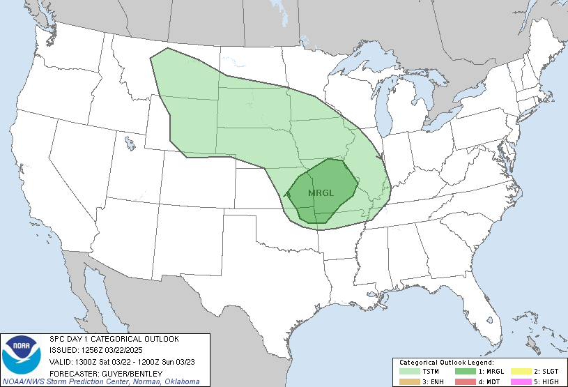
SPC DAY 1 outlook


quote:
...SUMMARY... A severe weather outbreak remains possible across the Lower Mississippi Valley and Mid-South. The most likely time period for strong tornadoes is between 5 pm to Midnight CDT. ...Lower MS Valley, Mid-South, and the TN Valley... Thunderstorms are ongoing along a baroclinic zone from KY southwest to the Edwards Plateau in central TX. Composite outflow has effectively shunted the surface front southeastward this morning. Most CAMs that reasonably handled this convection suggest the recent weakening trend will continue through late morning before renewed storm development occurs towards early afternoon in the OK/TX/AR border vicinity near the primary surface cyclone. This latter activity should drive the broader coverage portion of the severe threat as the surface cyclone deepens and tracks northeast along the baroclinic zone through tonight. Reliable CAM guidance is largely in agreement that an intensifying QLCS will evolve across AR and spread towards the TN Valley through the evening. Here, strengthening low-level winds and enlarging hodographs should compensate for the northern gradient of the surface-based instability plume. This QLCS will likely contain embedded supercell and mesovortex structures supportive of tornadoes (including potential for a few EF2s) and significant damaging wind swaths (up to around 90 mph). Farther south, GOES PW imagery and the 12Z LCH/LIX soundings indicate values have fallen to near an 1 inch along the central Gulf Coast. This dryness pocket above 850 mb will limit buoyancy across the Lower MS Valley until late today. Increasing low-level moisture across the Sabine Valley towards the Ark-La-Miss should eventually yield a plume of moderate MLCAPE around 1500 J/kg by evening. This warm theta-e advection regime should also foster some discrete convection ahead/southeast of the QLCS towards late afternoon into early evening within the resultant MLCAPE gradient. Deep-layer shear profiles will support supercells, a few of which could become long-tracked. Low-level hodographs, while not quite as enlarged as compared to farther north, will favor a threat for strong tornadoes (EF2-3), until warm sector winds becomes increasingly veered from southwest to northeast overnight.
This post was edited on 3/24/23 at 8:08 am
Posted on 3/22/23 at 2:19 pm to Lsuhoohoo
The memes will just write themselves with this one.
Posted on 3/22/23 at 2:21 pm to Lsuhoohoo
This looks like a real deal Springtime severe weather outbreak
School administrators finna eat and call a 3 day weekend


School administrators finna eat and call a 3 day weekend


Posted on 3/22/23 at 2:21 pm to Lsuhoohoo
This isnt going to stop me from boiling crawfish saturday.
Posted on 3/22/23 at 2:23 pm to zadams_318
Inb4 "that's a penis" gif
Posted on 3/22/23 at 2:24 pm to Lsuhoohoo
OMG!!! Cancel……..Everything!
Posted on 3/22/23 at 2:25 pm to Lsuhoohoo
well NY is about to get effed in the B
Posted on 3/22/23 at 2:26 pm to The Boat
BMX AFD had some pretty strong wording about a classic look suggestive or a tornado outbreak but I decided not to include that in the OP at this point. Still some uncertainties to clear up
Posted on 3/22/23 at 2:26 pm to Lsuhoohoo
Everybody just got their power back on from the last one. 

They're saying we may have 4"+ rain on Friday. Thankfully we're at a higher point of the county but the Ohio River is almost certainly going to flood after this one.
They're saying we may have 4"+ rain on Friday. Thankfully we're at a higher point of the county but the Ohio River is almost certainly going to flood after this one.
Posted on 3/22/23 at 2:30 pm to Lsuhoohoo
Don't ignore the profile of a dog's head in Utah and Nevada
Posted on 3/22/23 at 2:32 pm to The Boat
Dammit Boat! I see the edited thread. I scrolled through the pages to make sure the thread hadn't been started, I gave it time to see if one of our credible weather nerds would start it and then you started yours 3 minutes after mine. I'm out of my element starting weather threads. 
Posted on 3/22/23 at 2:35 pm to tigerbutt
quote:
OMG!!! Cancel……..Everything!
Mask up!
Posted on 3/22/23 at 2:36 pm to Lsuhoohoo
Yeah I saw one hadn't been started yet so I made one since it's going to be a pretty high end event to give people a heads up. I'll be busy working it Friday so I won't be here to update it anyways so it's for the best.
Posted on 3/22/23 at 2:48 pm to kengel2
quote:
This isnt going to stop me from boiling crawfish saturday.
Even if this makes the price go up?
Posted on 3/22/23 at 2:50 pm to Bestbank Tiger
quote:
Even if this makes the price go up?
Lol. Nope, this is my weekend. Got stuff planned like every weekend, so I'm in no matter what.
Posted on 3/22/23 at 2:59 pm to The Boat
The trend continues for the same general area. Higher threat on the western extent again. Tomorrow could see more big hail for our Texas baws.
Posted on 3/22/23 at 3:07 pm to LegendInMyMind
those Hailers in TX is crushing my wife's work (insurance adjuster). those plus all the shite in California, and they are getting just inundated with claims
Posted on 3/22/23 at 3:25 pm to Thracken13
quote:
those plus all the shite in California, and they are getting just inundated with claims
Small twister just touched down near Los Angeles about an hour ago
Popular
Back to top

 20
20


