- My Forums
- Tiger Rant
- LSU Recruiting
- SEC Rant
- Saints Talk
- Pelicans Talk
- More Sports Board
- Fantasy Sports
- Golf Board
- Soccer Board
- O-T Lounge
- Tech Board
- Home/Garden Board
- Outdoor Board
- Health/Fitness Board
- Movie/TV Board
- Book Board
- Music Board
- Political Talk
- Money Talk
- Fark Board
- Gaming Board
- Travel Board
- Food/Drink Board
- Ticket Exchange
- TD Help Board
Customize My Forums- View All Forums
- Show Left Links
- Topic Sort Options
- Trending Topics
- Recent Topics
- Active Topics
Started By
Message

 0
0

Posted on 3/10/16 at 3:49 pm to Large Farva
quote:shite I'm not to far from there and my back yard backs up to the subdivision fishing pond...
My parents house in Shenandoah has close to 4 inches of water on their patio.

Posted on 3/10/16 at 3:49 pm to rds dc
23.5 inches of rain at my house...just east of Swartz

Posted on 3/10/16 at 3:51 pm to East Coast Band
.
Looks like the same guy colored both of these:

Except this one sold for $120 million.

Looks like the same guy colored both of these:
Except this one sold for $120 million.
Posted on 3/10/16 at 3:52 pm to jeffsdad
Posted on 3/10/16 at 3:55 pm to jeffsdad
18z 4k NAM is still showing a lot of for the New Orleans area

Posted on 3/10/16 at 3:56 pm to CuseTiger
Sun is out in BR.
Posted on 3/10/16 at 3:58 pm to zacata88
What? It's almost dark where I am.
Posted on 3/10/16 at 4:00 pm to MrSmith
Where I am near downtown the sun is shining through the clouds and birds are out chirping 
Posted on 3/10/16 at 4:02 pm to rds dc
That forecast is from now until Sunday and the highest point is 9.2 near the lake. That's still way better than the previous forecasts that showed 10-12 inches all over New Orleans.
Posted on 3/10/16 at 4:03 pm to Large Farva
My thoughts are with the folks whose homes were damaged by the tornadoes two weeks ago. Hard rain is not what those damaged homes need right now.
Posted on 3/10/16 at 4:03 pm to zacata88
That's pretty strange I'm near Siegen
Posted on 3/10/16 at 4:07 pm to Champagne
Amen. My home isn't even fixed (insurance took forever) and we need a new roof.. Guess it's just more work for the people redoing my sheet rock!
Posted on 3/10/16 at 4:07 pm to rds dc
Rain just started here in Elmwood.
Posted on 3/10/16 at 4:07 pm to TigerstuckinMS
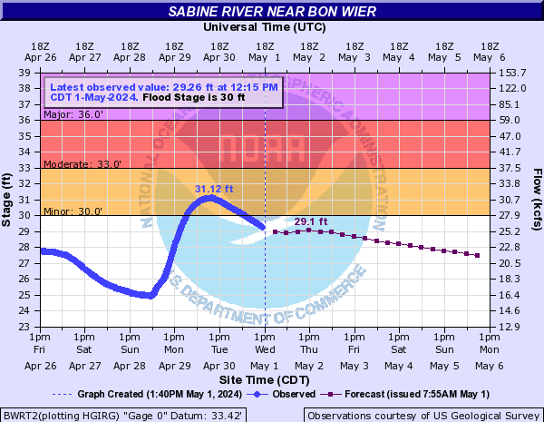
The towns along the Sabine River south of Toledo Bend are going to be in a world of hurt in the next few days.
This is from Bon Wier, TX during the flood of February 1999 when the Sabine was at 37ft at the Bon Wier gauge. This house is on stilts but many aren't and were flooded severely at 37 feet.

It is currently projected to get to 39.6 feet there:
This is Deweyville, TX in 1953 when the river crested at 29.98 ft.

Projections for Deweyville are to obliterate their previous record and continue rising past the forecast period. They show it getting to 33.6 feet and higher:

This is from Bon Wier, TX during the flood of February 1999 when the Sabine was at 37ft at the Bon Wier gauge. This house is on stilts but many aren't and were flooded severely at 37 feet.
It is currently projected to get to 39.6 feet there:
quote:
43.5 The river is at its unofficial highest gage reading set in April 1913. Widespread catastrophic flooding will occur.
38.97 The river is at its flood of record. Widespread major to catastrophic flooding will occur.
36 Major lowland flooding will occur. Sabine Sands Road has about one to three feet of water covering the road.
35 Expect several secondary roads in the Merryville area near the river to be closed.
33 Moderate lowland flooding will occur. Low-lying roads and a few homes have some flooding between Bon Wier and Merryville. Camp houses along the river in Southwest Vernon Parish begin to flood.
This is Deweyville, TX in 1953 when the river crested at 29.98 ft.
Projections for Deweyville are to obliterate their previous record and continue rising past the forecast period. They show it getting to 33.6 feet and higher:
quote:
32.7 The river has reached its unofficial highest gage reading previously set in May 1884. Widespread catastrophic flooding will occur.
29.98 The river is at its flood of record. Widespread major to catastrophic flooding will occur.
29 Major flooing occurring leaving the town of Deweyville isolated. Numerous homes are flooded.
27.9 This flooding will be similar to the flooding expierenced in the flood of March 2001. Homes in Deweyville have water in them.
27 Widespread moderate lowland flooding will occur. Homes in Deweyville closest to the river are flooded. Flooding of homes in the Indian Lakes and River Oaks sections will also occur. Low-lying roads and a few homes in Southwest Beauregard Parish have some flooding.
26.8 Deweyville schools may be closed due to school bus routes being flooded.
26 Moderate lowland flooding will occur. The lowest homes between Deweyville and the river begin to flood, especially in the Indian Lakes and River Oaks sections. Low-lying roads and a few homes in Southwestern Beauregard Parish have some flooding.

Posted on 3/10/16 at 4:11 pm to slackster
Slackster, thanks for your help and advice earlier today.
I left Ruston around 1:45 for BR and would have been smooth sailing and even arrived in BR during the "break" in the rain but I had to turn around abt 40 miles north of Alexandria because 167 south was flooded.
I left Ruston around 1:45 for BR and would have been smooth sailing and even arrived in BR during the "break" in the rain but I had to turn around abt 40 miles north of Alexandria because 167 south was flooded.
Posted on 3/10/16 at 4:12 pm to slackster
Now I'm probably stuck here in Ruston till Saturday
Posted on 3/10/16 at 4:21 pm to 225bred
quote:
Now I'm probably stuck here in Ruston till Saturday
Yeesh. No problem man, hopefully it recedes soon and people can get back on the road. I suppose you could try to head through Mississippi at some point but that doesn't really keep you out of the rain.
Posted on 3/10/16 at 4:23 pm to slackster
My fear of taking I20 east to Vicksburg and I55 south to BR is that if I encounter flooding or closures in Mississippi I'm stuck there.
Posted on 3/10/16 at 4:28 pm to 225bred
I think you'd make it ok, just a rainy drive. This band should die out before another one moves in overnight. The good people at the NWS in Slidell think that one will carry more rain. So the flood threat is only going to increase going into tomorrow.

 Page 45 of 102

Popular
Back to top