




- My Forums
- Tiger Rant
- LSU Recruiting
- SEC Rant
- Saints Talk
- Pelicans Talk
- More Sports Board
- Fantasy Sports
- Golf Board
- Soccer Board
- O-T Lounge
- Tech Board
- Home/Garden Board
- Outdoor Board
- Health/Fitness Board
- Movie/TV Board
- Book Board
- Music Board
- Political Talk
- Money Talk
- Fark Board
- Gaming Board
- Travel Board
- Food/Drink Board
- Ticket Exchange
- TD Help Board
Customize My Forums- View All Forums
- Show Left Links
- Topic Sort Options
- Trending Topics
- Recent Topics
- Active Topics
Started By
Message
 0
0


Posted on 8/26/20 at 12:49 pm to GeauxEdits
When is the last time y’all have seen a storm upgrade from a TS to a Cat 4 in less than 36 hours? I mean hell, wasn’t it a TS yesterday?


Posted on 8/26/20 at 12:49 pm to Roll Tide Ravens
Well, she only needs 17mph more in her sustained winds to be a Cat. 5.


Posted on 8/26/20 at 12:49 pm to TigersLSU
Live cam at I10 and bridge 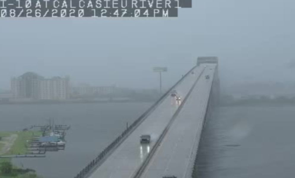
Posted on 8/26/20 at 12:49 pm to The Boat
quote:
Gustav maxed out right before it went over the Isle of Youth and Cuba which really disrupted its core then the Gulf wasn't primed for it. The wind shear and dry air were tough. It was hard to follow the 08 season as close without power for much of it but it just wasn't a good year for conditions in the Gulf.
Laura actually benefited from only being a disorganized TS during its time passing over/near Cuba. Crazy to think that had it been a hurricane there, it would have weakened, and would be trying to reorganize now.

Posted on 8/26/20 at 12:49 pm to CaptainJ47
quote:
Slack- since you are in MC would be happy to buy you breakfast at The Galley or wherever once this shite passes.
Dinner at Cafe Jo Jo’s?

Posted on 8/26/20 at 12:49 pm to DomincDecoco
Cat 4. Could grow to a Cat 5. God Bless those folks
Posted on 8/26/20 at 12:50 pm to bayoubengals88
quote:
Surely tech has improved tremendously in nearly 20 years.
You would think.


Posted on 8/26/20 at 12:50 pm to DomincDecoco
Dumb question here...
I know people make fun of the I-10 bridge in LC, but are we concerned about this surviving the NE Q of Laura?
I know people make fun of the I-10 bridge in LC, but are we concerned about this surviving the NE Q of Laura?
Posted on 8/26/20 at 12:50 pm to Roll Tide Ravens
Approx. 122 knot SFMR and 128 knots flight level
Wow

Wow


Posted on 8/26/20 at 12:50 pm to tigahfan747

quote:
DISCUSSION...Convective band associated with Hurricane Laura is
currently moving northward into far southern LA. Storms within the
band are generally moving northwestward, with shallow,
short-duration/pulse-like updrafts thus far. Additionally, northward
motion of the entire band suggests predominantly outflow-dominant
storm structures. Given the strength of the low-level wind fields,
some of these outflows could produce 40-50 kt gusts.
Low-level kinematic environment will continue to improve across the
region as Laura approaches. Current LIX VAD profiles and recent
mesoanalysis suggest around 20-25 kt of 0-1 km bulk shear and
100-150 m2/s2 of 0-1 km storm-relative helicity are already in place
across the region. Gradual strengthening is anticipated over the
next few hours, particularly as the stronger low to mid-level flow
moves over the region, lengthening the hodographs.
Modest thermodynamics are in place, suggesting storms will continue
to develop on the outflow, but the overall kinematic environment
does not appear overly supportive of tornadogenesis on a large
scale. Even so, given the strengthening of the low-level wind fields
that is anticipated, trends will be monitored closely and a watch
will be needed later this afternoon.
This post was edited on 8/26/20 at 12:51 pm
Posted on 8/26/20 at 12:51 pm to berrycajun
quote:
The red and white oaks in oak hills are always falling. It seems like they are worse than the water oaks
Hope not. Got a big red oak in our yard.
Posted on 8/26/20 at 12:51 pm to 50_Tiger
quote:
I wonder if 5 is now on the table?
Hell, it appears to have no ceiling right now. As Duke said, hoping for the start of an EWRC just as it starts its final approach is the best bet for weakening or at least leveling off. That, and the shallower water, but it is plenty warm and Laura is moving fast.


Posted on 8/26/20 at 12:51 pm to 50_Tiger
I dont think thats a dumb question at all. I imagine its going to make it through fine but i imagine that has to be a valid concern


Posted on 8/26/20 at 12:51 pm to DomincDecoco
quote:
Live cam at I10 and bridge
frick driving over that POS right now
Posted on 8/26/20 at 12:52 pm to NorthEndZone
So, is it about to get bad in Baton Rouge?
Posted on 8/26/20 at 12:52 pm to 50_Tiger
quote:
I wonder if 5 is now on the table?
I won’t say that it is super likely, but I don’t think anything can be taken off the table at this point.
Maybe Laura will do what Michael did and strengthen up to landfall.
This post was edited on 8/26/20 at 12:53 pm

Posted on 8/26/20 at 12:52 pm to Pedro
Never seen the TWC with this storm surge map showing individual streets, buildings hotels.
They showed L'auberge, Golden Nugget, City Hall downtown buildings and neighborhoods
wow
They showed L'auberge, Golden Nugget, City Hall downtown buildings and neighborhoods
wow
This post was edited on 8/26/20 at 12:57 pm
Posted on 8/26/20 at 12:53 pm to DomincDecoco
quote:
DomincDecoco
Link to the live cam


Posted on 8/26/20 at 12:53 pm to 50_Tiger
quote:
Dumb question here... I know people make fun of the I-10 bridge in LC, but are we concerned about this surviving the NE Q of Laura?
As long as no one’s on it and it doesn’t fall on anyone that wouldn’t be the worst thing in the world. Then they’d be forced to replace it instead of farting in the wind and telling us they’ll replace it 20 years from now when it needed to be replaced 60 years ago.

 Page 482 of 815

Popular
Back to top
 Follow TigerDroppings for LSU Football News