- My Forums
- Tiger Rant
- LSU Recruiting
- SEC Rant
- Saints Talk
- Pelicans Talk
- More Sports Board
- Coaching Changes
- Fantasy Sports
- Golf Board
- Soccer Board
- O-T Lounge
- Tech Board
- Home/Garden Board
- Outdoor Board
- Health/Fitness Board
- Movie/TV Board
- Book Board
- Music Board
- Political Talk
- Money Talk
- Fark Board
- Gaming Board
- Travel Board
- Food/Drink Board
- Ticket Exchange
- TD Help Board
Customize My Forums- View All Forums
- Show Left Links
- Topic Sort Options
- Trending Topics
- Recent Topics
- Active Topics
Started By
Message
re: Ian Observation Thread (Storm Track and Radar inside)
Posted on 9/29/22 at 9:20 am to FLBooGoTigs1
Posted on 9/29/22 at 9:20 am to FLBooGoTigs1
Yeah. 25 miles is well within the margin of track forecast error 24 hours from landfall, but makes a huge difference in impact for a specific area - especially for surge.
 1
1


Posted on 9/29/22 at 9:24 am to NorthEndZone
Help is on the way
40k+ linemen are waiting by in Florida right now ready to go to work when they can.
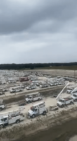
40k+ linemen are waiting by in Florida right now ready to go to work when they can.
Posted on 9/29/22 at 9:24 am to MorbidTheClown
quote:
Help is on the way
40k+ linemen are waiting by in Florida right now ready to go to work when they can.
That's a ton of overnight truck fapping.

Posted on 9/29/22 at 9:25 am to Zapps4Life
From those pics Ian may have time to build back up to CAT 1 but it is speeding up so hopefully if it hits Charleston it will be with tropical storm winds and finally fizzles out in the mountains of Tennessee.
This post was edited on 9/29/22 at 9:36 am
Posted on 9/29/22 at 9:30 am to FLBooGoTigs1
quote:
hopefully it hits Charleston
I wouldn’t root for that. That could be devastating to Charleston. Why not just hope it heads out to see or lands in a much less populated area of the coast?

Posted on 9/29/22 at 9:32 am to Seen
quote:
That's insane current. I was a little over a year in my ems career, started in New Orleans, when Katrina hit. I don't even remember seeing current like that but maybe I've simply forgotten. Lots of standing water for sure.
Yeah, there are some videos where you can honestly see white caps as the water moved through Bonita Springs. And in that video, that's surge coming in, not going out yet, which would have likely been worse.
Posted on 9/29/22 at 9:34 am to Chucktown_Badger
Definitely the wrong choice of words I was just looking at the last track and where it was heading. My main intention was to hope it doesn't increase significantly in intensity wherever Ian goes.
Eta: I edited last post
Eta: I edited last post
This post was edited on 9/29/22 at 9:36 am
Posted on 9/29/22 at 9:35 am to Oates Mustache
I just found out the surge did not come up our street. Sadly for most of our friends that is not true. Massive damage to total destruction for their homes but they are all safe.
I may try to get to our house this weekend as we left with small suitcases and could use some more clothing.
I may try to get to our house this weekend as we left with small suitcases and could use some more clothing.

Posted on 9/29/22 at 9:35 am to FLBooGoTigs1
I understood what you were saying, just hoping it doesn’t strengthen.
Posted on 9/29/22 at 9:36 am to PsychTiger
Charleston doesn’t need a 1 right now.
No one does really though.
No one does really though.

Posted on 9/29/22 at 9:36 am to Chucktown_Badger
quote:
I wouldn’t root for that. That could be devastating to Charleston. Why not just hope it heads out to see or lands in a much less populated area of the coast?
A cat 1 storm would not be "devastating" to Charleston. It would certainly be a bit messy, sure, but come on!

Posted on 9/29/22 at 9:37 am to VABuckeye
Glad to hear your house made it through safely. Sorry to hear about your friends.
WHo on here are we still waiting to hear from other than Liz?
WHo on here are we still waiting to hear from other than Liz?
Posted on 9/29/22 at 9:37 am to VABuckeye
quote:
I may try to get to our house this weekend as we left with small suitcases and could use some more clothing.
Take some pics, man! Glad to hear that your home made it out ok. Make sure to check for roof water leaks if it's safe. You don't want mold starting to grow, so if you can, it's best to try and deal with that before it becomes a major issue.

Posted on 9/29/22 at 9:39 am to VABuckeye
quote:
I just found out the surge did not come up our street.
Well that is good news. Hope the wind damage is minimal too.
Posted on 9/29/22 at 9:39 am to Chad504boy
quote:
can they not make a water tight bag you drive your car into?
That actually doesn't sound like a terrible idea. Sounds like something Kramerica would come up with.
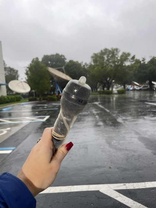
Posted on 9/29/22 at 9:39 am to stout
Tweet
See new Tweets
Conversation
Jeff Butera
@ABC7Jeff
** WE PRACTICE SAFE HURRICANE REPORTING **
Yes, it's a condom.
Nothing better to waterproof a microphone.
My Waterman Broadcasting colleague
@kylagaler
has been fielding lots of questions, haha.
Moment of levity in this nasty storm...
See new Tweets
Conversation
Jeff Butera
@ABC7Jeff
** WE PRACTICE SAFE HURRICANE REPORTING **
Yes, it's a condom.
Nothing better to waterproof a microphone.
My Waterman Broadcasting colleague
@kylagaler
has been fielding lots of questions, haha.
Moment of levity in this nasty storm...
Posted on 9/29/22 at 9:39 am to Oates Mustache
And empty refrigerators/freezers.
Posted on 9/29/22 at 9:39 am to roadGator
Downtown Charleston floods with light rain sometimes, some streets with no rain and just high tide. I was already leaving town tomorrow for a concert in Charlotte, so I’ll personally be out of danger, but hopefully it won’t be too bad.
Posted on 9/29/22 at 9:40 am to FLBooGoTigs1
GTFO
Posted on 9/29/22 at 9:40 am to MorbidTheClown
quote:
1 of 375 ever made P1 Mclarens
Will have an "In Tow" sign on it as it heads to Mexico soon.

 Page 424 of 465

Popular
Back to top