- My Forums
- Tiger Rant
- LSU Recruiting
- SEC Rant
- Saints Talk
- Pelicans Talk
- More Sports Board
- Fantasy Sports
- Golf Board
- Soccer Board
- O-T Lounge
- Tech Board
- Home/Garden Board
- Outdoor Board
- Health/Fitness Board
- Movie/TV Board
- Book Board
- Music Board
- Political Talk
- Money Talk
- Fark Board
- Gaming Board
- Travel Board
- Food/Drink Board
- Ticket Exchange
- TD Help Board
Customize My Forums- View All Forums
- Show Left Links
- Topic Sort Options
- Trending Topics
- Recent Topics
- Active Topics
Started By
Message
re: Ian Observation Thread (Storm Track and Radar inside)
Posted on 9/26/22 at 1:31 pm to gatorsimz

Posted on 9/26/22 at 1:31 pm to gatorsimz
quote:
wouldn't that be more like wed night/early thurs?
Hard to tell, but it seems pretty consistent with the slow-moving GFS positioning during that timeframe.
Honestly, the erotic nature of it threw me so much, it was hard to focus on details.
 1
1

Posted on 9/26/22 at 1:32 pm to LegendInMyMind
quote:
You're in that tricky/uncomfortable phase where you're going to have to explain to your family that you're getting your info and updates from a thread on the OT at a place called Tiger Droppings. They may ask for a link to check out the source themselves. Don't give it to them, it is for the best.
shite, accidentally downvoted this post. Forgive me.
Posted on 9/26/22 at 1:33 pm to Cosmo
quote:
12z HMON would be an absolute disaster for tampa
That isnt the first model ive said the same about this afternoon.
Posted on 9/26/22 at 1:33 pm to Bengalbio
quote:
accidentally downvoted
Refresh the page, upvote his post, refresh again.
Posted on 9/26/22 at 1:33 pm to OysterPoBoy
There is a cone.
Posted on 9/26/22 at 1:34 pm to Ronb
quote:
There is a cone.
waffle or sugar?

Posted on 9/26/22 at 1:34 pm to Bobby OG Johnson
quote:
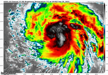
Philip Klotzbach
@philklotzbach
·
24m
#Ian continues to strengthen and now has maximum sustained winds of 85 mph - the strongest September #hurricane in the western (west of 75°W) Caribbean since Ike (2008).
This post was edited on 9/26/22 at 1:39 pm

Posted on 9/26/22 at 1:35 pm to LSUJuice
The rain is going to absolutely frick some of the homes in surrounding neighborhoods like Shore Acres and whatnot. Streets and yards flood during bad thunderstorms.

Posted on 9/26/22 at 1:37 pm to Ronb
That's a pretty good cone. Thanks goodness for the Lord's fan blowing this thing away from LA.
Posted on 9/26/22 at 1:39 pm to OysterPoBoy
quote:

Posted on 9/26/22 at 1:39 pm to gaetti15
quote:
waffle or sugar?
Are you insane?
Obviously, waffle.
Posted on 9/26/22 at 1:43 pm to LegendInMyMind
quote:
I must not be communist enough. It says the site can't be reached.
Oops. My bad. The communist run site can't take more than 2 users at a time. You can do this hour and I will try again later.
This post was edited on 9/26/22 at 1:44 pm
Posted on 9/26/22 at 1:53 pm to ReauxlTide222
And the euro lines up with the GFS this afternoon. On the scenario I was hoping itd avoid.
Posted on 9/26/22 at 2:04 pm to Duke
quote:
And the euro lines up with the GFS this afternoon. On the scenario I was hoping itd avoid.
Amazing how far apart they were last week and now almost identical tracks.

Posted on 9/26/22 at 2:07 pm to SippyCup
quote:
quote:
And the euro lines up with the GFS this afternoon. On the scenario I was hoping itd avoid.
Amazing how far apart they were last week and now almost identical tracks.
I mean, it sort of makes sense that eventually more and more of the unknown variables will start to fall into place.
Posted on 9/26/22 at 2:07 pm to Duke
quote:
And the euro lines up with the GFS this afternoon. On the scenario I was hoping itd avoid.
That stall seems very concerning.
Posted on 9/26/22 at 2:11 pm to Bobby OG Johnson
Ocean Heat Content
quote:

Posted on 9/26/22 at 2:12 pm to Bobby OG Johnson
quote:
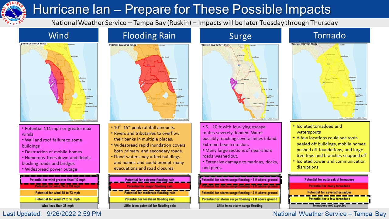
NWS Tampa Bay
@NWSTampaBay
PREPARE NOW for Hurricane #Ian!
What should you prepare for?
* Hurricane/TS conditions depending where you are
* Widespread flooding 10-15 in. near the coast
* 5-10 ft storm surge
* A few tornadoes possible
Should be wrapping up preparation by Tuesday afternoon!

Posted on 9/26/22 at 2:13 pm to ReauxlTide222
quote:
Never one that has shot straight into Tampa Bay. Been in a ton of big storms but almost all of them in central florida.
Tampa/St. Pete dodged a huge bullet in 2004 when Charley rapidly intensified and took a last minute turn into Punta Gorda. At the time it was a top 10 in strongest hurricanes to make landfall in the US.

Posted on 9/26/22 at 2:13 pm to Bobby OG Johnson
Friends in Seminole and St Pete’s Beach are preparing to leave.

 Page 174 of 465

Popular
Back to top