- My Forums
- Tiger Rant
- LSU Recruiting
- SEC Rant
- Saints Talk
- Pelicans Talk
- More Sports Board
- Fantasy Sports
- Golf Board
- Soccer Board
- O-T Lounge
- Tech Board
- Home/Garden Board
- Outdoor Board
- Health/Fitness Board
- Movie/TV Board
- Book Board
- Music Board
- Political Talk
- Money Talk
- Fark Board
- Gaming Board
- Travel Board
- Food/Drink Board
- Ticket Exchange
- TD Help Board
Customize My Forums- View All Forums
- Show Left Links
- Topic Sort Options
- Trending Topics
- Recent Topics
- Active Topics
Started By
Message
re: Hurricane/Tropical Storm Idalia Discussion Thread
Posted on 8/29/23 at 4:15 pm to Captain Want
Posted on 8/29/23 at 4:15 pm to Captain Want
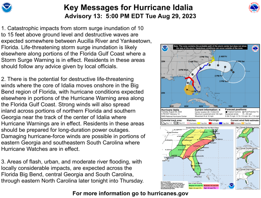
5 PM ET NHC track update is nudged 25 miles to the west, but further adjustments could be necessary.
Tallahassee = keep an eye on Idalia into overnight hours!

Tallahassee = keep an eye on Idalia into overnight hours!
 2
2


Posted on 8/29/23 at 4:16 pm to Duke
quote:

What is this chart? Can you please explain? Thanks.
Posted on 8/29/23 at 4:16 pm to CobraCommander83
quote:
every time TWC mentions surge or rapid intensification
Not watching TWC, but have they done that stupid computer animation for what a 10 foot storm surge would look like?
Posted on 8/29/23 at 4:16 pm to Captain Want
quote:
I'm wondering whether this will affect the LSU-Florida State game.
Game is not in Tallahassee and Orlando should be fine by Sunday
Posted on 8/29/23 at 4:18 pm to Lokistale
quote:
but have they done that stupid computer animation for what a 10 foot storm surge would look like?
Several times
Posted on 8/29/23 at 4:19 pm to Athis
quote:
Damn glad that Franklin is headed out to sea.. 125MPH 947 MB right now..
It is weakening. It was in the 920s yesterday.
Posted on 8/29/23 at 4:19 pm to Hangit
quote:
Right above you, at Fort Pierce is gusting 15mph
Here in Melbourne we're getting hammered by the first outer band at the moment.

Posted on 8/29/23 at 4:20 pm to Duke
quote:
Always read the discussion. The forecast times aren't catching the max. They still are forecasting a 125 mph max.
Ah, good point, thanks for pointing that out.
Posted on 8/29/23 at 4:21 pm to OU Guy
Hurricane Tracker App
@hurrtrackerapp
Yellow track is the 11AM EDT track and the blue track is the new one just updated at 5PM EDT. Red line is a hurricane warning. Tallahassee is just outside the western edge of the cone. Keep an eye on the next couple forecasts if you are in the Tallahassee region

@hurrtrackerapp
Yellow track is the 11AM EDT track and the blue track is the new one just updated at 5PM EDT. Red line is a hurricane warning. Tallahassee is just outside the western edge of the cone. Keep an eye on the next couple forecasts if you are in the Tallahassee region
Posted on 8/29/23 at 4:26 pm to bodean45
quote:
Game is not in Tallahassee and Orlando should be fine by Sunday
Disney is open today and tomorrow. Disney is aboot 10 miles from Orlando, and 15 from the stadium. The cane will be gone.
Posted on 8/29/23 at 4:26 pm to OU Guy
Keep in mind the blue line is just connecting the dots. The curved line the storm will follow will actually bring it closer to Tallahassee. Looks like landfall might be near the Aucilla River now.
Also, 100 pages!
Also, 100 pages!
Posted on 8/29/23 at 4:29 pm to Hangit
Largo had a gust to 34 in the first band, but been quiet since.
Posted on 8/29/23 at 4:31 pm to RockChalkTiger
National Hurricane Center
@NHC_Atlantic
5PM EDT 29 Aug: #Idalia to bring catastrophic impacts from storm surge inundation . Residents in these areas should follow any advice or evacuation orders given by local officials. Make sure to stay informed with latest updates at LINK

Posted on 8/29/23 at 4:32 pm to RockChalkTiger
quote:
. Looks like landfall might be near the Aucilla River now.
sparsely populated area. do feel for the awesome flora and fauna of that area though.
This post was edited on 8/29/23 at 4:33 pm

Posted on 8/29/23 at 4:33 pm to Fishwater
Posted on 8/29/23 at 4:33 pm to OU Guy
That cone is looking healthy.
Posted on 8/29/23 at 4:34 pm to RollTide1987
I flew on P-3 Orion's in the Navy back in the 70's and early 80's....That plane was a workhorse and one of the toughest in the Navy fleet.
Posted on 8/29/23 at 4:37 pm to RockChalkTiger
quote:Those funbags would make a bishop kick out a stained glass window
They couldn’t get Stephanie Abrams a shirt with buttons that work?
Posted on 8/29/23 at 4:37 pm to OU Guy
quote:
OU Guy
Since this is a weather thread, in my mind you are Phillip Seymour Hoffman in Twister.
Posted on 8/29/23 at 4:38 pm to gladchiefisgone
quote:
P-3 Orion
On station, we would shut down one engine and feather the prop to save gas—that’s how much extra power it has. And built like a tank. The P-8 (737) has a much faster on-station time, but the P-3 is much more rugged!

 Page 100 of 139

Popular
Back to top