- My Forums
- Tiger Rant
- LSU Recruiting
- SEC Rant
- Saints Talk
- Pelicans Talk
- More Sports Board
- Fantasy Sports
- Golf Board
- Soccer Board
- O-T Lounge
- Tech Board
- Home/Garden Board
- Outdoor Board
- Health/Fitness Board
- Movie/TV Board
- Book Board
- Music Board
- Political Talk
- Money Talk
- Fark Board
- Gaming Board
- Travel Board
- Food/Drink Board
- Ticket Exchange
- TD Help Board
Customize My Forums- View All Forums
- Show Left Links
- Topic Sort Options
- Trending Topics
- Recent Topics
- Active Topics
Started By
Message
 1
1

Posted on 9/27/24 at 11:36 pm to Oates Mustache
quote:
Some old skank that tried to attention whore the hurricane thread
You sure have given her the attention, Otis.
Posted on 9/27/24 at 11:39 pm to tigersownall
Geoengineered gonna geoengineered

Posted on 9/28/24 at 12:02 am to LegendInMyMind
Wat? Dude asked a question. Plus, I didn't photoshop her flapjacks onto a blue shed. 
You take that shite back.
You take that shite back.

Posted on 9/28/24 at 12:09 am to Oates Mustache
Someone turn off the GD hurricane machine. This is getting old

Posted on 9/28/24 at 12:13 am to rds dc

Please no not another one.
This post was edited on 9/28/24 at 12:16 am
Posted on 9/28/24 at 12:45 am to Rize
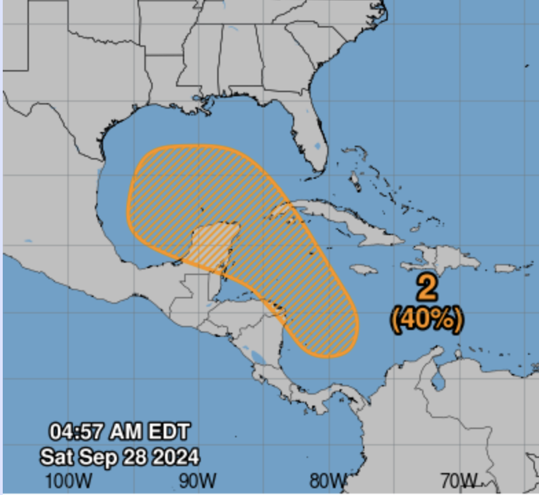
Western Caribbean Sea and Gulf of Mexico:
An area of low pressure could form over the western Caribbean Sea by
the early part of next week. Environmental conditions are expected
to be conducive for additional development thereafter while the
system moves generally northwestward, and a tropical depression
could form by the middle of next week as the system enters the Gulf
of Mexico.
* Formation chance through 48 hours...low...near 0 percent.
* Formation chance through 7 days...medium...40 percent.
Posted on 9/28/24 at 12:46 am to lsuman25
40% = 100% in NHC math
This post was edited on 9/28/24 at 12:46 am

Posted on 9/28/24 at 12:48 am to Cosmo
Bingo card needs Blue House and 36DDD’s in hubby’s face
Also something about GRAF
Also something about GRAF
This post was edited on 9/28/24 at 12:52 am

Posted on 9/28/24 at 4:40 am to Cosmo
you forgot the 38DDDDDs pic
Posted on 9/28/24 at 4:51 am to rds dc
Up to 40% now per NHC 9/28/24 5 am outlook.
Posted on 9/28/24 at 5:51 am to otowntiger
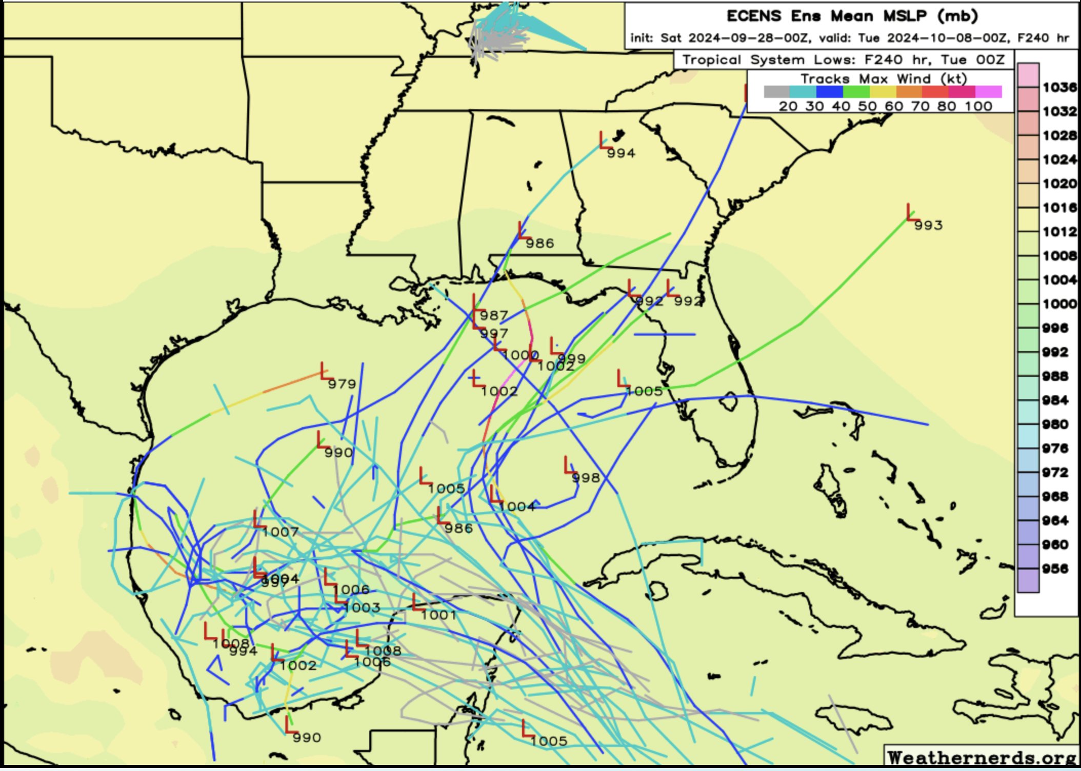
Obviously too early to know for sure, but GFS is not showing very powerful storm

Posted on 9/28/24 at 5:54 am to Cosmo
Oh frick off...ugh
ETA: not directed at you but this weather
ETA: not directed at you but this weather
This post was edited on 9/28/24 at 7:50 am
Posted on 9/28/24 at 6:03 am to GEAUXT
GFS is showing a Cat 1 basically dragging across Plaquemines parish and then across Mississippi and Alabama coasts. Euro isn’t showing much more than a big rainmaker across the entire central and eastern gulf.
Posted on 9/28/24 at 6:06 am to rds dc
When is this supposed to be?
Posted on 9/28/24 at 6:19 am to fr33manator
Saturday-ish
Posted on 9/28/24 at 6:30 am to BurningHeart
The number next to that eggplant-shaped penis keeps going higher.

Posted on 9/28/24 at 6:56 am to Gee Grenouille
quote:
TROPICS: An area of low pressure could form over the western Caribbean Sea by the early part of next week. Environmental conditions are expected to be conducive for additional development thereafter while the system moves generally northwestward, and a tropical depression could form by the middle of next week as the system enters the Gulf of Mexico.
NHC now shows a 40 percent chance of development over the next seven days.
A few notes...
*There is no skill at forecasting the placement or intensity of a tropical cyclone 7 days in advance.
*For ideas, you don't look at deterministic model output, but ensemble output, which shows the range of possibilities.
*I have attached ensemble output from the reliable European global model to this post, which shows a huge spread if a system develops, and expresses clearly the uncertainty.
*There has been some upwelling in association with Hurricane Helene over the southern and eastern Gulf of Mexico, meaning cooler sea surface temperatures.
*If you have a beach trip planned, there is absolutely no need to change any plans now. Just watch for updates.
Loading Twitter/X Embed...
If tweet fails to load, click here.
Posted on 9/28/24 at 6:57 am to Gee Grenouille
In cold fronts we trust
Posted on 9/28/24 at 7:02 am to LSUJML
quote:
That’s about right, day of my outdoor wedding
Outer bands gonna blow harder than your future wife ever would

 Page 5 of 242

Popular
Back to top