- My Forums
- Tiger Rant
- LSU Recruiting
- SEC Rant
- Saints Talk
- Pelicans Talk
- More Sports Board
- Fantasy Sports
- Golf Board
- Soccer Board
- O-T Lounge
- Tech Board
- Home/Garden Board
- Outdoor Board
- Health/Fitness Board
- Movie/TV Board
- Book Board
- Music Board
- Political Talk
- Money Talk
- Fark Board
- Gaming Board
- Travel Board
- Food/Drink Board
- Ticket Exchange
- TD Help Board
Customize My Forums- View All Forums
- Show Left Links
- Topic Sort Options
- Trending Topics
- Recent Topics
- Active Topics
Started By
Message
re: Hurricane Irma - Spinning Down
Posted on 9/7/17 at 11:09 am to cajunangelle

Posted on 9/7/17 at 11:09 am to cajunangelle

 1
1


Posted on 9/7/17 at 11:09 am to rt3
quote:yeah, it reverted back to a few models ago sparing NC from the right side of the Irma beast. I keep hearing Jose may come in and slam NC.
2nd potential US landfall right at the GA/SC border in this run... maybe a bit more south into GA
This post was edited on 9/7/17 at 11:10 am
Posted on 9/7/17 at 11:10 am to slackster
Does the 12z GFS have it hitting Atlanta as a CAT 1?
Posted on 9/7/17 at 11:10 am to cajunangelle
I would have to think that Jose will be shipped out to sea?

Posted on 9/7/17 at 11:10 am to cajunangelle

RT3 UP THE PUCKER LEVEL BAW
Posted on 9/7/17 at 11:10 am to jimbeam
High tide vs. low tide is one thing. What tends to be forgotten is the water pushed ahead of the storm, that is there and that tide is added to.
I don't think the Katrina problems have ever been addressed. The Wolf river in back of the inner barrier islands in Mississippi had water pushed into it, and then more from Katrina...and that lead to (you guessed it) flooding where it had never flooded before.
Pontchartrain had a massive accumulation of water even through the eye passed over miles to the east. Remember how so many of our friends breathed a sigh of relief the day after the storm, and THEN the levees broke. Not from the storm but from structural weakness (substructural weakness for 17th st canal).
There are some inlets in Florida that have similar patterns for potential problems. That's unavoidable because of the nature of the islands and inland swamps that came before people.

Posted on 9/7/17 at 11:11 am to GetCocky11

Posted on 9/7/17 at 11:12 am to GetCocky11
quote:they evacuated for Matthew. so Irma is a no-brainer evac.
2nd potential US landfall right at the GA/SC border in this run... maybe a bit more south into GA
I'll worry if the Marines evacuate Parris Island.
Posted on 9/7/17 at 11:12 am to real turf fan

Posted on 9/7/17 at 11:12 am to jackmanusc
quote:
That does not look good, though my neighborhood didn't flood with Matthew or the 100 year floods. If I'm going to lose it all though, I just hope the winds destroy my house before the flooding does. Then insurance will cover me.

Posted on 9/7/17 at 11:13 am to PsychTiger
quote:
That does not look good, though my neighborhood didn't flood with Matthew or the 100 year floods. If I'm going to lose it all though, I just hope the winds destroy my house before the flooding does. Then insurance will cover me.
All the crazy development in Charleston since 1989. Tons of vulnerable areas.
Posted on 9/7/17 at 11:16 am to 50_Tiger
quote:
RT3 UP THE PUCKER LEVEL BAW

Posted on 9/7/17 at 11:17 am to rt3
Posted on 9/7/17 at 11:18 am to GetCocky11
Yes, and Sunny Point ammo north of Charleston. A lot of military in the Carolinas, more so than I ever knew.
Posted on 9/7/17 at 11:19 am to rt3
Posted on 9/7/17 at 11:19 am to ForeverGator
quote:
The I-75 corridor after I-75 and the Turnpike merge is a log jam.

Lots of slow moving traffic everywhere. I'd imagine, with as many people that are evacuating, Atlanta traffic may get even worse. A lot of people evacuating from Savannah will probably head this way.
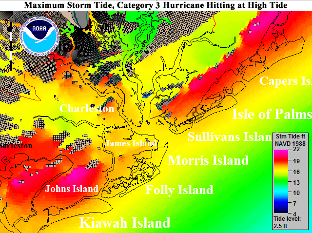
Posted on 9/7/17 at 11:19 am to TheGasMan
quote:
TheGasMan
From that picture what would you project the outcome to be for Johns Island around the area of Maybank and Main?
Posted on 9/7/17 at 11:20 am to Wildcat In Germany
quote:
Lots of slow moving traffic everywhere. I'd imagine, with as many people that are evacuating, Atlanta traffic may get even worse. A lot of people evacuating from Savannah will probably head this way.
good thing they fixed that bridge that the crackhead burned down
Posted on 9/7/17 at 11:20 am to cajunangelle
Nuke school is in Goose Creek, SC. Probably 1500 military personnel there plus other various installations around Charleston.
Posted on 9/7/17 at 11:20 am to cajunangelle
quote:
I keep hearing Jose may come in and slam NC.
Jose is a long ways off from impacting the US mainland, if it does at all. Might not be a bad idea to keep the conversation in this thread about Irma to prevent any confusion.
This post was edited on 9/7/17 at 11:24 am

 Page 355 of 711

Popular
Back to top