- My Forums
- Tiger Rant
- LSU Recruiting
- SEC Rant
- Saints Talk
- Pelicans Talk
- More Sports Board
- Fantasy Sports
- Golf Board
- Soccer Board
- O-T Lounge
- Tech Board
- Home/Garden Board
- Outdoor Board
- Health/Fitness Board
- Movie/TV Board
- Book Board
- Music Board
- Political Talk
- Money Talk
- Fark Board
- Gaming Board
- Travel Board
- Food/Drink Board
- Ticket Exchange
- TD Help Board
Customize My Forums- View All Forums
- Show Left Links
- Topic Sort Options
- Trending Topics
- Recent Topics
- Active Topics
Started By
Message


 0
0


Posted on 9/27/22 at 1:46 pm to Hangit
The limit does not exist

Posted on 9/27/22 at 1:48 pm to H2O Tiger
Homewood Suites. It only costs me Hilton points and we have stayed at a couple of them with the dogs.

Posted on 9/27/22 at 1:48 pm to kywildcatfanone
quote:Thats what I’m thinking
Good time to aerate your yard and overseed.

Posted on 9/27/22 at 1:50 pm to Aspercel
quote:
The limit does not exist


Posted on 9/27/22 at 1:50 pm to RummelTiger
quote:
I would just ask for some water and wait for actual help.
I would pelt him with rocks and shingles until he moved on.

Posted on 9/27/22 at 1:50 pm to TheFonz
quote:
To any of y'all in the path and staying, all I can say is reconsider. I stayed for Ida and still have PTSD from that mutha. You'll be hearing some scary shite in the dark and those sounds will be in your head forever.
Not to mention that area hasnt seen a hurricane like this in 100 years......their power poles, grid, trees, houses and trailer parks are going to be absolutely destroyed.
Life is going to suck for a lot of people for a very long time.
Hopefully they have some cruise ships on standby along with floating hospitals.
Posted on 9/27/22 at 1:51 pm to LewDawg
BTW, some or most of you probably have seen this but here's a Sea Level Viewer that is interactive. You can punch in a storm surge up to 10' to see how it affects the area.

Posted on 9/27/22 at 1:51 pm to LewDawg

Posted on 9/27/22 at 1:51 pm to VABuckeye
quote:
Right now I am leaning heavily towards going but we do have some time to watch the forecast. The drive to Miami right now is only about 15 minutes longer than normal so that isn't a huge concern yet.
I’m right on the other side of the alley. More traffic than usual obviously but not bad
Posted on 9/27/22 at 1:53 pm to tgrbaitn08
We have friends in Port Charlotte close to the water that are staying. Feel they’re going to be alright because their home is 10 feet above sea level. I think they’re nuts and it isn’t worth the risk.

Posted on 9/27/22 at 1:54 pm to VABuckeye
Dang, a 4-5' surge puts the Naples airport underwater.
THough that seems like an overall rise in sea levels and not a storm surge calculator. The wind driven water will probably go in further than a steady, slow rise.
THough that seems like an overall rise in sea levels and not a storm surge calculator. The wind driven water will probably go in further than a steady, slow rise.
Posted on 9/27/22 at 1:54 pm to Hangit
quote:
For those driving away, I-4 is fooked. Hwy 60 is pretty clear until aboot 15 miles before Yeehaw Junction. Then it comes to a halt.
I was watching maps yesterday and kept
60 was wide open.
Posted on 9/27/22 at 1:55 pm to H2O Tiger
The slower the movement, the more water the surge moves. When it moves water, it also shifts the sediments. Navigation will be iffy at best after the storm.
The Coast Guard will come in and first priority will be making sure the channels are clear (and trying to find the buoys that mark the channels). Clearing houses and boats out of the channels comes next about the same time as folks will come down from Canada to put up temporary bridges.
Moving sand off of highways, trees, houses, single and the halves of double wides (after they've been checked for bodies), cars, boats, all have to be moved.
I can only imagine the man the current gubment will appoint, you won't find a General Honore in charge.
Posted on 9/27/22 at 1:57 pm to C-Bear
quote:
We have friends in Port Charlotte close to the water that are staying. Feel they’re going to be alright because their home is 10 feet above sea level.
What are their plans when the roof blows off and the walls cave in?

Posted on 9/27/22 at 1:57 pm to OldCityGator
quote:
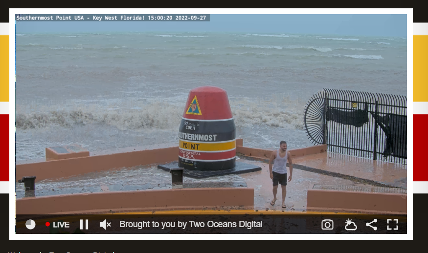
Key West Southernmost Point Webcam
SIAP but this one could get spicy to watch as Ian moves closer
It looks like it is getting pretty rough already. Let's see how long those black tarp things stay on that fence.

Posted on 9/27/22 at 1:57 pm to H2O Tiger
Anybody have an exact line where they have landfall now

Posted on 9/27/22 at 1:57 pm to tgrbaitn08
THICC

Posted on 9/27/22 at 1:59 pm to OldCityGator
quote:
Key West Southernmost Point Webcam
Which poster is that out there in his wife beater posing for pictures?
This post was edited on 9/27/22 at 2:02 pm
Posted on 9/27/22 at 2:00 pm to Festus


 Page 233 of 465

Popular
Back to top