- My Forums
- Tiger Rant
- LSU Recruiting
- SEC Rant
- Saints Talk
- Pelicans Talk
- More Sports Board
- Fantasy Sports
- Golf Board
- Soccer Board
- O-T Lounge
- Tech Board
- Home/Garden Board
- Outdoor Board
- Health/Fitness Board
- Movie/TV Board
- Book Board
- Music Board
- Political Talk
- Money Talk
- Fark Board
- Gaming Board
- Travel Board
- Food/Drink Board
- Ticket Exchange
- TD Help Board
Customize My Forums- View All Forums
- Show Left Links
- Topic Sort Options
- Trending Topics
- Recent Topics
- Active Topics
Started By
Message
re: Hurricane Florence - Catastrophic Flooding Potential
Posted on 9/13/18 at 12:53 pm to Drank

Posted on 9/13/18 at 12:53 pm to Drank
quote:
Naw you just have to refresh the page when it goes black
It's a different one on Surfline and that one is down
Are yall sure the Bogue one that goes black isn't a loop? I tried to watch it a few times and couldn't tell. It definitely keeps panning on a schedule or something.
 2
2


Posted on 9/13/18 at 12:54 pm to slackster
I was thinking about the storm moving south to north lol

Posted on 9/13/18 at 12:54 pm to 9Fiddy
If you told me yesterday that I'd willingly stare at a video of a flag blowing in the wind all day today, I'd have told you to frick right off.
Yet here I am.
Yet here I am.
This post was edited on 9/13/18 at 12:55 pm
Posted on 9/13/18 at 12:55 pm to Who_Dat_Tiger
quote:
M4 Media?I've seen better oceans in the quad.
Whoever this is

Posted on 9/13/18 at 12:55 pm to Pettifogger
Went to take a leak. I see that shite got real at Frying Pan Shoals!
Posted on 9/13/18 at 12:55 pm to X123F45
From Wikipedia, the free encyclopedia
Frying Pan Shoals Light
Location
North Carolina
Coordinates
33°29'N 77°35'W
Year first constructed
1964
Automated
1979
Deactivated
2003
Foundation
Steel
Height
80 ft (24 m)
Fog signal
Fog horn
ARLHS number
USA-313
[edit on Wikidata]
Frying Pan Shoals Light Tower is a decommissioned lighthouse located approximately 39 miles (63 km) southeast of Southport, North Carolina and 32 miles (51 km) from Bald Head Island, North Carolina.[1] The light tower is modeled after a steel oil drilling platform, known as a “Texas tower” on top of four steel legs that was engineered to be used as a lighthouse housing several Coast Guard members. The 80-foot (24 m) light tower marks the shoals at the confluence of the Cape Fear River and the Atlantic Ocean.[2] The platform consists of two floors. The subfloor is a living area of approximately 5,000 square feet (460 m2) that includes seven bedrooms, kitchen, office, storage area, recreation area and toilet facilities.[citation needed]
The light tower is accessible by helicopter and by boat. A January 2010 onsite inspection by an engineering firm that was contracted by the Coast Guard determined that the helipad platform can indeed support a helicopter and that the entire structure, while in need of repair, was 'structurally sound'.[3][dead link] The lower stairs to the light tower were destroyed by a hurricane and the mid to upper section stairs have experienced significant deterioration due to the salt environment.
The tower was replaced by a buoy in 2003 and no longer serves as an aid to navigation but due to the structure attracting a wide range of aquatic life, it is an oft visited site for fishermen and divers. The Coast Guard considered demolishing the light for use as an artificial reef, but instead held an online auction where the winning bid was by a South Carolina diving and research firm Shipwrecks, Inc. in 2009 for $515,000.[2] However, the company failed to make the down-payment[4] and subsequently, the tower returned to government hands and was sold again in August 2010 for $85,000 to a private individual, Richard Neal of Charlotte, North Carolina.[5] Neal, with the aid of volunteers, has refurbished the light, converting it into a "bed-and-breakfast for the adventurous", with accommodation for up to eight. The facility is now open for paying guests.[6]
Posted on 9/13/18 at 12:55 pm to tiger91
That pier is taking a beating. Those lights sure are moving a lot.
Posted on 9/13/18 at 12:56 pm to Pettifogger
If anyone else has Surfline access the Frisco Beach cam is directly on the beach and should show the surge pretty clearly as it comes up (if it stays live)

Posted on 9/13/18 at 12:57 pm to tgrbaitn08
quote:
what is cam 8?
The Ocho.
Posted on 9/13/18 at 12:57 pm to Geaux23
Frying Pan cam is getting dark out there
Peir is taking a beating
Peir is taking a beating
Posted on 9/13/18 at 12:58 pm to NorthEndZone
Flag pole starting to shake pretty good.
Another OT tigerdroppings shout out .
.
Another OT tigerdroppings shout out
Posted on 9/13/18 at 12:59 pm to tgrbaitn08
Posted on 9/13/18 at 1:00 pm to tgrbaitn08
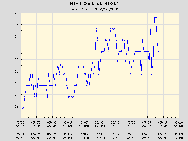
Buoy 41037 at 33.99N 77.36W is gusting near 70 mph
Posted on 9/13/18 at 1:00 pm to tiger91

Posted on 9/13/18 at 1:03 pm to tiger91
Still high and dry.
Posted on 9/13/18 at 1:03 pm to tiger91
quote:
Getting really dark where those 200 people chose to stay
damn thing is down for me. must be overloaded

Posted on 9/13/18 at 1:03 pm to NorthEndZone
Storms a Cat 2 now? Weak.
Posted on 9/13/18 at 1:03 pm to tiger91
quote:
Getting really dark where those 200 people chose to stay
The looters are a little early
Posted on 9/13/18 at 1:04 pm to Mountaineerfan7
Some tasty waves for sure. Wouldn't want to be on that Pier.

Posted on 9/13/18 at 1:04 pm to tiger91
Our Baw Jeff trying to find a good spot to go through the storm

 Page 295 of 400

Popular
Back to top