- My Forums
- Tiger Rant
- LSU Recruiting
- SEC Rant
- Saints Talk
- Pelicans Talk
- More Sports Board
- Fantasy Sports
- Golf Board
- Soccer Board
- O-T Lounge
- Tech Board
- Home/Garden Board
- Outdoor Board
- Health/Fitness Board
- Movie/TV Board
- Book Board
- Music Board
- Political Talk
- Money Talk
- Fark Board
- Gaming Board
- Travel Board
- Food/Drink Board
- Ticket Exchange
- TD Help Board
Customize My Forums- View All Forums
- Show Left Links
- Topic Sort Options
- Trending Topics
- Recent Topics
- Active Topics
Started By
Message
re: Hurricane Florence - Catastrophic Flooding Potential
Posted on 9/13/18 at 12:29 pm to Who_Dat_Tiger

Posted on 9/13/18 at 12:29 pm to Who_Dat_Tiger
The frying pan buoy is nearby.
33.436 N 77.743 W
(33°26'11" N 77°44'35 W
33.436 N 77.743 W
(33°26'11" N 77°44'35 W
 1
1

Posted on 9/13/18 at 12:30 pm to LSU Patrick
quote:
Frying pan about to get nailed.

Posted on 9/13/18 at 12:30 pm to slackster
nevermind im an idiot
This post was edited on 9/13/18 at 12:31 pm

Posted on 9/13/18 at 12:30 pm to Who_Dat_Tiger
quote:
anyone know the exact coordinates of the Frying Pan webcam?
33°29'N 77°35'W

Posted on 9/13/18 at 12:30 pm to Ace Midnight
quote:
You know, it is a hurricane, right baw?

Posted on 9/13/18 at 12:30 pm to NorthEndZone
quote:
33.483N 77.583W
Frying Pan is 97 miles due west of Florence's current location.

Posted on 9/13/18 at 12:31 pm to LSUvegasbombed
Partly cloudy here in Charleston, doing yard work today since I took leave from work.

Posted on 9/13/18 at 12:31 pm to LSU Patrick
quote:
Is that the eye in the upper left of the flag cam?
The eye is over 75 miles from flag cam right now based on the coordinates of the platform and the latest position for Florence from the NHC. Winds are out of the NNW at the buoy near flag cam, so based on the position of the flag, that camera is looking Eastish. Florence is due East of the platform, so the eye IS probably somewhere in the general direction of that light patch, WAY over the horizon. That grey probably is the outside of the core of the storm where the fun REALLY starts going down, though.
ETA: fat fingered a coordinate. 75 miles, not 400.
ETATA: Whoever was looking for the coordinates of the frying pan earlier: 33°29'N 77°35'W
This post was edited on 9/13/18 at 12:41 pm

Posted on 9/13/18 at 12:32 pm to slackster
Pretty sure the grey on the right of the horizon is Flo's core.
Posted on 9/13/18 at 12:32 pm to Geaux23
quote:
nevermind im an idiot
We can't see the east side of the storm on radar right now, but there is plenty of rain out there.
Posted on 9/13/18 at 12:33 pm to 50_Tiger
quote:
Pretty sure the grey on the right of the horizon is Flo's core.
Not sure which direction the cam at the Frying Pan is facing, but the winds should start shifting to out of the north if they haven't already.
Posted on 9/13/18 at 12:34 pm to Ghost of Colby
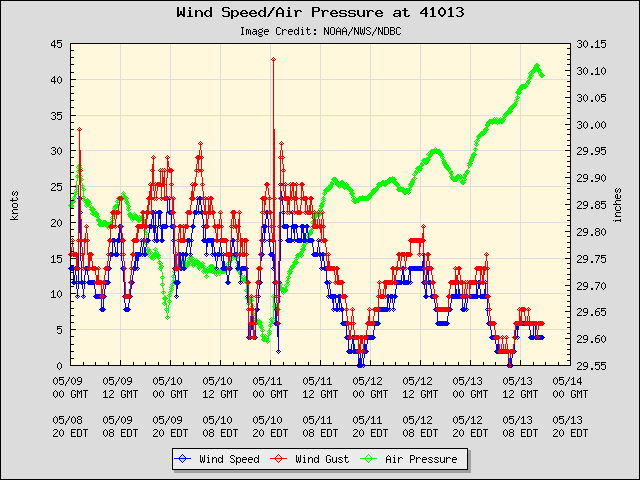
Buoy 41013 is 8 nautical miles from Frying Pan Cam...highest gust 56 mph so far. It will get much worse. And that is the 'weak' quadrant of Flo.

Posted on 9/13/18 at 12:34 pm to 9Fiddy
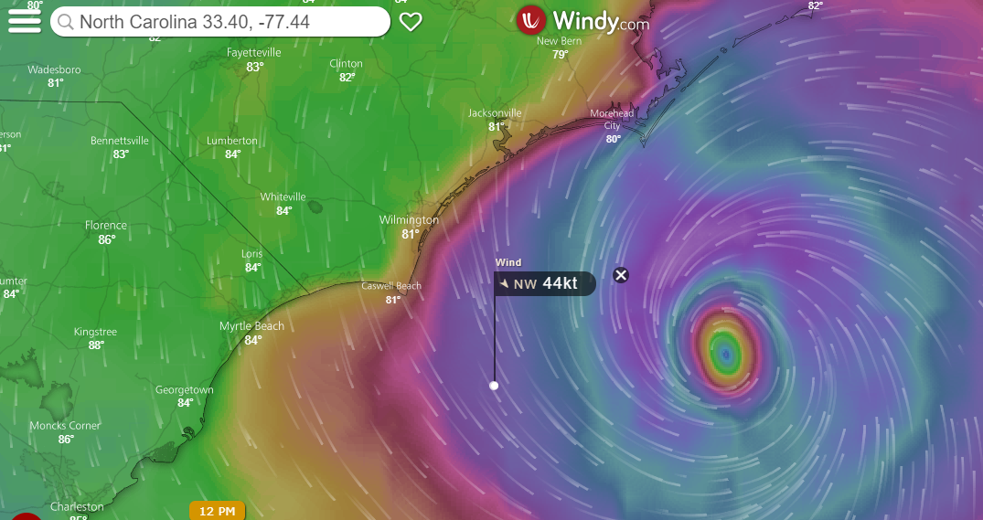
So this is the general area of the Frying Pan webcam
Posted on 9/13/18 at 12:35 pm to LSUBoo
quote:
Up to 200 people decided to stay on Ocracoke Island, NC. There is no road to the island, ferry service has now stopped, emergency response has now stopped. They have decided to stay on an island that might go underwater. Don't be that person.
Average elevation of the island is 5'. High points are barely more than 10' above sea level.
Did I see numbers like 20' associated with the surge, or was I misinterpreting something? Maybe at a different point?
20 feet of water on a 10 foot property doesn't sound good.
Posted on 9/13/18 at 12:36 pm to Who_Dat_Tiger
I bet that camera is pointed NE because you can still see that dry air.
Posted on 9/13/18 at 12:38 pm to tokenBoiler
LINK
Here's a link to a cam where the 200 people stayed -- it changes views from time to time
Here's a link to a cam where the 200 people stayed -- it changes views from time to time
This post was edited on 9/13/18 at 12:39 pm
Posted on 9/13/18 at 12:38 pm to 50_Tiger
It rotates almost 360 degrees. Last night it appeared to be looking out to see as the sun was setting and I was like wtf?? then remembered it is out of sight of land and was pointed west towards land and the setting sun.

Posted on 9/13/18 at 12:39 pm to 50_Tiger
The oceanana webcam on Surfline is probably the one that is about to start getting the real force of the band, from what I can tell.
Posted on 9/13/18 at 12:41 pm to MountainTiger
That grey area is getting closer and closer though ahaha Frying Pan gonna probably get into the W and E eyewall.

 Page 293 of 400

Popular
Back to top