- My Forums
- Tiger Rant
- LSU Recruiting
- SEC Rant
- Saints Talk
- Pelicans Talk
- More Sports Board
- Fantasy Sports
- Golf Board
- Soccer Board
- O-T Lounge
- Tech Board
- Home/Garden Board
- Outdoor Board
- Health/Fitness Board
- Movie/TV Board
- Book Board
- Music Board
- Political Talk
- Money Talk
- Fark Board
- Gaming Board
- Travel Board
- Food/Drink Board
- Ticket Exchange
- TD Help Board
Customize My Forums- View All Forums
- Show Left Links
- Topic Sort Options
- Trending Topics
- Recent Topics
- Active Topics
Started By
Message

 1
1

Posted on 9/1/19 at 5:31 pm to biggsc
Got a plane in there now. We'll know the answer soon enough.
Posted on 9/1/19 at 5:32 pm to Duke
Yes we will

Posted on 9/1/19 at 5:34 pm to biggsc
I remember seeing the forecast Tuesday saying this thing wouldn’t even make Hurricane. Now it’s going to be one of the strongest on record. That’s absolutely insane.
Posted on 9/1/19 at 5:34 pm to biggsc

Other thing to watch for, as this looks like an outer eyewall that has about wrapped around the center. Going to be looking carefully for a double wind max on recon.

Posted on 9/1/19 at 5:35 pm to MrLSU
Really?
Posted on 9/1/19 at 5:37 pm to GetCocky11
quote:
CNN put a correspondent in Freeport to ride this thing out.
Too bad they didn't let TD pick which one.
Posted on 9/1/19 at 5:40 pm to Duke
quote:
As always, we'll see how the measurements match the imagery this evening.
Recon is inbound. It will have to deal with a slightly bigger island over the next few hours but the waters there and then the Gulf Stream are extremely warm. Also, mixing may not be as big of an issue since the warmth is very warm nearly to the bottom of the column in this area. Another bust of strengthening could be on tap, if there is no ERC.

Posted on 9/1/19 at 5:40 pm to MrLSU

Posted on 9/1/19 at 5:44 pm to MrLSU
Maybe dude saw the radar and said he was gonna die doing something he loves like kayaking in the ocean. People do strange stuff when under catastrophic situations.
This post was edited on 9/1/19 at 5:45 pm
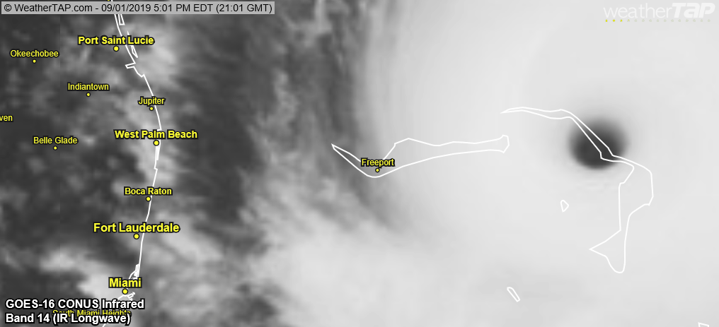
Posted on 9/1/19 at 5:53 pm to slackster
Coopers Town will never be the same. It's catching the eyewall and will never get the actual eye. They've been in the eyewall for over an hour (these images are 70 minutes apart), and they've got 2+ hours to go...


Crown Haven and Fox Town are next up and will likely get it even worse.

Crown Haven and Fox Town are next up and will likely get it even worse.
Posted on 9/1/19 at 5:54 pm to rds dc
Eric Blake made the point earlier but it's amazing this is a current satellite image and most of south Florida isn't all that concerned. Says a lot about the how far we've come in terms of forecasting.

Posted on 9/1/19 at 5:56 pm to Duke
Would be nice to start a NW turn now and spare Freeport. By far the most populated area of those 2 islands getting crushed.
Posted on 9/1/19 at 5:58 pm to rds dc
This storm is insane. Never seen one stay together like this, no weakening with land (island) interaction, no EWRC, thing is just steady feeding.
Beast of a storm and beautiful/fascinating in a terrible way. Pray it doesn’t come on shore and stays away from the Florida coast. This is the type that causes high numbers of casualties
Beast of a storm and beautiful/fascinating in a terrible way. Pray it doesn’t come on shore and stays away from the Florida coast. This is the type that causes high numbers of casualties

Posted on 9/1/19 at 5:59 pm to Cosmo
This hurricane is unreal. Hope it starts that jog north soon

Posted on 9/1/19 at 5:59 pm to GetCocky11
I wish CNN would have sent several of their on-air hosts instead.
Posted on 9/1/19 at 6:00 pm to Duke
quote:
Blake made the point earlier but it's amazing this is a current satellite image and most of south Florida isn't all that concerned. Says a lot about the how far we've come in terms of forecasting.
Let’s say this when it actually misses land. It’s no guarantee the models are correct and a storm this large just missing the turn north by 50 miles can make or break
Posted on 9/1/19 at 6:00 pm to Icansee4miles
quote:
Icansee4miles
Don’t be mad at me baw. Sorry I missed the pickup.
Posted on 9/1/19 at 6:01 pm to Cosmo
quote:
Would be nice to start a NW turn now and spare Freeport. By far the most populated area of those 2 islands getting crushed.
It's expected to miss Freeport with anything catastrophic.

 Page 165 of 263

Popular
Back to top