- My Forums
- Tiger Rant
- LSU Recruiting
- SEC Rant
- Saints Talk
- Pelicans Talk
- More Sports Board
- Fantasy Sports
- Golf Board
- Soccer Board
- O-T Lounge
- Tech Board
- Home/Garden Board
- Outdoor Board
- Health/Fitness Board
- Movie/TV Board
- Book Board
- Music Board
- Political Talk
- Money Talk
- Fark Board
- Gaming Board
- Travel Board
- Food/Drink Board
- Ticket Exchange
- TD Help Board
Customize My Forums- View All Forums
- Show Left Links
- Topic Sort Options
- Trending Topics
- Recent Topics
- Active Topics
Started By
Message
re: Hurricane Dorian - Headed to Canada
Posted on 8/31/19 at 11:01 pm to Mr. Hangover
Posted on 8/31/19 at 11:01 pm to Mr. Hangover
I'm all over the place 
 0
0

Posted on 8/31/19 at 11:16 pm to Will Cover
According to the models and NHC track this thing will miss Florida entirely. Carolinas are another story. It’s amusing all the hub bub on storm2k about the new data and west shifts are certain and then the GFS actually shifts back east.
This post was edited on 8/31/19 at 11:18 pm
Posted on 8/31/19 at 11:17 pm to otowntiger
by "this thing" you mean the eye, right?
Posted on 8/31/19 at 11:20 pm to castorinho
quote:the core of the storm. There will be effects on the coast in the form of beach erosion, some surge flooding as is usual during the passage of strong storms but it will stay pretty well off shore it appears.
by "this thing" you mean the eye, right?
Posted on 8/31/19 at 11:34 pm to otowntiger
The Peej forecast just came out.

Posted on 8/31/19 at 11:37 pm to MrLSU
It was a good run. Nice knowing you all.
Posted on 8/31/19 at 11:49 pm to otowntiger
quote:
the core of the storm. There will be effects on the coast in the form of beach erosion, some surge flooding as is usual during the passage of strong storms but it will stay pretty well off shore it appears.
It's still uncomfortably close to the coast. This is a subtle forecast. Weak steering means small things can have profound changes, especially when 30 some odd miles would make a big difference.
I don't envy the forecasters at the hurricane center on this one.

Posted on 9/1/19 at 12:24 am to rds dc
Posted on 9/1/19 at 12:50 am to League Champs
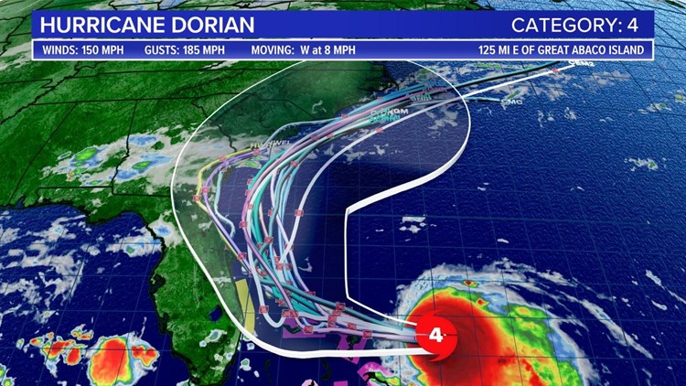
Hurricane Dorian Intermediate Advisory Number 31A
NWS National Hurricane Center Miami FL AL052019
200 AM EDT Sun Sep 01 2019
...EXTREMELY DANGEROUS HURRICANE DORIAN CLOSING IN ON THE
NORTHWESTERN BAHAMAS...
...LIFE-THREATENING STORM SURGE...HURRICANE-FORCE WINDS...AND HEAVY
RAINFALL EXPECTED OVER THE NORTHWESTERNMOST BAHAMAS...
SUMMARY OF 200 AM EDT...0600 UTC...INFORMATION
----------------------------------------------
LOCATION...26.3N 75.6W
ABOUT 95 MI...150 KM E OF GREAT ABACO ISLAND
ABOUT 280 MI...450 KM E OF WEST PALM BEACH FLORIDA
MAXIMUM SUSTAINED WINDS...150 MPH...240 KM/H
PRESENT MOVEMENT...W OR 275 DEGREES AT 8 MPH...13 KM/H
MINIMUM CENTRAL PRESSURE...934 MB...27.58 INCHES

Posted on 9/1/19 at 4:17 am to jlc05
5AM update
Posted on 9/1/19 at 4:17 am to jlc05

I've mentioned it before in these threads but never really got any answers - does the shape of the east coast look like this because of erosion from hurricanes, or does the shape of the east coast (land/water) dictate environmental conditions that typically cause tropical systems to recurve in such a manner?

^ Category 4 and 5 storms since 1851.
Historical storm tracks fit too seamlessly into the shape of the coast from Florida to Virginia for it to simply be a coincidence. I just don't know if it's a chicken or an egg kind of thing.
This post was edited on 9/1/19 at 4:20 am
Posted on 9/1/19 at 4:25 am to slackster


A few photos from last nights mission.
Posted on 9/1/19 at 4:42 am to Will Cover
quote:
most people --- at least from my conversations and observations --- have "relaxed" t
One of my buddies from Cocoa Beach is staying to ride it out. Even inland 5 miles would be 10x better.
Posted on 9/1/19 at 4:43 am to Hangit
The weather in the NW Bahamas will start to go downhill in the next few hours.

Posted on 9/1/19 at 4:49 am to lsuman25

i hope to god this forecast is not correct. but this is what the euro is saying the rainfall will be for freeport, bahamas.
This post was edited on 9/1/19 at 4:51 am
Posted on 9/1/19 at 4:54 am to blight
Unfortunately someone is gonna get slammed with feet of rain most likely.
Posted on 9/1/19 at 4:55 am to Chatagnier
With all of the talk of models shifting slightly west late yesterday, the 5am advisory maintains its eastward trend. What is causing this?

Posted on 9/1/19 at 4:58 am to Dick Jacket
quote:
What is causing this?
Donald Trump

Posted on 9/1/19 at 5:20 am to lsuman25
Those are sweet 
Posted on 9/1/19 at 5:35 am to lsuman25
quote:
The weather in the NW Bahamas will start to go downhill in the next few hours.
Dorian stacked... Da Bahamas fooked.

 Page 137 of 263

Popular
Back to top