- My Forums
- Tiger Rant
- LSU Recruiting
- SEC Rant
- Saints Talk
- Pelicans Talk
- More Sports Board
- Fantasy Sports
- Golf Board
- Soccer Board
- O-T Lounge
- Tech Board
- Home/Garden Board
- Outdoor Board
- Health/Fitness Board
- Movie/TV Board
- Book Board
- Music Board
- Political Talk
- Money Talk
- Fark Board
- Gaming Board
- Travel Board
- Food/Drink Board
- Ticket Exchange
- TD Help Board
Customize My Forums- View All Forums
- Show Left Links
- Topic Sort Options
- Trending Topics
- Recent Topics
- Active Topics
Started By
Message
re: Hurricane Dorian - Headed to Canada
Posted on 8/30/19 at 4:38 pm to FLBooGoTigs1
Posted on 8/30/19 at 4:38 pm to FLBooGoTigs1
Yep. Most of those houses are still for sale after the last two. Just drove down to st Aug a week ago. Those houses won’t be there if that track holds.
A couple were recently sold though. Those owners must be puckering right now.
A couple were recently sold though. Those owners must be puckering right now.
This post was edited on 8/30/19 at 4:39 pm
 0
0

Posted on 8/30/19 at 4:38 pm to roadGator
quote:
That track puts H on top of me. Frick
Better than Motherfricker.
Posted on 8/30/19 at 4:39 pm to Delacroix22
quote:
I always assume a hurricane was being blown off Africa due west with a head of steam and various weather systems just try to knock the trajectory off course as it heads over to the Gulf.
So it's actually like the complete opposite, just taking the path of least resistance due to greater forces around it.
They head west due to the trade winds around the equator, but they want to head north asap due to the Coriolis Effect. The Bermuda high pressure typically keeps them pinned across the Atlantic, but any weakness, due to a trough, will let them through. The flow around a high pressure system in the northern hemisphere is clockwise, so hurricanes will follow it around and that usually gives them their route north and out of the picture.
Posted on 8/30/19 at 4:39 pm to Klingler7
quote:
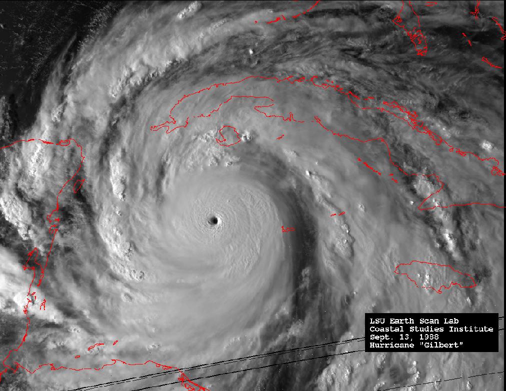
Hurricane Gilbert (1988) was suppose to turn into the upper Texas coast mid September but was said to have been so large that it influenced its own environment and hit northern Mexico instead of of curving northwestward.
That thing was huge. 185 mph, 200 mph gust, 888mb at its peak.

Posted on 8/30/19 at 4:39 pm to Duke
Go look at the 18z ICON. Sorry no link on my phone.
Posted on 8/30/19 at 4:39 pm to FLBooGoTigs1
I don’t usually surf Hugenot but that will be gone again too. I stick to north JB.

Posted on 8/30/19 at 4:40 pm to roadGator
While that path is horrible for the coastline, it's a little better for inland rainfall, I'm guessing bc most of the east side would still be offshore. "Only" 6-10 inches isn't too terrible (twss).

Posted on 8/30/19 at 4:43 pm to loogaroo
quote:
Go look at the 18z ICON. Sorry no link on my phone.
Icon model at 18z has had some peculiar runs. It's not initializing anywhere close to the strength of Dorian right now, and there is a reason the NHC never mentions it (it's a German model by the way) in their forecast discussions.
Posted on 8/30/19 at 4:44 pm to FLBooGoTigs1
It is indeed sad. We just have to hope for the best.
Posted on 8/30/19 at 4:44 pm to slackster
quote:
Icon model at 18z has had some peculiar runs. It's not initializing anywhere close to the strength of Dorian right now, and there is a reason the NHC never mentions it (it's a German model by the way) in their forecast discussions.
I almost posted the EXACT same thing.
Posted on 8/30/19 at 4:50 pm to roadGator
Dorian has certainly gotten his act together. I believe rds mentioned something during Barry that tropical systems have a tendency to strengthen overnight too.

Posted on 8/30/19 at 4:50 pm to LCA131
This thing looks like it should be about 145 mph at the next full advisory
Posted on 8/30/19 at 4:51 pm to slackster
quote:
mentioned something during Barry that tropical systems have a tendency to strengthen overnight too.
Reverse lunar pull is, controversial, but mildly accepted.
Posted on 8/30/19 at 4:54 pm to The Boat
Seems to me it’s better to gain strength now then hopefully decreases before impact.
Posted on 8/30/19 at 4:56 pm to TOPAL
It'll go through weakening and restrengthening cycles for the rest of the time until Florida but once it bottoms out here there's not too much ahead of it to weaken it dramatically.
Posted on 8/30/19 at 4:56 pm to slackster
I hope it misses everyone, but wouldn’t a stronger storm be impacted by deeper steering layers?

Posted on 8/30/19 at 4:56 pm to TOPAL
GFS 18z dropping the pressure into the 40's just before it makes landfall at West Palm Beach... Yikes!!!
Posted on 8/30/19 at 4:57 pm to slackster
quote:
Dorian has certainly gotten his act together.
Was just coming to post that, Recon is on the way, wonder if any of the models will have this as strong as Recon might find

Posted on 8/30/19 at 4:57 pm to Zephyrius
quote:
GFS 18z dropping the pressure into the 40's just before it makes landfall at West Palm Beach... Yikes!!!
Hell it might be there in 6 hours.
Posted on 8/30/19 at 4:58 pm to slackster
quote:
and there is a reason the NHC never mentions it (it's a German model by the way) in their forecast discussions.
Ok, my dumb question of the day. People have always posted various prediction pics with all kinds of crazy model runs. Who decides which models get included into these various things?
I'm only asking because a few pages back that TABS run looks something PeeJ would have drew in his coloring book.

 Page 102 of 263

Back to top