- My Forums
- Tiger Rant
- LSU Recruiting
- SEC Rant
- Saints Talk
- Pelicans Talk
- More Sports Board
- Fantasy Sports
- Golf Board
- Soccer Board
- O-T Lounge
- Tech Board
- Home/Garden Board
- Outdoor Board
- Health/Fitness Board
- Movie/TV Board
- Book Board
- Music Board
- Political Talk
- Money Talk
- Fark Board
- Gaming Board
- Travel Board
- Food/Drink Board
- Ticket Exchange
- TD Help Board
Customize My Forums- View All Forums
- Show Left Links
- Topic Sort Options
- Trending Topics
- Recent Topics
- Active Topics
Started By
Message
re: Helene - Recovery Begins...Devastating Flash Flooding in Western NC and Eastern TN
Posted on 9/21/24 at 2:23 am to tiger91
Posted on 9/21/24 at 2:23 am to tiger91
quote:
(Also I’m still embarrassed that I assumed you were a mailman who graduated from LSU in 1961 )
I was a mail carrier at LSU making $8.25 my freshman year living in apartment 61 at Bluebonnet Apartments on Burbank.
I was GM for the Sassy Bass group here until I semi retired to be a farmer a couple years ago. Monjunis in BR paid my way through college.
 1
1

Posted on 9/21/24 at 6:20 am to tilco
quote:
I hope you wreck on the way to Orlando.
Well that escalated quickly.

Posted on 9/21/24 at 7:30 am to Mr Roboto
quote:
I’m a simple man. I see a Chad hurricane post, I downvote it.
A man’s gotta have a code.
Posted on 9/21/24 at 7:31 am to lsumailman61
Lucky. I’m so old that min wage was 3.35 when I was a student worker at LSU.
Never made it to Sassy Bass .. we always stay across the pass down toward FloraBama. We need to try it next time we’re there.
Never made it to Sassy Bass .. we always stay across the pass down toward FloraBama. We need to try it next time we’re there.
Posted on 9/21/24 at 7:39 am to tilco
quote:
This gfs run can go frick itself
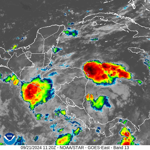
Looks like the GFS sobered up this morning and has it plowing into the Florida peninsula as a subtropical mess that looks like a cold front in December.
Then fantasyland opens up the week after.
This post was edited on 9/21/24 at 7:41 am
Posted on 9/21/24 at 8:34 am to Tarps99
quote:
Looks like the GFS sobered up this morning and has it plowing into the Florida peninsula as a subtropical mess that looks like a cold front in December.
Wut
It has a landfall just north of Tampa as a strong Cat 2
Euro has a Cat 1 at PC/Mexico beach but it’s a huge storm taking up most of the gulf. Not a strong hurricane but the wind field will be widespread
Canadian has a Cat 1 same path as Francine but turns NW inland and sweeps over Funroe into Arkansas
This post was edited on 9/21/24 at 10:12 am

Posted on 9/21/24 at 8:53 am to deltaland
Looks like a sloppy cat2 into big bend which wouldnt be a terrible outcome
Sparsely populated.
Sparsely populated.
Posted on 9/21/24 at 9:15 am to deltaland
quote:
Wut It has a landfall just north of Tampa as a strong Cat 2
Whether it is a Strong Cat 2 or something else, the moisture gets caught up in the trough making look like front, and the southwest side of the system is pretty dry like Francine.
I found Francine to be pretty interesting when I looked outside in Houma and there was no rain but the winds were howling like a mother.
This post was edited on 9/21/24 at 9:16 am

Posted on 9/21/24 at 9:37 am to ragincajun03
I’ve never seen the NWS go into this much detail before:
quote:
LONG TERM... (Sunday night through Friday) Issued at 256 AM CDT Sat Sep 21 2024 The interest continues to be in the extended in the tropical category so lets dive into that. We need to start off with the main large scale systems at play today then move into the extended to see how this all plays out. The stacked high near us will actually move east with time across the gulf coast into the western Atlantic by late Wed. This will allow the next trough to create a weakness down the Miss River Valley during that same time frame which splits the stacked high to the east and the new stacked high over the SW CONUS. Now we need to back up to the present again. The current east coast upper trough extends SSW down the east coast through the FL Keys then SW into the Yucatan then turns west as it exits Chiapas, MX into the EASTPAC. This is very important as this trough has a strong mid level reflection whose axis extends along this same arc. The east coast upper trough will keep moving east stretching the southern end and eventually cutting off an upper low from its southern most portion. It is this trough that will slowly cause the EASTPAC energy to begin flowing along its mid level boundary. And as we all know how mass moves along these boundaries in the northern hemisphere, it will eventually cause the disturbances flowing westeard along the ITCZ to stall in the eastern most portion of the Pacific which should occur by late today/evening. We will then see the activity along the ITCZ actually begin to flow eastward by Sunday. Where this trough axis bends over southern Mexico, it will cause a lot of this energy to be trasported NEward into the Caribbean during this time as well. We already see this flow occurring in the upper levels with help from IR sat imagery. Eventually, even the disturbances south of Mexico will turn northward by late Tue into Wed as the upper low begins to move NNW over the gulf. This flow of disturbances and deep moisture that has trasported into the Caribbean will then be allowed to start developing under a more hospitable environment. This "area" could be over the western Caribbean or southern gulf or both since this energy transport will also start moving into the southern gulf too which is the reason for the large area of 60% development probs. By now, one can now start putting the pieces together. During this same time frame(Wednesdayish), is when something is trying to get going near the Yucatan while, if you read the start of this paragraph, this is the same time that the weakness is located over the Miss River Valley. Any mass to the south of this CONUS trough will obviously be transported northward. It is in this time frame that things become very questionable, mainly because we are quite a ways out in time and all kinds of things that are not accounted for in the models could cause things to diverge from what they are trying to advertise. But a strong short wave is shown to begin moving south out of central Canada Mon/Tue digging into the base of this upper trough by Wed which would slow the trough while it does so. This is what we see bringing this system into the central and northern gulf with time via each model. Now...let alone the plethera of things not accounted for, timing will be the biggest question with this short wave into the base of the Miss River upper trough by mid week. This timing will be paramount as we move from Wed into the end of next week. It takes a while for all these things to come together with these types of scenarios but it looks likely that it will. One thing that all global models agree on is the transformation of this system from a barotropic to more baroclinicity as it moves north developing a frontal arc to its south as it moves toward the northern gulf coast, wherever that may be. This does not mean much except that when systems do this, typically their wind field begins to expand outward. This is very normal as we move into the end of September into October.
Posted on 9/21/24 at 9:51 am to loogaroo
Timing is still all over the place, and it matters a lot.
Also, the Icon is wild on this run. It spins up back-to-back Pacific hurricanes out of the gyre just off the coast of Southern Mexico. They make landfall within a couple days and ~300 miles of each other.
Also, the Icon is wild on this run. It spins up back-to-back Pacific hurricanes out of the gyre just off the coast of Southern Mexico. They make landfall within a couple days and ~300 miles of each other.
This post was edited on 9/21/24 at 9:53 am

Posted on 9/21/24 at 10:04 am to loogaroo
Cliffs?
Posted on 9/21/24 at 10:18 am to Y.A. Tittle
quote:
Cliffs?
Pretty much what has been discussed so far in this thread. It lays out the factors influencing initial development of storms in the gyre, goes into what will be the impetus of those storms (wherever they may consolidate) being pulled north, then discusses the steering mechanisms over the CONUS that may be at play to bring it towards landfall.
This post was edited on 9/21/24 at 10:19 am
Posted on 9/21/24 at 10:25 am to Y.A. Tittle
quote:
Cliffs?
Something may happen or it may not. They are monitoring for future development and potential impacts.
This post was edited on 9/21/24 at 10:26 am
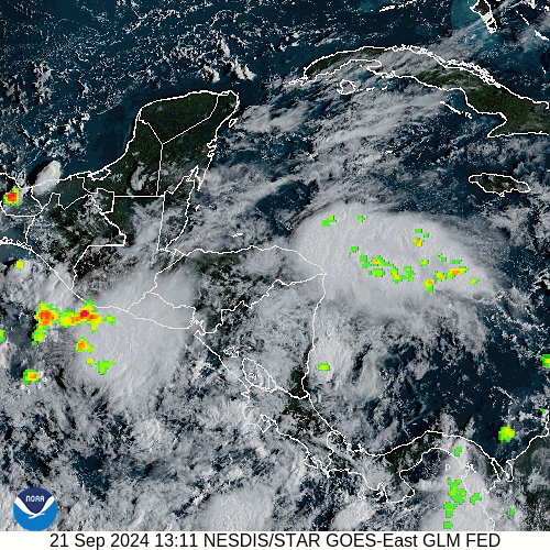
Posted on 9/21/24 at 10:27 am to BigBinBR
Pretty good development overnight and into this morning.

Posted on 9/21/24 at 10:30 am to BigBinBR
It's sounding like Navarre Beach is not going to be a good place to be middle of next week.
Someone correct me if I'm wrong.
Someone correct me if I'm wrong.

Posted on 9/21/24 at 10:50 am to Tiger Ike
quote:
It's sounding like Navarre Beach is not going to be a good place to be middle of next week.
Someone correct me if I'm wrong.
I wouldn't say that. Maybe it does hit close to there but this thing hasn't even formed yet. They can barely predict one 12 hours out from landfall so to think they would be right now is crazy.
This post was edited on 9/21/24 at 11:04 am

Posted on 9/21/24 at 10:54 am to LegendInMyMind
I like this site for visible radar.
Posted on 9/21/24 at 10:58 am to Ponchy Tiger
quote:
I wouldn't say that. Maybe it does hit close to there but this thing hasn't even formed yet.
I optimistically agree with you, just seems to be a lot of panhandle talk on here this morning.
Posted on 9/21/24 at 11:11 am to loogaroo
quote:
This is very normal as we move into the end of September into October.
This reminds me of the stories of the 1893 Chenier Caminada storm that killed 2,000 people near Grand Isle. A Cold front swept in the night before and you had a nice cool breeze out of the north and then wham a category 4 storm came barreling ashore. I think the anniversary is on October 1st.
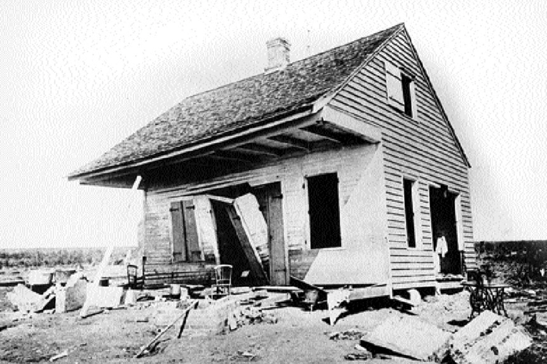
Fun fact the house in this photo was fixed up and moved to Cut Off after the storm, the house was moved and rebuilt again after getting damaged again for Hurricane Ida in 2021.
Curole House - Heart of Louisiana
This post was edited on 9/21/24 at 11:13 am
Posted on 9/21/24 at 11:39 am to Tarps99
Cold front gonna smash this thing.

 Page 28 of 310

Popular
Back to top