- My Forums
- Tiger Rant
- LSU Recruiting
- SEC Rant
- Saints Talk
- Pelicans Talk
- More Sports Board
- Fantasy Sports
- Golf Board
- Soccer Board
- O-T Lounge
- Tech Board
- Home/Garden Board
- Outdoor Board
- Health/Fitness Board
- Movie/TV Board
- Book Board
- Music Board
- Political Talk
- Money Talk
- Fark Board
- Gaming Board
- Travel Board
- Food/Drink Board
- Ticket Exchange
- TD Help Board
Customize My Forums- View All Forums
- Show Left Links
- Topic Sort Options
- Trending Topics
- Recent Topics
- Active Topics
Started By
Message
re: Helene - Recovery Begins...Devastating Flash Flooding in Western NC and Eastern TN
Posted on 9/25/24 at 10:30 am to bayoubengals88
Posted on 9/25/24 at 10:30 am to bayoubengals88
quote:
Fixed. ***NOT HELENE***
This system will be a topic for another thread once Helene clears out...
 2
2

Posted on 9/25/24 at 10:30 am to DVinBR
Helene track has moved about 50 miles west. This storm may end up hitting the same area that Hurricane Michael hit. Wow
Posted on 9/25/24 at 10:31 am to tgrgrd00
Perfect, makes sense. Thanks.

Posted on 9/25/24 at 10:31 am to Thracken13
quote:
did that fricker make a jog Left?
Still the consensus big bend landfall. The hurricane warning area has moved slightly west, now encompassing mexico beach, but the cone is tightening.
Mexico beach and Cedar key roughly represent the borders of the cone, so the area smack in the middle to cedar key should still be most worried here
Posted on 9/25/24 at 10:34 am to purple18
quote:
Helene track has moved about 50 miles west. This storm may end up hitting the same area that Hurricane Michael hit. Wow
Michael made landfall between Tyndall AFB and Mexico beach. Panacea is still squarely in the middle of the cone and that's 80 miles east of Michael landfall. This storm also looks like it's going to be a lot wider than Michael.
There was minimal damage west of the Hathaway bridge in Panama City during Michael while the Callaway area was wiped off the map. Callaway is about 20 miles from that bridge- and that's the reason everyone in Bay county is watching this thing with a tight arse hole. Landfall spot matters- but as of now we are still in the clear for direct hit
This post was edited on 9/25/24 at 10:38 am

Posted on 9/25/24 at 10:37 am to rds dc
Posted on 9/25/24 at 10:38 am to LegendInMyMind
yeah posting on my personal laptop and reading a work email on work laptop.
ill own it lol.
looks like we will get some good rain from it
ill own it lol.
looks like we will get some good rain from it
Posted on 9/25/24 at 10:40 am to Thracken13
Dog Island looks like it is going to get creamed. 
Posted on 9/25/24 at 10:40 am to rds dc
I want to believe Helene will be affected by shear from that cold front and limit strength
Posted on 9/25/24 at 10:42 am to Sal Minio
woof
Posted on 9/25/24 at 10:46 am to DVinBR
quote:
I want to believe Helene will be affected by shear from that cold front and limit strength
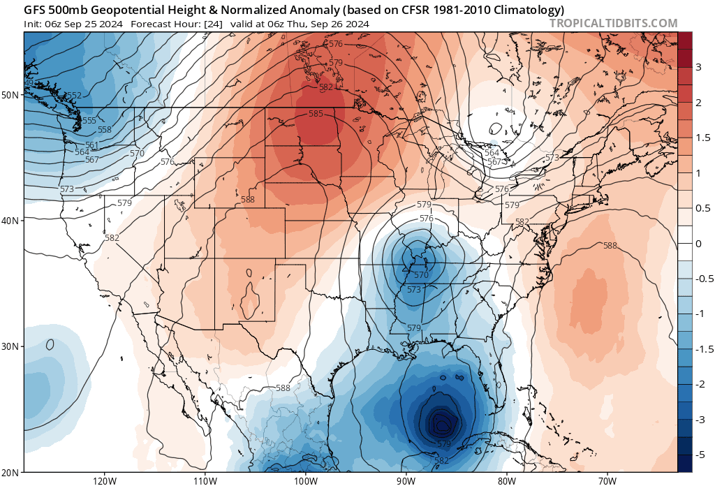
We'd be a lot better off in that regard if it were just the front. As it is, the front gets pinched off and forms a mid level low that will be in a really good position to actually help strengthen Helene.
ETA: It is also the interaction between the low and the storm after landfall that will be a threat for considerable flooding into western NC and surrounding areas.
This post was edited on 9/25/24 at 10:49 am
Posted on 9/25/24 at 10:48 am to DVinBR
quote:
I want to believe Helene will be affected by shear from that cold front and limit strength
The front washes out over Mississippi and Louisiana, resulting in a cutoff low. Helene accelerates towards land as it merges with the cutoff. That is why hurricane conditions will reach so far inland.
Posted on 9/25/24 at 10:52 am to bayoubengals88
They have been rapidly spinning something up behind Helene in the models so this isn't really surprising.

Posted on 9/25/24 at 10:52 am to rds dc
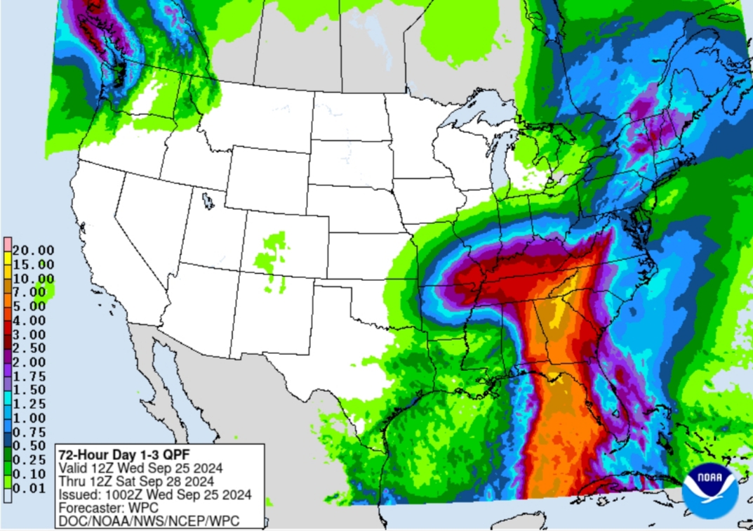
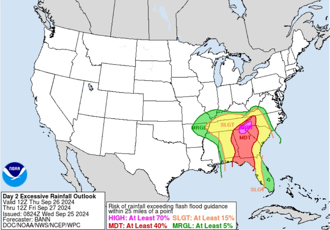
That's why I've posted that people in Georgia and Southern Tennessee need to pay attention as well. Lots of flooding will also come from this system, it's not just the wind damage. Those mountain areas are going to experience some serious flooding.
Posted on 9/25/24 at 10:53 am to rds dc
about as bad a situation as you can get
Posted on 9/25/24 at 10:54 am to friendlyobservation
One at a time!!
Posted on 9/25/24 at 10:55 am to Oates Mustache
quote:
Those mountain areas are going to experience some serious flooding.
Looking at the rainfall forecast in the OP, the heaviest rain will be in the mountainous area where TN, SC, & NC meet. I can't imagine what the flooding in that area will be like with it rushing off the mountains to the valley areas.
Posted on 9/25/24 at 10:55 am to Roll Tide Ravens
quote:
10 AM CDT Advisory
Wow just keep seeing slight west shifts. This may just go over right where Michael did

Posted on 9/25/24 at 10:55 am to tiger91
Heading to Pensacola and I see hundreds of power line trucks on the way for you Florida
Posted on 9/25/24 at 10:56 am to Oates Mustache
quote:
That's why I've posted that people in Georgia and Southern Tennessee need to pay attention as well. Lots of flooding will also come from this system, it's not just the wind damage. Those mountain areas are going to experience some serious flooding.
Yep. The flood threat for the NC/TN border area is considerable, and that's one of the worst places for flash flooding.

 Page 102 of 310

Popular
Back to top