- My Forums
- Tiger Rant
- LSU Recruiting
- SEC Rant
- Saints Talk
- Pelicans Talk
- More Sports Board
- Fantasy Sports
- Golf Board
- Soccer Board
- O-T Lounge
- Tech Board
- Home/Garden Board
- Outdoor Board
- Health/Fitness Board
- Movie/TV Board
- Book Board
- Music Board
- Political Talk
- Money Talk
- Fark Board
- Gaming Board
- Travel Board
- Food/Drink Board
- Ticket Exchange
- TD Help Board
Customize My Forums- View All Forums
- Show Left Links
- Topic Sort Options
- Trending Topics
- Recent Topics
- Active Topics
Started By
Message
re: Harvey ***Catastrophic Flooding Event***
Posted on 8/29/17 at 1:25 pm to slackster
Posted on 8/29/17 at 1:25 pm to slackster
quote:I'm watching radar. Lake Chuck may just be about to have major problems.
Yeah Lake Charles area doesn't need anymore rain, but it looks like they'll get it.
I'm beginning to wonder about the Beaumnont, Orange, Port Author area too.
 1
1


Posted on 8/29/17 at 1:26 pm to 4LSU2

Posted on 8/29/17 at 1:30 pm to GEAUXmedic
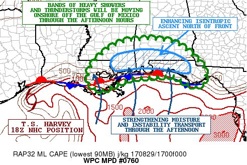
MESOSCALE PRECIPITATION DISCUSSION 0760
NWS WEATHER PREDICTION CENTER COLLEGE PARK MD
207 PM EDT TUE AUG 29 2017
AREAS AFFECTED...SOUTHEAST LA...SOUTHERN MS...SOUTHERN AL...FL
PANHANDLE
CONCERNING...HEAVY RAINFALL...FLASH FLOODING LIKELY
VALID 291805Z - 300005Z
SUMMARY...BANDS OF HEAVY SHOWERS AND THUNDERSTORMS WILL BE
ADVANCING NORTH THROUGH THE AFTERNOON IN OFF THE GULF OF MEXICO.
FLASH FLOODING IS LIKELY GIVEN THE EXTREMELY HEAVY RAINFALL RATES
THAT ARE EXPECTED.
DISCUSSION...RADAR IMAGERY IS SHOWING AN AXIS OF HEAVY RAINFALL
STRETCHING FROM SOUTHEAST LA AND AREAS OF SOUTHERN MS EASTWARD
ACROSS FAR SOUTHERN AL AND APPROACHING THE FL PANHANDLE. THE
CONVECTION IS DEVELOPING NEAR AND JUST NORTH OF A STATIONARY FRONT
DRAPED ACROSS A LARGE AREA OF THE GULF COAST. INCREASING SOUTH TO
SOUTHWEST FLOW ASSOCIATED WITH A DEEP LAYER WARM CONVEYOR BELT
WELL EAST OF THE CENTER OF T.S. HARVEY IS GREATLY ENHANCING THE
ISENTROPIC ASCENT ACROSS THE REGION. MEANWHILE...STRONGER SURFACE
CONVERGENCE/LOW LEVEL FORCING NEAR THE FRONT AND GREATER
MOISTURE/INSTABILITY TRANSPORT IS NOTED AS WELL.
CLOUD TOPS HAVE BEEN GENERALLY COOLING OVER THE LAST HOUR AS
LARGER SCALE FORCING INCREASES...AND THIS IS ESPECIALLY NOTED
ACROSS FAR SOUTHERN AL AND AREAS JUST OFFSHORE OF THE WESTERN FL
PANHANDLE WHERE VERY HEAVY RAINFALL IS ABOUT TO ARRIVE IN OFF THE
GULF OF MEXICO. PWATS ARE ALREADY HIGHLY REFLECTIVE OF A DEEP
TROPICAL AIRMASS WITH VALUES GENERALLY IN THE 2.25 TO 2.5 INCH AND
THIS WILL SUPPORT EXTREME RAINFALL RATES IN EXCESS OF 3 INCHES/HR
WITHIN THE STRONGER CONVECTIVE CORES.
THE LATEST HIRES MODEL CONSENSUS SUGGESTS SOME GRADUAL NORTHWARD
ADVANCE OF THE AFOREMENTIONED FRONTAL ZONE. THIS SHOULD HELP ALLOW
SOME OF THE STRONGER CONVECTIVE ELEMENTS AND RESULTING HEAVY
RAINFALL TO LIFT A BUT FARTHER NORTH THROUGH THE AFTERNOON HOURS
WHICH WILL ENCAPSULATE MORE AREAS OF ESPECIALLY SOUTHERN AL AND
THE FL PANHANDLE.
MEANWHILE...THERE ARE SOME SIGNALS THAT CONVECTIVE BANDING COULD
BECOME BETTER ORGANIZED/CONCENTRATED OVER AREAS OF FAR SOUTHEAST
LA AND SOUTHERN MS WHICH WOULD GRADUALLY MOVE BACK INTO FAR
SOUTHERN AL LATER THIS AFTERNOON OR EARLY THIS EVENING. RECENT
HRRR/HRRRX GUIDANCE ALONG WITH HRRR-TLE AND 12Z ARW DATA WERE
SUGGESTING THIS. OVERALL...EXPECT THROUGH 00Z ADDITIONAL RAINFALL
TOTALS OF GENERALLY 3 TO 6 INCHES...WITH ISOLATED HEAVIER TOTALS
THAT COULD APPROACH 8+ INCHES OVER FAR SOUTHERN MS AND FAR
SOUTHERN AL AS SUGGESTED BY THE 15Z HRRR-TLE. FLASH FLOODING IS
LIKELY ACROSS THESE AREAS GIVEN THE OVERALL SET-UP AND CONCERN FOR
SUCH INTENSE SHORT-TERM RAINFALL RATES.
Posted on 8/29/17 at 1:30 pm to ihometiger
Several pages ago, someone asked about what the down stream look of Buffalo Bayou is.
The facebook link shows that amount of water covering Rt 6 as the Corps of Engineers Colonel standing on top of Barker Dam talks about the situation.
[link=https://www.facebook.com/GalvestonDistrict/videos/10156538119378032/?permPage=1[/link]
The facebook link shows that amount of water covering Rt 6 as the Corps of Engineers Colonel standing on top of Barker Dam talks about the situation.
[link=https://www.facebook.com/GalvestonDistrict/videos/10156538119378032/?permPage=1[/link]

Posted on 8/29/17 at 1:33 pm to BeYou
BeYou, that sucks, but if there is any silver lining, that damage will not be considered flood damage, and will be covered under the Homeowner's policy. It's WAYYYYYYY better to deal with them on the damages than with the federal flood adjusters. Claim should be processed much more efficiently and payment coming from your own insurer. I know that doesn't help much.
Posted on 8/29/17 at 1:33 pm to Redbone
quote:
I'm beginning to wonder about the Beaumnont, Orange, Port Author area too.
I work with some people out of that area. None of them have water in their houses yet but are pretty much flooded in.
Lots of roads are flooded and/or blocked off.
Posted on 8/29/17 at 1:33 pm to real turf fan
Is the US Army Corps of Engineers really the most qualified for flood control?
I know all these recent events have been thousand year storms but is there not another entity that could take over flood control? private entities?
I know all these recent events have been thousand year storms but is there not another entity that could take over flood control? private entities?
Posted on 8/29/17 at 1:34 pm to Festus
Definitely sounds like a silver lining. I, however, have not had to deal with Homeowner's. With as many claims that they will be taking, does that impact their performance and payout times?
Posted on 8/29/17 at 1:34 pm to castorinho
The new GFS prediction, basically Houston will start drying out in 48 hours, but only for 3 days, before a new system coming off the Yucatan moves in. It is showing light to heavy rain for 3 to 4 days over the Houston and SE TX coast into LA. GFS is not predicting anything major but, they didn't either with Harvey.
This is 180 hours from now by the model (this is NOT Harvey):

This is 180 hours from now by the model (this is NOT Harvey):
Posted on 8/29/17 at 1:35 pm to slackster
No bueno for Vinton.
Posted on 8/29/17 at 1:36 pm to ForkEmDemons
My family is in Beaumont and Orange. All are flooded in but none have water in their house. My brother has water in his game room but it is a converted garage and the actual house is a good foot and a half higher. It should go down quickly once they have a break.
Posted on 8/29/17 at 1:36 pm to ihometiger
Still looking decent for this area.
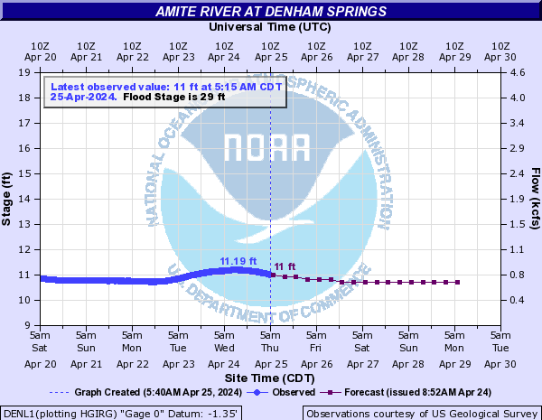
Posted on 8/29/17 at 1:37 pm to Monday
Yup. Denham is fine.

Posted on 8/29/17 at 1:38 pm to ihometiger
Super
Posted on 8/29/17 at 1:38 pm to ihometiger
The Euro run also showed a low pressure popping in the Bay of Campeche. Never amounted to much in the way of a named storm but it would bring more rain. I hate to speak in absolutes but surely it wouldn't amount to anywhere near the kind of rainfall they have already had. But even a heavy downpour at that point could cause quick flooding.
Posted on 8/29/17 at 1:39 pm to BigB0882
Euro coming in stronger for the potential system next week. Still not that strong but it's got a 1004mb low in the central Gulf.
This post was edited on 8/29/17 at 1:41 pm

Posted on 8/29/17 at 1:40 pm to ihometiger
quote:The Euro is currently running and picking up on this too
The new GFS prediction, basically Houston will start drying out in 48 hours, but only for 3 days, before a new system coming off the Yucatan moves in. It is showing light to heavy rain for 3 to 4 days over the Houston and SE TX coast into LA. GFS is not predicting anything major but, they didn't either with Harvey.

Posted on 8/29/17 at 1:40 pm to ihometiger
That fricker out in the Pacific is going to cross over Mexico and dump more rain on TX, isn't it?

Posted on 8/29/17 at 1:41 pm to GEAUXmedic
that recon pass found a 50 kt sfmr wind.
Posted on 8/29/17 at 1:41 pm to BigB0882
quote:
The Euro run also showed a low pressure popping in the Bay of Campeche. Never amounted to much in the way of a named storm but it would bring more rain. I hate to speak in absolutes but surely it wouldn't amount to anywhere near the kind of rainfall they have already had. But even a heavy downpour at that point could cause quick flooding.
someone shoot peej before he types anything.

 Page 561 of 618

Popular
Back to top