




- My Forums
- Tiger Rant
- LSU Recruiting
- SEC Rant
- Saints Talk
- Pelicans Talk
- More Sports Board
- Fantasy Sports
- Golf Board
- Soccer Board
- O-T Lounge
- Tech Board
- Home/Garden Board
- Outdoor Board
- Health/Fitness Board
- Movie/TV Board
- Book Board
- Music Board
- Political Talk
- Money Talk
- Fark Board
- Gaming Board
- Travel Board
- Food/Drink Board
- Ticket Exchange
- TD Help Board
Customize My Forums- View All Forums
- Show Left Links
- Topic Sort Options
- Trending Topics
- Recent Topics
- Active Topics
Started By
Message
re: Frontal Low Nestor - Nearing Landfall in the Panhandle - The End of Hurricane Season?
Posted on 10/17/19 at 11:06 am to biggsc


Posted on 10/17/19 at 11:06 am to biggsc

All storm preparations should come to conclusion as soon as possible as conditions will start to deteriorate across the warned area. Once winds reach tropical storm force emergency vehicles will not be able to go out and render help if needed.
This post was edited on 10/17/19 at 11:13 am
 1
1

Posted on 10/17/19 at 11:08 am to LaBR4


Posted on 10/17/19 at 12:12 pm to rds dc
I have just one question...
Has Florida postponed the 2020 game against LSU yet?
Has Florida postponed the 2020 game against LSU yet?
Posted on 10/17/19 at 12:36 pm to Cowboyfan89
No but wondering if they make that trip to South Carolina now
Posted on 10/17/19 at 1:10 pm to Cowboyfan89
They probably want a rematch of LSU from last week since they clearly were distracted and had to prep for this storm.
Posted on 10/17/19 at 4:11 pm to deuce985
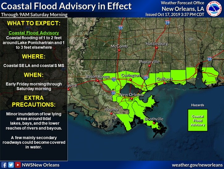
Anyone know what kind of surge Fourchon may get? Buddy has a camper by Morans.

Posted on 10/17/19 at 5:21 pm to Bedhog
quote:
Anyone know what kind of surge Fourchon may get? Buddy has a camper by Morans
I wouldn’t keep anything movable outside the Hurricane protection system, so your buddy could be a moron if he left it at Morans.
Seriously though, they are expecting higher than normal tides. At 1-2 feet he should be okay as the marina is built up to about the road level.
Anything higher, he could have some problems. Especially, just trying to to get in and out of there. The road just below the floodgate in Golden Meadow typically floods before Fourchon because it is lower. That is why they need to finish the bridge.
In hindsight, maybe they should have built the section between Golden Meadow and Leeville first.
The system may stay far enough to the south and east of the area and it may not be an issue. So far no one is calling for an evacuation yet.
This post was edited on 10/17/19 at 6:37 pm
Posted on 10/17/19 at 6:07 pm to rds dc
This burns my arse up. Pensacola area. 
Posted on 10/17/19 at 6:18 pm to Tarps99
quote:
so your buddy would be a moron if he left it at Morans.
To be fair Moran is a moron


Posted on 10/17/19 at 7:19 pm to tgrbaitn08
This is a very interesting storm.

Posted on 10/17/19 at 7:20 pm to tgrbaitn08
quote:
Moran is a moron
That guy...

Posted on 10/17/19 at 8:20 pm to rds dc
Per normal, the weather channel was awfulizing at noon today.
As long as it's no worse here than the actual forecast, I would welcome it - my irrigation water bill needs it.
"Minor" catch is present forecast puts central FL in the NE quadrant.
As long as it's no worse here than the actual forecast, I would welcome it - my irrigation water bill needs it.
"Minor" catch is present forecast puts central FL in the NE quadrant.
This post was edited on 10/17/19 at 8:27 pm
Posted on 10/17/19 at 10:02 pm to Tarps99
My question is they are calling for 20-25 mph NE winds in Fourchon area Friday night. Will the surge we able to get that high with that hard of a wind ripping?

Posted on 10/17/19 at 10:08 pm to Tarps99
Meh. We left ours at Moran’s for Barry, it had higher surge than predicted here and water never even got over the bulkhead. Just plot out where my October beach rental is, it’s a more accurate prediction of landfall than a Cantore visit. 3 straight years now.
Posted on 10/17/19 at 10:09 pm to tgrbaitn08
GFY dude. Did he frick your woman? He’s a great guy.
Posted on 10/18/19 at 9:59 am to rds dc
60 mph winds and 1001 mb pressure but still not a well-defined center...Stay safe Floridians...
quote:
The satellite presentation of the system features an area of very
deep convection with cloud tops colder than -80C within the eastern
part of a rather broad and elongated surface circulation seen in
visible satellite imagery and data from an Air Force Reserve
Hurricane Hunter aircraft. A NOAA Hurricane Hunter aircraft found
flight-level winds as high as 72 kt and SFMR winds of 45-50 kt
southeast of the ill-defined center, and based on these data the
initial intensity is set to 50 kt. The NOAA aircraft also measured a
pressure of around 1001 mb. While the cyclone has deepened, the
circulation is still quite elongated and not well defined, so the
system is maintained as a Potential Tropical Cyclone for now.
This post was edited on 10/18/19 at 9:59 am

Posted on 10/18/19 at 10:07 am to NorthEndZone
It's as much a midlat cyclone as a tropical one. Got a front on the east side and getting some spin help from the upper low moving out of Texas.
That being said, the convection near the center is stout. Going to bring a healthy surge into the eastern panhandle.
That being said, the convection near the center is stout. Going to bring a healthy surge into the eastern panhandle.
Posted on 10/18/19 at 10:27 am to Duke
quote:
It's as much a midlat cyclone as a tropical one. Got a front on the east side and getting some spin help from the upper low moving out of Texas. That being said, the convection near the center is stout. Going to bring a healthy surge into the eastern panhandle.
Indubitably, Good Sir.
Posted on 10/18/19 at 11:55 am to OmniPundit
At New Orleans international KMSY, the highest wind gust this Friday morning has been 19 knots (22 mph) from the ENE (060 degrees).
Lowest pressure has been 1010.6 mb (29.84 inches). PCPN since midnight : trace
Lowest pressure has been 1010.6 mb (29.84 inches). PCPN since midnight : trace

 Page 4 of 5

Popular
Back to top
 Follow TigerDroppings for LSU Football News