- My Forums
- Tiger Rant
- LSU Recruiting
- SEC Rant
- Saints Talk
- Pelicans Talk
- More Sports Board
- Fantasy Sports
- Golf Board
- Soccer Board
- O-T Lounge
- Tech Board
- Home/Garden Board
- Outdoor Board
- Health/Fitness Board
- Movie/TV Board
- Book Board
- Music Board
- Political Talk
- Money Talk
- Fark Board
- Gaming Board
- Travel Board
- Food/Drink Board
- Ticket Exchange
- TD Help Board
Customize My Forums- View All Forums
- Show Left Links
- Topic Sort Options
- Trending Topics
- Recent Topics
- Active Topics
Started By
Message
re: Francine - Landfall in Terrebonne Parish as CAT 2 100 mph
Posted on 9/11/24 at 1:58 pm to The Boat
Posted on 9/11/24 at 1:58 pm to The Boat
quote:
We'll see if NHC has the stones to drop it from 90 mph leading up to landfall.
It seems that true land wind speed is always around 10mph less than what is projected. The hurricane hunters measure the fastest possible wind speed in the heart of the storm over water. Land is whiskey dick for a storm.
 0
0


Posted on 9/11/24 at 1:58 pm to TH03
I always thought it was when the eyewall first touches land. In fact, I can recall weather people on TV excitedly calling the landfall when this happened.

Posted on 9/11/24 at 1:59 pm to LSUFanHouston
You ain’t getting the eye
Posted on 9/11/24 at 1:59 pm to Zombie Bob
quote:
First time caller, long time listener. Is this the longest thread in TD history? Thanks, I’ll hang up and listen
Oh. I get it.

Posted on 9/11/24 at 1:59 pm to Hulkklogan
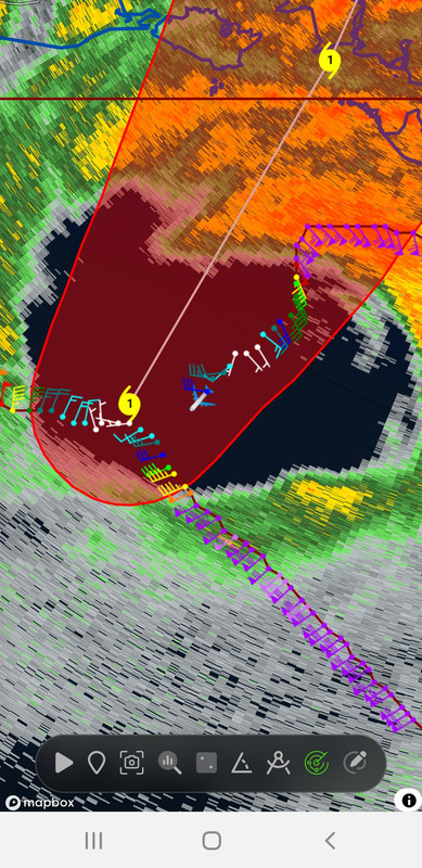
Looks like the eastern eye wall has become the strongest part of the eye while the formerly strong western eye wall has weakened considerably.

This post was edited on 9/11/24 at 2:06 pm
Posted on 9/11/24 at 1:59 pm to geauxpurple
How did they know where the eyewall boundary is located?
Posted on 9/11/24 at 1:59 pm to The Boat
quote:
Recon data site since tropicaltiddles isn't updating
Tropicaltiddles would be a way better website than Tropical Tidbits.

Posted on 9/11/24 at 2:00 pm to slackster
SUMMARY OF 200 PM CDT...1900 UTC...INFORMATION
-----------------------------------------------
LOCATION...28.7N 91.8W
ABOUT 80 MI...125 KM SSW OF MORGAN CITY LOUISIANA
ABOUT 135 MI...220 KM SW OF NEW ORLEANS LOUISIANA
MAXIMUM SUSTAINED WINDS...90 MPH...150 KM/H
PRESENT MOVEMENT...NE OR 40 DEGREES AT 17 MPH...27 KM/H
MINIMUM CENTRAL PRESSURE...976 MB...28.82 INCHES
Posted on 9/11/24 at 2:00 pm to geauxpurple
They could fly around in that eye for a while if they really wanted to. 
ETA: First post on page 350.
ETA: First post on page 350.
This post was edited on 9/11/24 at 2:01 pm

Posted on 9/11/24 at 2:01 pm to gaetti15
Very steady, sustained rainfall in Harvey, now.
Posted on 9/11/24 at 2:02 pm to LegendInMyMind
I was going to make a comment about that on the last page when so and so told LSUHouston that St.Bernard wouldn't get the eye ha.
If the eye wants to keep being all oblongated then maybe Arabi will
If the eye wants to keep being all oblongated then maybe Arabi will
Posted on 9/11/24 at 2:02 pm to LegendInMyMind
Three
Fiddy
IN
Fiddy
IN

Posted on 9/11/24 at 2:02 pm to gaetti15
This guy on the weather channel is an idiot

Posted on 9/11/24 at 2:02 pm to Tarpon08
In on tree fiddy
Posted on 9/11/24 at 2:03 pm to RedPop4
Honestly watching TWC and various other stuff, looks like by the time it makes it to Baton Rouge it will have shifted east and we may not get much of anything
I’ve been wrong multiple times before though
I’ve been wrong multiple times before though
Posted on 9/11/24 at 2:03 pm to LegendInMyMind
quote:
What page are we on?

Posted on 9/11/24 at 2:03 pm to Nguyener
Not intended.
Point being we are just 6 hours out and still had massive fear porn from Fox.
And yes, it could still rain for only an hour and flood areas of the city just like it does almost every month.
God speed to all. May it be a minor hurricane with limited damage.
Point being we are just 6 hours out and still had massive fear porn from Fox.
And yes, it could still rain for only an hour and flood areas of the city just like it does almost every month.
God speed to all. May it be a minor hurricane with limited damage.
This post was edited on 9/11/24 at 2:05 pm
Posted on 9/11/24 at 2:04 pm to GeauxldMember
TREE FITTY
Posted on 9/11/24 at 2:04 pm to The Boat
quote:
Looks like the eastern eye wall has become the strongest part of the eye while the formerly strong western eye wall and weakened considerably.

 Page 349 of 492

Popular
Back to top