- My Forums
- Tiger Rant
- LSU Recruiting
- SEC Rant
- Saints Talk
- Pelicans Talk
- More Sports Board
- Fantasy Sports
- Golf Board
- Soccer Board
- O-T Lounge
- Tech Board
- Home/Garden Board
- Outdoor Board
- Health/Fitness Board
- Movie/TV Board
- Book Board
- Music Board
- Political Talk
- Money Talk
- Fark Board
- Gaming Board
- Travel Board
- Food/Drink Board
- Ticket Exchange
- TD Help Board
Customize My Forums- View All Forums
- Show Left Links
- Topic Sort Options
- Trending Topics
- Recent Topics
- Active Topics
Started By
Message
 1
1

Posted on 9/7/24 at 3:15 pm to rds dc
looks like models are showing a fairly comma shaped northeastwardly sheared system, which displaces most of the storm off to the northeast
the center of the storm may go in somewhere, but the worst of the storm may not be where the center goes in
the center of the storm may go in somewhere, but the worst of the storm may not be where the center goes in
Posted on 9/7/24 at 3:30 pm to DVinBR
Depends if the system can reach hurricane status and tighten up its gradient it could fight off the dry air better. If it’s a weak unorganized TS then the scenario you mentioned that would definitely be in play.
Posted on 9/7/24 at 3:32 pm to SWLA92
When would this thing be hitting land if it ends up hitting from say Houston to New Orleans.
Posted on 9/7/24 at 3:39 pm to diat150
I think the consensus is Wednesday but could change
Posted on 9/7/24 at 3:45 pm to rds dc
So we can blame the cool front for this damn storm
Posted on 9/7/24 at 4:03 pm to nicholastiger
In New Orleans and I feel lied to about a cool front this weekend.

Posted on 9/7/24 at 4:20 pm to TigrrrDad
quote:College Station
So am I better off catching snakes in West Texas or the Everglades next weekend?
Posted on 9/7/24 at 4:24 pm to ned nederlander
quote:
In New Orleans and I feel lied to about a cool front this weekend.
Might have to wait until next weekend once the other system gets out of the way.
I see a 69 next Saturday morning.
Posted on 9/7/24 at 4:38 pm to Tarps99
Is it me or does 90L still look pretty healthy on the satellite view besides all the rain blowing to the east of the center?
Posted on 9/7/24 at 4:40 pm to Rick9Plus
This is the biggest bullshite cold front ever.
Posted on 9/7/24 at 4:42 pm to Bayou_Tiger_225
New Icon still into Vermilion coastline then over Laffy
Posted on 9/7/24 at 4:43 pm to Tarps99
quote:Voyeur much brah?
I see a 69 next Saturday morning.
Posted on 9/7/24 at 5:07 pm to BananaManCan
quote:
This is the biggest bullshite cold front ever.
Speak for yourself. I have 51°, 54°, and 58° for lows the next three nights. It might hit 80° for the high tomorrow. It hadn't made it here last night and we only got down to 67° at the house.
This post was edited on 9/7/24 at 5:08 pm

Posted on 9/7/24 at 5:11 pm to stout
This post was edited on 9/7/24 at 5:12 pm
Posted on 9/7/24 at 5:19 pm to NorthEndZone
For 91L, the heaviest rain will be along and west of the track since the system will be interacting with a shortwave trough coming out of Texas.
18z GFS

18z GFS

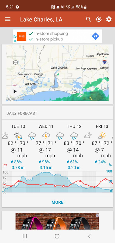
Posted on 9/7/24 at 5:21 pm to rds dc
Posted on 9/7/24 at 5:22 pm to rds dc
Some big totals just offshore
Posted on 9/7/24 at 5:54 pm to lsuman25
They can stay offshore too.
Posted on 9/7/24 at 6:04 pm to NervousNellie


 Page 28 of 492

Popular
Back to top