- My Forums
- Tiger Rant
- LSU Recruiting
- SEC Rant
- Saints Talk
- Pelicans Talk
- More Sports Board
- Fantasy Sports
- Golf Board
- Soccer Board
- O-T Lounge
- Tech Board
- Home/Garden Board
- Outdoor Board
- Health/Fitness Board
- Movie/TV Board
- Book Board
- Music Board
- Political Talk
- Money Talk
- Fark Board
- Gaming Board
- Travel Board
- Food/Drink Board
- Ticket Exchange
- TD Help Board
Customize My Forums- View All Forums
- Show Left Links
- Topic Sort Options
- Trending Topics
- Recent Topics
- Active Topics
Started By
Message

 5
5

Posted on 9/10/24 at 1:51 pm to Chicken
That’s what I been wondering
It looks like a separate system but it’s got to be working with the other one somehow
It looks like a separate system but it’s got to be working with the other one somehow
Posted on 9/10/24 at 1:51 pm to bayoubengals88
This storm must be more powerful than we think. Just lost power. I live near Baton Rouge.
Posted on 9/10/24 at 1:51 pm to Chicken
quote:
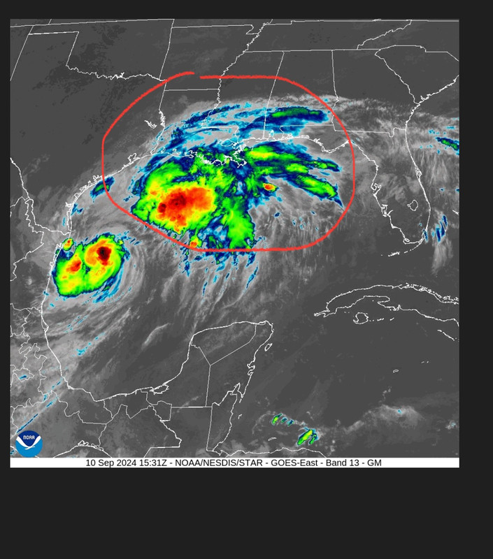
Is this blob considered part of the hurricane or a separate storm:
It started as part of the storm and presumably still is.
For most of the last 24 hours it has looked more potent than the actual center of the storm.

Posted on 9/10/24 at 1:52 pm to Chicken
quote:
this blob considered part of the hurricane or a separate storm:
The scientific term for it is an arse pile of storms.

Posted on 9/10/24 at 1:52 pm to SlidellCajun
Where is current track landfall? Its changed so much over the past few days.
Still around Franklin?
Still around Franklin?
Posted on 9/10/24 at 1:53 pm to Chicken
chicken, its a huge beta fish, not a storm system. look at it again.

Posted on 9/10/24 at 1:53 pm to alphaandomega
between vermillion and terrebonne bays

Posted on 9/10/24 at 1:53 pm to slackster
Thought that blob is just part of the stalled out front from the weekend

Posted on 9/10/24 at 1:54 pm to Chicken
Interesting looking radar. It looks like we’ll get a solid storm system from that stalled front that will keep everything wet and rainy and then a small break and then the actual outer bands of the hurricane will move in land. I don’t like that. All that water the last week and then this storm is prime conditions for trees uprooting.
This post was edited on 9/10/24 at 1:57 pm
Posted on 9/10/24 at 1:55 pm to yaboidarrell
quote:
What's the wind forecast look like for Nola?
same
Posted on 9/10/24 at 1:56 pm to Cosmo
quote:
Thought that blob is just part of the stalled out front from the weekend
Thats what Bob Breck said it was. He said that blob was was helping limit the strengthening and causing a weakness that was leading to more eastern shifts. Bob's call was NOLA direct hit or east of NOLA.

Posted on 9/10/24 at 1:56 pm to Nguyener
What are y’all looking at? This is clearly a band from Francine
Posted on 9/10/24 at 1:56 pm to Cosmo
quote:
Thought that blob is just part of the stalled out front from the weekend
They’re all related. Most of that “blob” spun out of Francine starting about 7-8pm yesterday.
Posted on 9/10/24 at 1:57 pm to yaboidarrell
quote:
What's the wind forecast look like for Nola?


Posted on 9/10/24 at 1:58 pm to tigersownall
quote:
What are y’all looking at? This is clearly a band from Francine
It’s been moving opposite of Francine’s circulation all day.

Posted on 9/10/24 at 1:58 pm to Festus
quote:
When describing who to trust on here yesterday, someone left off tBoat. I was going to jump in and defend him. Then I realized I would come across as a white knight fig so I simply observed and kept my mouth shut. I kinda regret it now. I hope he understands.
I spoke up for Slackster and immediately felt the gay.
I think he downvoted me too.
Posted on 9/10/24 at 2:01 pm to TDsngumbo
quote:
He was asking for the flood guru, not the roux guru.
Both are essential in times like this

Posted on 9/10/24 at 2:02 pm to Havoc
Man, I never watch the weather channel, but I forget the fear porn the weather channel is when it comes to anything, much less a hurricane.
Posted on 9/10/24 at 2:03 pm to CollegeFBRules
gotta grow that year over year viewership and revenue somehow

 Page 234 of 492

Popular
Back to top