- My Forums
- Tiger Rant
- LSU Recruiting
- SEC Rant
- Saints Talk
- Pelicans Talk
- More Sports Board
- Fantasy Sports
- Golf Board
- Soccer Board
- O-T Lounge
- Tech Board
- Home/Garden Board
- Outdoor Board
- Health/Fitness Board
- Movie/TV Board
- Book Board
- Music Board
- Political Talk
- Money Talk
- Fark Board
- Gaming Board
- Travel Board
- Food/Drink Board
- Ticket Exchange
- TD Help Board
Customize My Forums- View All Forums
- Show Left Links
- Topic Sort Options
- Trending Topics
- Recent Topics
- Active Topics
Started By
Message
re: Flood threat on northern Gulf coast
Posted on 8/10/16 at 4:37 pm to GEAUXmedic
Posted on 8/10/16 at 4:37 pm to GEAUXmedic
quote:
Margaret Orr WDSU
 0
0

Posted on 8/10/16 at 4:40 pm to LSUsmartass
quote:I'm curious what the European model is currently
What models are saying lots of rain north of the lake?
showing.
Posted on 8/10/16 at 4:45 pm to bobbyleewilliams
quote:
quote:
What models are saying lots of rain north of the lake?
I'm curious what the European model is currently
showing.
Here is the latest thinking from the NWS:
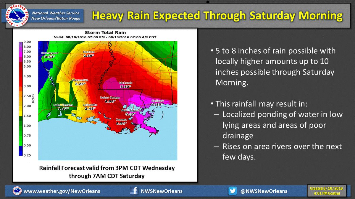
That is pretty much in line with what the models are showing spatially but a bit more conservative on the totals side. That is usually a good forecast technique, esp. with hard to model systems with lots of convection.
Posted on 8/10/16 at 4:47 pm to LSUsmartass
quote:
What models are saying lots of rain north of the lake?
The heck if I know. Heard that on the radio, and saw an NWS graphic, which was just posted in this thread. But even that had much lower storm totals.
Posted on 8/10/16 at 4:51 pm to rds dc
quote:Thanks for the info, you always come
rds dc
through.
Posted on 8/10/16 at 7:42 pm to rds dc
Has the bad stuff passed?
Posted on 8/11/16 at 6:02 am to LSUsmartass
quote:
Has the bad stuff passed?
Posted on 8/11/16 at 6:15 am to bobbyleewilliams
For baton rouge? No

Posted on 8/11/16 at 6:26 am to LSUsmartass
It's coming in waves. Yesterday was just a primer for today's event. Last night they extended the flood watch west and north to cover BTR. Yesterday's rains saturated the grounds through the coastal parishes, so they upgraded to a flash flood watch. Yesterday I got 3.2". Some areas offshore got 20+. Storms are already firing off this morning over Terrebonne and offshore. CAPE (energy) is already high and with no cap in place the chance of storms is greater. These storms will tap into the abundant moisture (yesterday's sounding had precip water values of 2.78" which according to NWS is higher than most tropical systems we have had). The storms will expand inland throughout the day with precip rates of 1-2" per hour, look for much of the same Friday, although more widespread. This morning's QPF shows 5-7" over the entire area with isolated areas of up to 10". They can't predict the exact locations of higher amounts, so I'd just say 5-7" across the area, with some locations getting up to 10, and some getting 2-5". It just depends where these storms set up and where they train, like yesterday where I got 3", compared to one of my friends 20 miles away who got 0.2" of rain.
This post was edited on 8/11/16 at 6:28 am

Posted on 8/11/16 at 6:57 am to GEAUXmedic
I just don't see the Baton Rouge area getting as much rain as predicted. Some strong showers but just not as bad. The New Orleans area will get a ton though.

Posted on 8/11/16 at 7:21 am to dukke v
That's what everyone was saying a few months ago when we got 20" @ my house in 2 days
Posted on 8/11/16 at 8:05 am to GEAUXmedic
So are we talking widespread road and school closures again?
Posted on 8/11/16 at 8:14 am to GEAUXmedic
quote:
Some areas offshore got 20+.
the gulf is flooded
Posted on 8/11/16 at 8:40 am to dukke v
quote:
dukke v
You seem to know your shite...can you break down your reasoning?
Posted on 8/11/16 at 8:43 am to Spilled Milk
quote:
dukke v
You seem to know your shite..
You must be new her.
Posted on 8/11/16 at 8:49 am to notiger1997
It has been raining steady in Houma since lunch time yesterday.
Posted on 8/11/16 at 8:51 am to bayoudude
decided not to go to theriot this w/e
Posted on 8/11/16 at 8:54 am to Spilled Milk
The majority of the system is staying in the gulf. It's moving almost straight west at a very slow pace. If it starts to move north very much then BR could be in for some big time rain. I see all these models and such, just seems that the southern part of the state will feel the brunt of it more than the BR area.

Posted on 8/11/16 at 8:57 am to dukke v
I went to Bay St.Louis Tuesday to prep the camp for possible flooding so I didn't have to worry this weekend.
Posted on 8/11/16 at 9:01 am to redneck
A very good choice. Wise move.

 Page 4 of 6

Popular
Back to top