- My Forums
- Tiger Rant
- LSU Recruiting
- SEC Rant
- Saints Talk
- Pelicans Talk
- More Sports Board
- Fantasy Sports
- Golf Board
- Soccer Board
- O-T Lounge
- Tech Board
- Home/Garden Board
- Outdoor Board
- Health/Fitness Board
- Movie/TV Board
- Book Board
- Music Board
- Political Talk
- Money Talk
- Fark Board
- Gaming Board
- Travel Board
- Food/Drink Board
- Ticket Exchange
- TD Help Board
Customize My Forums- View All Forums
- Show Left Links
- Topic Sort Options
- Trending Topics
- Recent Topics
- Active Topics
Started By
Message
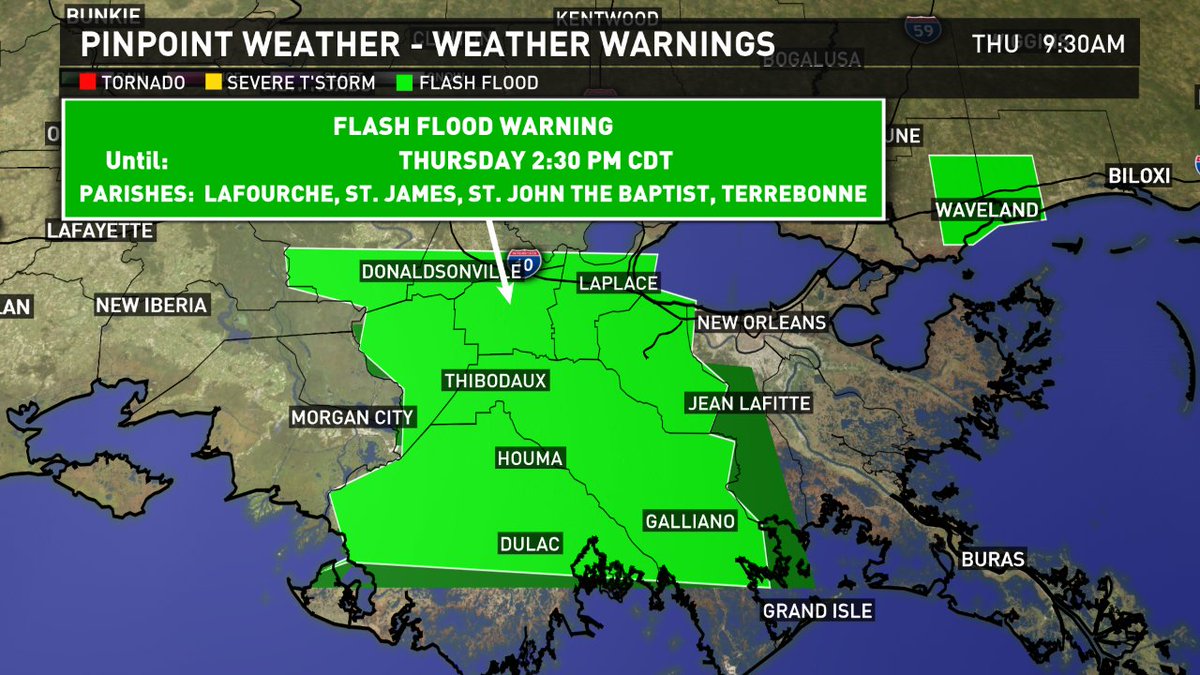
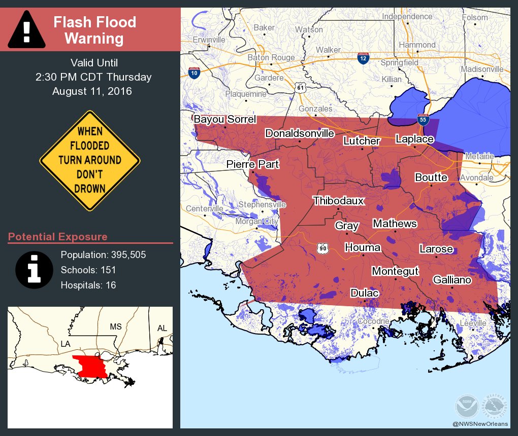
re: Flood threat on northern Gulf coast
Posted on 8/11/16 at 9:02 am to redneck
Posted on 8/11/16 at 9:02 am to redneck

MESOSCALE PRECIPITATION DISCUSSION 0544
NWS WEATHER PREDICTION CENTER COLLEGE PARK MD
954 AM EDT THU AUG 11 2016
AREAS AFFECTED...SOUTHERN LA...EXTREME SOUTHERN MS...EXTREME
SOUTHERN AL...WESTERN FL PANHANDLE
CONCERNING...HEAVY RAINFALL...FLASH FLOODING POSSIBLE
VALID 111350Z - 111930Z
SUMMARY...VERY SLOW-MOVING AND INTENSE SHOWERS AND THUNDERSTORMS
WILL BE FOCUSING OVER THE CENTRAL GULF COAST AND AREAS JUST INLAND
THROUGH EARLY AFTERNOON. EXTREMELY HEAVY RAINFALL WILL BE POSSIBLE
AND MAY RESULT IN LOCALLY SIGNIFICANT RUNOFF PROBLEMS.
DISCUSSION...A VERY BROAD AND ELONGATED AREA OF LOW PRESSURE OVER
THE CENTRAL GULF COAST THIS MORNING IS GENERATING VERY HEAVY AND
SLOW-MOVING SHOWERS AND THUNDERSTORMS FROM MUCH OF SOUTHERN LA
EAST INTO FAR SOUTHERN MS/AL AND THE WESTERN FL PANHANDLE.
THE MAIN AXIS OF CONVECTION IS FOCUSING WITHIN AN AXIS OF
CONFLUENT LOW LEVEL FLOW AND ALONG A RATHER WELL-DEFINED
INSTABILITY GRADIENT. OVER THE LAST COUPLE OF HOURS THERE HAS BEEN
SOME EXPANSION AND CONCENTRATION OF THE BROKEN BANDS OF
CONVECTION...BUT THERE CONTINUES TO BE VERY SLOW CELL MOTION AND
THIS IS BEGINNING TO RAISE SIGNIFICANT CONCERNS FOR VERY HEAVY
RAINFALL TOTALS.
THE 12Z LIX RAOB INDICATES A PWAT OF 2.69 INCHES AND A 18C
DEWPOINT AT 850 MB. THIS AIRMASS ALONG THE CENTRAL GULF COAST IS
DEEPLY TROPICAL AND EXTREMELY MOIST. IN FACT...THE CIRA-LPW
PRODUCT IS SHOWING VERY CONCENTRATED LEVELS OF MOISTURE IN THE
500/300 MB LAYER OVER SOUTHERN LA. WET-BULB ZERO LEVELS ACROSS THE
REGION ARE OVER 16000 FEET AT BOTH LCH AND LIX THIS MORNING WHICH
CONFIRMS THE DEEP WARM/MOIST COLUMN.
THE ENVIRONMENT AS A RESULT IS CONDUCIVE FOR EXTREMELY EFFICIENT
RAINFALL PRODUCTION WITHIN THE AXIS OF DEEPER CONVECTION...AND
THUS EXTREMELY HIGH RAINFALL RATES WHICH WILL LIKELY BE ON THE
ORDER OF 3 TO 4 INCHES/HR IN SOME CASES.
THE 12Z HRRR/HRRRP GUIDANCE INDICATES AN AXIS OF 4 TO 8 INCH
RAINFALL POTENTIAL THROUGH 18Z ACROSS PORTIONS OF
SOUTHERN/SOUTHEAST LA AND INTO POSSIBLY FAR SOUTHERN MS...WITH
LESSER AMOUNTS FARTHER EAST INTO THE WESTERN FL PANHANDLE.
SIGNIFICANT RUNOFF PROBLEMS AND/OR FLASH FLOODING WILL BE POSSIBLE
GIVEN THESE RAINFALL AMOUNTS...AND ESPECIALLY NEAR ANY URBANIZED
AREAS. WILL CONTINUE TO MONITOR.
ORRISON
 0
0

Posted on 8/11/16 at 9:09 am to GEAUXmedic
quote:
It's coming in waves. Yesterday was just a primer for today's event. Last night they extended the flood watch west and north to cover BTR. Yesterday's rains saturated the grounds through the coastal parishes, so they upgraded to a flash flood watch. Yesterday I got 3.2". Some areas offshore got 20+. Storms are already firing off this morning over Terrebonne and offshore. CAPE (energy) is already high and with no cap in place the chance of storms is greater. These storms will tap into the abundant moisture (yesterday's sounding had precip water values of 2.78" which according to NWS is higher than most tropical systems we have had). The storms will expand inland throughout the day with precip rates of 1-2" per hour, look for much of the same Friday, although more widespread. This morning's QPF shows 5-7" over the entire area with isolated areas of up to 10". They can't predict the exact locations of higher amounts, so I'd just say 5-7" across the area, with some locations getting up to 10, and some getting 2-5". It just depends where these storms set up and where they train, like yesterday where I got 3", compared to one of my friends 20 miles away who got 0.2" of rain.
The 12z today came in at a daily record of 2.69" and that is certainly a sign that extreme rainfall is possible. There is surprisingly good agreement b/w the Euro, Euro WRF, GFS and 4K NAM with all showing totals in the range of 20" within the area highlighted by NWS NO:

Posted on 8/11/16 at 9:10 am to rds dc
So BR should be spared like the last event we had a few months ago?
Posted on 8/11/16 at 9:12 am to rds dc
I haven't been paying attention but this might be the first FF warning for the area.

Posted on 8/11/16 at 9:18 am to LSUvegasbombed
quote:
So BR should be spared like the last event we had a few months ago?
That dukke guy says yes, BR is in the clear
Posted on 8/11/16 at 9:22 am to Spilled Milk
quote:
That dukke guy says yes, BR is in the clear
Posted on 8/11/16 at 9:26 am to dukke v
quote:
I just don't see the Baton Rouge area getting as much rain as predicted.
Why do you hate LSU?

Posted on 8/11/16 at 9:30 am to rds dc
Flash flood warning for Thibodaux area. Everyone's phone just went off in the office.
This post was edited on 8/11/16 at 9:35 am
Posted on 8/11/16 at 9:34 am to jlu03
quote:
Flash flood warning for Thibodaux area. Everyone's phone just went off in the office.
Posted on 8/11/16 at 9:41 am to rds dc
I'm watching the weather channel, and it looks like the storms are pushing south, away from BR.
Looks like dukke was right.
Looks like dukke was right.

Posted on 8/11/16 at 9:44 am to Spilled Milk
Storms may be pushing south, but do you see those bands that are coming up to BR? Those alone look like they will cause an 18 wheeler wreck and shut down 10 
Posted on 8/11/16 at 9:47 am to CuseTiger
I have a 4k tv and can see the radar on the weather channel pretty clearly, the rain is moving south.
Posted on 8/11/16 at 9:47 am to Spilled Milk
quote:
I'm watching the weather channel, and it looks like the storms are pushing south, away from BR.
Looks like dukke was right.
Actually, storms are back building to the NW along what appears to be a quasi stationary theta-e axis. Hopefully, they start getting a western motion component and don't train over the area.

Posted on 8/11/16 at 9:49 am to CuseTiger
quote:
Those alone look like they will cause an 18 wheeler wreck and shut down 10
shut your mouth!!!
Posted on 8/11/16 at 9:50 am to Spilled Milk
quote:
I have a 4k tv and can see the radar on the weather channel pretty clearly, the rain is moving south.
So you don't think new stuff can blow up or more bands can't possibly move in over the next two days?
Posted on 8/11/16 at 9:52 am to Spilled Milk
quote:
Spilled Milk
Just stop
Posted on 8/11/16 at 9:54 am to rds dc
quote:
Actually, storms are back building to the NW along what appears to be a quasi stationary theta-e axis
Is this the band/2 band area right over BR? Cause it doesn't look to be moving away from BR anytime soon. If anything, that one band split into two a half hour ago
Posted on 8/11/16 at 9:56 am to MrSmith
I'll keep you guys updated when the local on the 8s rolls around
Posted on 8/11/16 at 10:07 am to Spilled Milk
looks like there will be a training effect over the BR area soon.
Posted on 8/11/16 at 10:14 am to jlu03


 Page 5 of 6

Popular
Back to top