- My Forums
- Tiger Rant
- LSU Recruiting
- SEC Rant
- Saints Talk
- Pelicans Talk
- More Sports Board
- Fantasy Sports
- Golf Board
- Soccer Board
- O-T Lounge
- Tech Board
- Home/Garden Board
- Outdoor Board
- Health/Fitness Board
- Movie/TV Board
- Book Board
- Music Board
- Political Talk
- Money Talk
- Fark Board
- Gaming Board
- Travel Board
- Food/Drink Board
- Ticket Exchange
- TD Help Board
Customize My Forums- View All Forums
- Show Left Links
- Topic Sort Options
- Trending Topics
- Recent Topics
- Active Topics
Started By
Message

 1
1


Posted on 7/7/24 at 10:12 pm to LSUDUCKMAN67
I think he is on vacation. Haven’t seen him in the mornings this last week.
Posted on 7/7/24 at 10:16 pm to dukke v
New track is closer to metro Houston and between tomball and the Woodlands. That poster who said he never loses power in the Woodlands jinxed the hell out of this.

Posted on 7/7/24 at 10:16 pm to OWLFAN86

Posted on 7/7/24 at 10:18 pm to NorthEndZone
Posted on 7/7/24 at 10:19 pm to ABucks11
Starting to see some fecal bands in Gonzales area
Posted on 7/7/24 at 10:21 pm to charliemurphy69
Now, you’re talking the OT’s language.
This post was edited on 7/7/24 at 10:21 pm
Posted on 7/7/24 at 10:21 pm to charliemurphy69
quote:
fecal bands in Gonzales
Hmmm interdasting.
Posted on 7/7/24 at 10:21 pm to charliemurphy69
quote:
fecal bands in Gonzales area
I know Gonzales was a crappy town but fecal bands sounds like some one hit the Taco Bell too hard for supper.

Posted on 7/7/24 at 10:22 pm to ABucks11


This post was edited on 7/7/24 at 10:28 pm
Posted on 7/7/24 at 10:24 pm to charliemurphy69
quote:
fecal bands
That must come the next day after the feeder bands.

Posted on 7/7/24 at 10:26 pm to LaBR4
That's a significant shift east and goes right on top of metro Houston. Ouch
Posted on 7/7/24 at 10:29 pm to Oates Mustache
Especially if it holds, no break on the wind/rain in the NE quadrant, just all of that east side in general
This post was edited on 7/7/24 at 10:30 pm

Posted on 7/7/24 at 10:31 pm to LaBR4

Mesoscale Discussion 1554
NWS Storm Prediction Center Norman OK
1027 PM CDT Sun Jul 07 2024
Areas affected...Upper Texas Coast
Concerning...Severe potential...Watch possible
Valid 080327Z - 080600Z
Probability of Watch Issuance...60 percent
SUMMARY...Tornado threat is expected to increase across the upper
Texas Coast later tonight as Tropical Storm Beryl advances north.
DISCUSSION...Tropical Storm Beryl is advancing steadily north toward
the upper TX Coast late this evening. Over the last few hours,
organized outer convective bands have begun to spread inland, and
there have been a few stronger supercells that have moved onshore
over Brazoria into southeast Matagorda County. VWP data from HGX
exhibits gradually increasing low-level shear with 0-3km SRH now on
the order of 250 m2/s2. Low-level shear should increase markedly
over the next several hours, and there is some concern that embedded
supercells will become more common with these bands.
..Darrow/Hart.. 07/08/2024
Posted on 7/7/24 at 10:31 pm to LaBR4
Yeah, pretty much all of Houston will get the NE shitty side.
Posted on 7/7/24 at 10:32 pm to charliemurphy69
quote:
Starting to see some fecal bands in Gonzales area
Thats my feti...
Posted on 7/7/24 at 10:33 pm to Duke
Is it time to break out the sandpaper?
Posted on 7/7/24 at 10:35 pm to Roll Tide Ravens
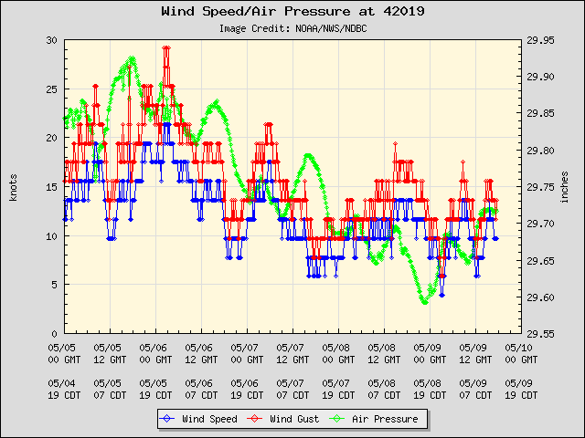
Really picking up 70 miles south of Freeport

Posted on 7/7/24 at 10:35 pm to Oates Mustache
Time for bed so I can wake up early for the pounding


Posted on 7/7/24 at 10:36 pm to The Boat
You’re in Houston area?

 Page 144 of 218

Popular
Back to top