




 17












- My Forums
- Tiger Rant
- LSU Recruiting
- SEC Rant
- Saints Talk
- Pelicans Talk
- More Sports Board
- Coaching Changes
- Fantasy Sports
- Golf Board
- Soccer Board
- O-T Lounge
- Tech Board
- Home/Garden Board
- Outdoor Board
- Health/Fitness Board
- Movie/TV Board
- Book Board
- Music Board
- Political Talk
- Money Talk
- Fark Board
- Gaming Board
- Travel Board
- Food/Drink Board
- Ticket Exchange
- TD Help Board
Customize My Forums- View All Forums
- Show Left Links
- Topic Sort Options
- Trending Topics
- Recent Topics
- Active Topics
Started By
Message
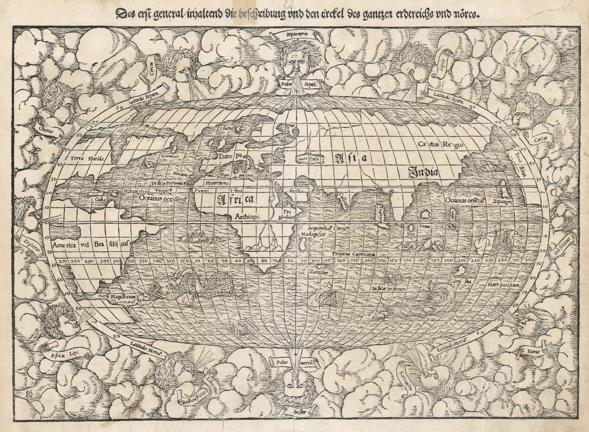
1550 Map of World Showing All of North America to be Florida
Posted on 11/6/26 at 11:37 pm
Posted on 11/6/26 at 11:37 pm
I'd vaguely heard of this before, but this is the first time I've seen an actual map from the era marking it.
They did have a pretty shitty idea of what North America looks like, and thought North America was a lot smaller than it actually was. But they marked all of what they considered North America to be Florida.
Their knowledge of Asia was pretty shitty, as was their knowledge of South America.
For whatever reason, their knowledge of Africa, while not perfect, was a lot more accurate than their knowledge of Asia, let alone their knowledge of the Americas. Actually, their map of Africa is probably better than their map of Europe itself.
They do some other strange things, like claim there's some massive bridge connecting Greenland (or some northern island that seems loosely akin to Greenland) all the way to the European mainland.
Their depiction of the shape of Britain and Ireland is terrible.They also had a horrible idea of the shape of Scandinavia.
Anyway, yeah, it's not just the eastern third of Louisiana that used to be part of Florida. The entire North American continent used to be part of Florida.
LINK
They did have a pretty shitty idea of what North America looks like, and thought North America was a lot smaller than it actually was. But they marked all of what they considered North America to be Florida.
Their knowledge of Asia was pretty shitty, as was their knowledge of South America.
For whatever reason, their knowledge of Africa, while not perfect, was a lot more accurate than their knowledge of Asia, let alone their knowledge of the Americas. Actually, their map of Africa is probably better than their map of Europe itself.
They do some other strange things, like claim there's some massive bridge connecting Greenland (or some northern island that seems loosely akin to Greenland) all the way to the European mainland.
Their depiction of the shape of Britain and Ireland is terrible.They also had a horrible idea of the shape of Scandinavia.
Anyway, yeah, it's not just the eastern third of Louisiana that used to be part of Florida. The entire North American continent used to be part of Florida.
LINK
This post was edited on 11/6/26 at 11:51 pm
Posted on 11/6/26 at 11:51 pm to UFFan
Bro it’s too fricking late for all this shite
Posted on 11/6/26 at 11:53 pm to Chad504boy
quote:
Bro it’s too fricking late for all this shite
Unless you do drugs
Posted on 11/7/26 at 12:03 am to UFFan
Yeah, bro, crossing an ocean in 1692 was like signing up to go to space in 1962.
We weren’t really good at it so the far stuff was still fairly unknown.
But those dudes had huge nuts.
We weren’t really good at it so the far stuff was still fairly unknown.
But those dudes had huge nuts.
This post was edited on 11/7/26 at 12:04 am
Posted on 11/7/26 at 12:25 am to UFFan
Ciatrick Fason
Posted on 11/7/26 at 12:42 am to S
Reche Caldwell
Posted on 11/7/26 at 4:19 am to UFFan
World is flat anyway
Posted on 11/7/26 at 4:54 am to UFFan
These are awesome.
And granted everything g you said was true, to create a map of the entire world (yet no Australia) s pretty amazing.
Cartographers had to take the explorers word for it.
This is more accurate than I could be sailing around the world.
It’s entertaining seeing what they saw back then.
Some of my favorite are looking g at the southeast US maps and seeing how off, yet accurate they were.
-The land bridge from Greenland to was most likely ice.
-the Black Sea almost reaching north to the North Sea is interesting.
-missing the actual narrowness of the danrdanelles and Bosporus is a definite oversight.
-Caspian Sea is oriented wrong
-did they know about Antarctica? Looks like they did.
And granted everything g you said was true, to create a map of the entire world (yet no Australia) s pretty amazing.
Cartographers had to take the explorers word for it.
This is more accurate than I could be sailing around the world.
It’s entertaining seeing what they saw back then.
Some of my favorite are looking g at the southeast US maps and seeing how off, yet accurate they were.
-The land bridge from Greenland to was most likely ice.
-the Black Sea almost reaching north to the North Sea is interesting.
-missing the actual narrowness of the danrdanelles and Bosporus is a definite oversight.
-Caspian Sea is oriented wrong
-did they know about Antarctica? Looks like they did.
This post was edited on 11/8/26 at 7:23 am
Posted on 11/7/26 at 5:21 am to UFFan
They should have had Extra Terrestrial’s draw the map for them…
Posted on 11/7/26 at 5:41 am to UFFan
I’ve always been amazed how “relatively” accurate maps from the 1500s and 1600s were given the technology of the time.
Posted on 11/7/26 at 6:20 am to evil cockroach
I agree. Their technology was memory, word of mouth, parchment and and a quill. They did have some very crude survey tools, but it's pretty amazing that they could come up with these kinds of maps. The sextant was not even invented
until the mid 1770s.
until the mid 1770s.
Posted on 11/7/26 at 7:04 am to UFFan
quote:you come off as a dbag criticizing these men, that did more by 30 then the majority of people today will do in their lifetimes.
UFFan
You act like they had gps 50-60 yrs after NA was discovered. Of course they had limited amounts of knowledge of what this vast new area could be.
Posted on 11/7/26 at 7:08 am to UFFan
And they named the area Florida, not think NA was just what Florida is today.
Being a UF fan you would think that would be a point of pride.
Being a UF fan you would think that would be a point of pride.
This post was edited on 11/7/26 at 7:11 am
Posted on 11/7/26 at 9:23 am to UFFan
Downvoted for laziness & posting a blind link
Posted on 11/7/26 at 9:35 am to UFFan
Maybe that is exactly what the world looked like in 1550.
Posted on 11/7/26 at 9:45 am to UFFan
I like looking at old maps like this. The sea monsters and the cherubs blowing as if they are the the winds and currents.
That is a pretty famous map as it was the first European map to show the entire circumference of the earth. Australia notably missing since Europeans didn't discover it until after 1600 sometime. Very cool map.
That is a pretty famous map as it was the first European map to show the entire circumference of the earth. Australia notably missing since Europeans didn't discover it until after 1600 sometime. Very cool map.
Posted on 11/7/26 at 10:13 am to soccerfüt
I'm more interested in Temi Aitan
Posted on 11/7/26 at 5:20 pm to IAmNERD
quote:looks like they have an island in the general area. Can’t really read what the called it.
Australia notably missing since Europeans didn't discover it until after 1600 sometime.
Posted on 11/7/26 at 5:21 pm to Stealth Matrix
quote:thanks…I was trying to figure out what that said too. Very interesting to know what they thought that was. And what it was connected to
I'm more interested in Temi Aitan
Posted on 11/7/26 at 5:27 pm to HagaDaga
quote:
looks like they have an island in the general area. Can’t really read what the called it.
The AI explanation of the islands in the pacific:
quote:
Australia had not yet been formally charted or explored by Europeans in 1550. Münster and other Renaissance cartographers populated the southern ocean with speculative landmasses, sea monsters, and islands derived from second-hand travel accounts, ancient texts (like Ptolemy), or names like Ceylon/Sumatra mixed up in translation.

 Page 1 of 2




Popular

Back to top
 Follow TigerDroppings for LSU Football News