





 0





- My Forums
- Tiger Rant
- LSU Recruiting
- SEC Rant
- Saints Talk
- Pelicans Talk
- More Sports Board
- Coaching Changes
- Fantasy Sports
- Golf Board
- Soccer Board
- O-T Lounge
- Tech Board
- Home/Garden Board
- Outdoor Board
- Health/Fitness Board
- Movie/TV Board
- Book Board
- Music Board
- Political Talk
- Money Talk
- Fark Board
- Gaming Board
- Travel Board
- Food/Drink Board
- Ticket Exchange
- TD Help Board
Customize My Forums- View All Forums
- Show Left Links
- Topic Sort Options
- Trending Topics
- Recent Topics
- Active Topics
Started By
Message
Posted on 11/7/26 at 5:59 pm to dstone12
quote:
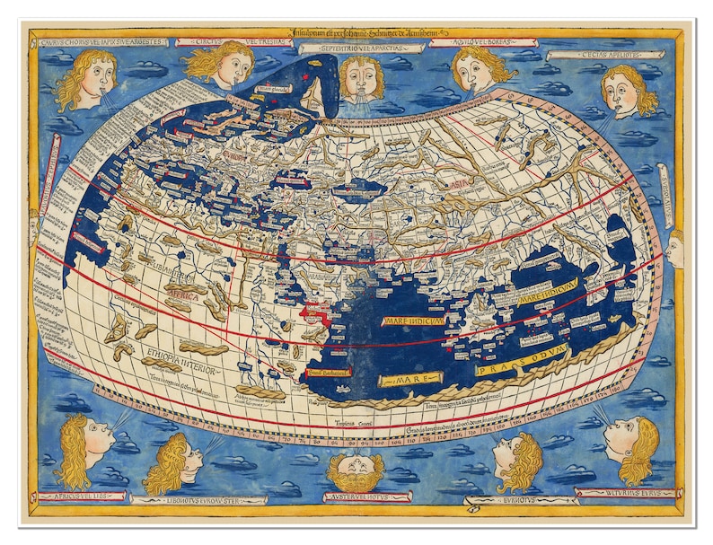
did they know about Antarctica? Looks like they d
This would’ve been their toughest quest because once you go south of SA and the jet streams are not blocked by any land, buildings, etc. it makes the ocean travel incredibly dangerous. Many ship wrecks down there.
If you’ve never seen an aerial shot of South Australia you should go check it out. Also pay attention to where all their cities are located.
This post was edited on 11/7/26 at 6:02 pm
Posted on 11/7/26 at 8:42 pm to IAmNERD
So they knew something was there, which is still interesting, even if not explored yet by Westerners
Posted on 11/8/26 at 8:46 am to IAmNERD
…went to Italy a few years ago, went through The Vatican and museums. Can’t recall exactly when their map was from but I recall being amazed how geographically accurate it was.
Posted on 11/8/26 at 9:59 am to Butch Baum
quote:
Can’t recall exactly when their map was from but I recall being amazed how geographically accurate it was.
Yeah, it is amazing how close they got with the tech, or lack thereof, that was available to them. A lot of maps made at the end of the Middle Ages and directly after were mainly based on secondhand accounts from sailors returning back to Europe combined with a little knowledge from ancient texts and a little math.
They got much closer than I would have ever been able to get by looking some stuff up in old books and descriptions from mariners.
Posted on 11/8/26 at 10:22 am to IAmNERD
Posted on 11/8/26 at 10:22 am to evil cockroach
I mean, it was a full time job surveying wilderness. People get to be pretty good at their jobs
Posted on 11/8/26 at 10:22 am to HagaDaga
quote:
I'm more interested in Temi Aitan
thanks…I was trying to figure out what that said too. Very interesting to know what they thought that was. And what it was connected to
I did a little more reading and apparently it's actually "Temistitan" which was a common exonym of the time for Tenochtitlan (Mexico City). It was apparently believed by the Spanish at one point that there were two different continents with a sea (what we now know as the Gulf) cutting both Temistitan and Florida cleanly in two.
Posted on 11/8/26 at 10:31 am to UFFan
There are older maps that are more accurate and show Antarctica. Hmmm.
Posted on 11/8/26 at 10:34 am to IAmNERD
One has to wonder where they got the sea monster design from…
Posted on 11/8/26 at 10:42 am to soccerfüt
I find it odd the least accurate part of a world map created by Europeans is Europe.
Posted on 11/9/26 at 7:25 am to UFFan
Remember this was during the age of discovery and the quest was to get there first and claim it, by naming North America as Florida they had a motive that cartographers acknowledged as "proof".
quote:
Juan Ponce de León claimed the peninsula and a vast, loosely defined northern territory (which Spain broadly called La Florida and stretched across much of the modern-day southeastern United States and beyond)
Posted on 11/9/26 at 8:14 am to UFFan
Thanks for the coolest rabbit hole of the year. 
They have a detailed cartographic map plotting the sun's course orbiting the earth through the backdrop of each astrological constellation.
Perfect Christmas gift for both TD Flat Earthers and "Always Trust the Published" Science fans.
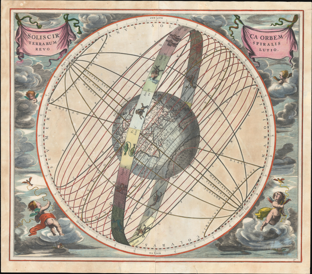
They have a detailed cartographic map plotting the sun's course orbiting the earth through the backdrop of each astrological constellation.
Perfect Christmas gift for both TD Flat Earthers and "Always Trust the Published" Science fans.
Posted on 11/9/26 at 8:54 am to dstone12
quote:
This is more accurate than I could be sailing around the world.
What's strange about it is that Europe's contours are messed up. Africa and Asia aren't too bad. I wouldn't expect them to get the New World right but you would think they would have a better idea of the Mediterranean and Scandanavia.
Posted on 11/9/26 at 9:06 am to UFFan
quote:
For whatever reason, their knowledge of Africa, while not perfect, was a lot more accurate than their knowledge of Asia, let alone their knowledge of the Americas.
The obvious reason for this is that they simply knew less about lands that were farther from them. Look at this Korean world map dated form 1402.
The accuracy is now reversed from east to west, as is to be expected:

This post was edited on 11/9/26 at 9:07 am
Posted on 11/9/26 at 5:37 pm to IAmNERD
quote:
The sea monsters
They do add a nice touch.

 Page 2 of 2





Popular

Back to top
 Follow TigerDroppings for LSU Football News