- My Forums
- Tiger Rant
- LSU Recruiting
- SEC Rant
- Saints Talk
- Pelicans Talk
- More Sports Board
- Fantasy Sports
- Golf Board
- Soccer Board
- O-T Lounge
- Tech Board
- Home/Garden Board
- Outdoor Board
- Health/Fitness Board
- Movie/TV Board
- Book Board
- Music Board
- Political Talk
- Money Talk
- Fark Board
- Gaming Board
- Travel Board
- Food/Drink Board
- Ticket Exchange
- TD Help Board
Customize My Forums- View All Forums
- Show Left Links
- Topic Sort Options
- Trending Topics
- Recent Topics
- Active Topics
Started By
Message
Fire in Santa Rosa County, FL?
Posted on 5/6/20 at 5:28 pm
Posted on 5/6/20 at 5:28 pm
Just saw this posted by a station on the book of faces:
Basically an area around Avalon Beach, bordered by I-10, Escambia Bay, the 281 Bridge, and Blackwater Bay.
What's the scoop, O-T?
quote:
To put it bluntly: if you’re in this area, get out. And take your pets with you. Santa Rosa County is opening a shelter at the Milton Community Center. It will open at 4:00pm
Basically an area around Avalon Beach, bordered by I-10, Escambia Bay, the 281 Bridge, and Blackwater Bay.
What's the scoop, O-T?
 12
12

Posted on 5/6/20 at 5:30 pm to LSUFanHouston
Friend,
Here's the current satellite image:
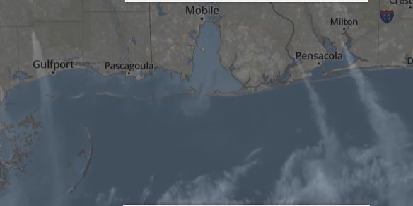
Looks to be three distinct fires, one northwest of Gulfport, one just west of Pensacola, and one between Milton and I-10.
East of Pensacola Fire:
News indicates I-10 is shut just after crossing the bay past Pensacola. Navarre seems be getting most of the smoke based on that image. Pensacola's News Journal says all people on Garcon Point south of I-10 are recommended to evacuate and that the fire has spread south of I-10. This fire is 250 acres.
West of Pensacola fire:
This fire, according to Pensacola's ABC station, is at Hurst Hammock Road in Escambia County and covers 100 acres. No evacuations ordered yet.
Northwest of Gulfport fire:
WLOX reports this is a 240 acre fire they have been battling for a few days now. Last night, the first jumped a line firefighters dug. There have been multiple fires in that area, one near Canal Road authorities suspect was arson.
Yours,
TulaneLSU
Here's the current satellite image:
Looks to be three distinct fires, one northwest of Gulfport, one just west of Pensacola, and one between Milton and I-10.
East of Pensacola Fire:
News indicates I-10 is shut just after crossing the bay past Pensacola. Navarre seems be getting most of the smoke based on that image. Pensacola's News Journal says all people on Garcon Point south of I-10 are recommended to evacuate and that the fire has spread south of I-10. This fire is 250 acres.
West of Pensacola fire:
This fire, according to Pensacola's ABC station, is at Hurst Hammock Road in Escambia County and covers 100 acres. No evacuations ordered yet.
Northwest of Gulfport fire:
WLOX reports this is a 240 acre fire they have been battling for a few days now. Last night, the first jumped a line firefighters dug. There have been multiple fires in that area, one near Canal Road authorities suspect was arson.
Yours,
TulaneLSU
This post was edited on 5/6/20 at 5:56 pm
Posted on 5/6/20 at 5:30 pm to LSUFanHouston

Posted on 5/6/20 at 5:38 pm to TulaneLSU
I drove from Mobile today and that stretch of I-10 had 3 separate fires burning on the south side of the interstate between Pascagoula and the LA state line.
Posted on 5/6/20 at 5:39 pm to Rammin TX
This is why we need to get this corona stuff under control by Hurricane Season. Can you imagine packing people into shelters?
Posted on 5/6/20 at 5:44 pm to LSUFanHouston
Where does I 10 pass in relation to those fires? Some a-hole riding around starting them ? Seems awfully coincidental that you have three burning. It’s been fairly wet out for three fires to naturally start in that same East /West line.
Posted on 5/6/20 at 5:49 pm to michael corleone
Friend,
Looking at the almanac, it appears as though that area has not had any rain since April 23, fourteen days ago. Since that time, I assume their weather is similar to ours, which has been unseasonably arid with really low humidity.
Yours,
TulaneLSU
Looking at the almanac, it appears as though that area has not had any rain since April 23, fourteen days ago. Since that time, I assume their weather is similar to ours, which has been unseasonably arid with really low humidity.
Yours,
TulaneLSU
Posted on 5/6/20 at 5:50 pm to michael corleone
Not fairly wet there
Posted on 5/6/20 at 5:51 pm to michael corleone
That area has been uniquely dry, per James Spann. Pretty sure they had wind and fire warnings out earlier today talking about that.

Posted on 5/6/20 at 6:02 pm to LSUFanHouston

Posted on 5/6/20 at 6:21 pm to TulaneLSU
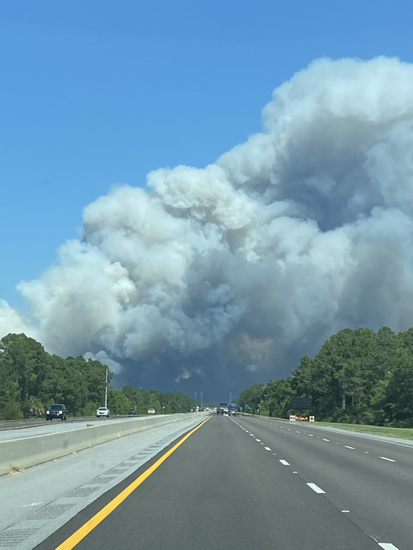
Drove through today. We had to detour through Milton on Hwy 90. Traffic was insane. We finally made it to Destin.
Posted on 5/6/20 at 6:29 pm to LSUFanHouston
The local news in Milton reported it was a permitted burn on private property that got away.
Posted on 5/6/20 at 6:49 pm to LSUFanHouston
quote:
This is why we need to get this corona stuff under control by Hurricane Season. Can you imagine packing people into shelters?
Wait until your governor tries to tell counties they can't open shelters. At least AL had county leaders who said to hell with the governor and opened them anyway when tornadoes were forecast. The next round of storms she released a statement "letting" county EMAs open shelters.
Posted on 5/6/20 at 7:15 pm to LSUFanHouston
It was originally a permitted burn that got out of control. It was about 250 acres this morning but grew rapidly as humidity dropped and wind increased out of the north. I believe one of the local TV stations may have video of it jumping the interstate, but can't remember which one. I suspect they'll still be working it tomorrow when I go back to work and days to come, it's a mess.
Posted on 5/6/20 at 7:17 pm to chris911guy
quote:
It
So is it not three fires. Two in FL and one in MS?
Posted on 5/6/20 at 7:17 pm to LSUFanHouston
It’s jumped 98 and is headed south towards Blue Mnt Beach near Thompson Rd
This post was edited on 5/6/20 at 7:18 pm
Posted on 5/6/20 at 7:18 pm to LSUFanHouston
Looks like the Blue Angels did some sort of bombing run on the way back home.
Posted on 5/6/20 at 7:21 pm to DuckManiak
Damn
Posted on 5/6/20 at 7:26 pm to chris911guy
quote:
It was originally a permitted burn that got out of control.
Hope they get it under control quickly.
Odd that a permitted burn happened when firefighters are saying it's perfect conditions of high winds and low humidity for wildfire.
Posted on 5/6/20 at 7:27 pm to notiger1997
Open up your favorite weather radar app and check the display from KEVX in Eglen AFB. Plumes from the Milton and Santa Rosa fires are readily-viewable.

 Page 1 of 5

Popular
Back to top