- My Forums
- Tiger Rant
- LSU Recruiting
- SEC Rant
- Saints Talk
- Pelicans Talk
- More Sports Board
- Fantasy Sports
- Golf Board
- Soccer Board
- O-T Lounge
- Tech Board
- Home/Garden Board
- Outdoor Board
- Health/Fitness Board
- Movie/TV Board
- Book Board
- Music Board
- Political Talk
- Money Talk
- Fark Board
- Gaming Board
- Travel Board
- Food/Drink Board
- Ticket Exchange
- TD Help Board
Customize My Forums- View All Forums
- Show Left Links
- Topic Sort Options
- Trending Topics
- Recent Topics
- Active Topics
Started By
Message

 1
1

Posted on 3/6/19 at 3:02 pm to shadowlsu
Sent
Posted on 3/6/19 at 3:50 pm to lsuson
I know a guy if you don’t want to make your own....
Posted on 3/6/19 at 5:33 pm to tke_swamprat
How does one go about learning how to make your own? I'm interested in making one for an old hummingbird unit I have on a boat.
Posted on 3/6/19 at 5:48 pm to sloopy
Can't make it for hummingbird. Only lowrance and simrad
Posted on 3/6/19 at 5:48 pm to sloopy
Not sure on hummingbird, but do a youtube search on making cards for hummingbird.
Posted on 3/6/19 at 7:02 pm to lsuson
Insight map creator was developed by navico for maps to be made from sonar or outside imagery (only legal if you're a certain someone). This writes the downloaded map in .at5 format that lowrance uses to display maps. Hummingbird will not recognize a .at5 file. This process will only work for lowrance or simrad units.
Let's just say I've had talks with lowrance about this..
FYI you can record your sonar on a memory card while on the water and upload it to IMC and make an exact contour map of your area.
Let's just say I've had talks with lowrance about this..
FYI you can record your sonar on a memory card while on the water and upload it to IMC and make an exact contour map of your area.
This post was edited on 3/6/19 at 7:09 pm
Posted on 3/6/19 at 7:51 pm to SeaPickle
quote:
Insight map creator was developed by navico for maps to be made from sonar or outside imagery (only legal if you're a certain someone).
It's my understanding that you can license from Navico for the at5 format for use in the commercial sale of maps. The imagery you use will require a separate license. The Standard map guy does not have a monopoly.
Posted on 3/6/19 at 8:10 pm to HotKoolaid
Good luck getting that license or even close to talks wtih navico about it. The criteria is nearly impossible and they aren't interested unless you bring more to the table than what they have with standard.
Posted on 3/6/19 at 8:11 pm to HotKoolaid
That is not true, they aren’t interested in giving anyone else permission. Sea pickle and i looked into this.
Also his maps are public and i found them by a simple search on the web. All he does is add names to them.
Make your own..it’s cheaper and they look better
Also his maps are public and i found them by a simple search on the web. All he does is add names to them.
Make your own..it’s cheaper and they look better

Posted on 3/6/19 at 10:00 pm to WHODAT514
quote:
All he does is add names to them.
Names can be added to the ones you can create.
Posted on 3/7/19 at 6:51 pm to WPBTiger
What is the current map version to use in SAS Planet for Google? Google is no longer updating for me in SAS Planet.
Posted on 3/8/19 at 7:29 am to Grifola
First thing you want to do is go to the map tab in SAS and change the map to Arc GIS Imagery.
Now you need to select the area you want to map.
Now you need to select the area you want to map.
Posted on 3/8/19 at 8:54 am to Uncle JackD
quote:
The colors on LA1 cards look much brighter than map cards made from google maps from pics I’ve seen. Is that how they look on fishfinders?
Not sure how the ones you have seen were made but mine are WAY better than LA-1 cards. Resolution and brightness.
Posted on 3/8/19 at 9:08 am to KLSU
I’ve never seen an LA1 card in use... only pics from their website. My current card looks just like google earth but not as clear. The LA1 pics I’ve seen look cleaner and much brighter in color.
You have pics of your card being used in fish finder?
You have pics of your card being used in fish finder?
This post was edited on 3/8/19 at 9:09 am
Posted on 3/8/19 at 9:57 am to Uncle JackD
I think some may be confusing the standard mapping LA-1 card with the legend Cartography louisiana unleashed card. Is has a "Geaux Card" version that has highlight colors and is much better than standard mappings card.
Tinkering with the card settings on a pc during the first few runs is time consuming and sucks. Once you get it figured out settings wise for what you want them making cards is a breeze. But not everyone wants to sit there for 2 weeks on a pc figuring this out.
Tinkering with the card settings on a pc during the first few runs is time consuming and sucks. Once you get it figured out settings wise for what you want them making cards is a breeze. But not everyone wants to sit there for 2 weeks on a pc figuring this out.
Posted on 3/8/19 at 10:07 am to bayouvette
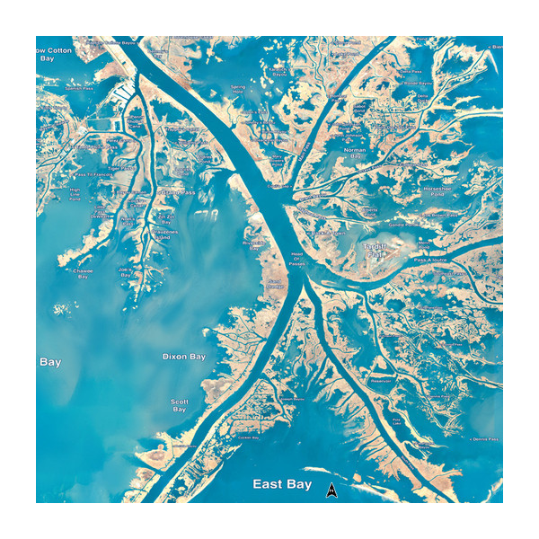
No, I’m talking about stand mapping LA1 card. I’ll post a pic of what there’s supposedly looks like... it looks nothing like a google earth made map card that I have
Posted on 3/8/19 at 10:56 am to Uncle JackD
The standard map card is an infrared image. He uses it to have a contrast between land and water. You can find his maps on gonvernment websites. However you cant download the georeferencing data to use them on your lowrance. This is why you need SAS planet. The guy who runs standard has a background of map making and developed these maps
Yall will see when making maps that in the sun it is hard to distinguish muddy marsh water and land.
Pro tip: if using arcgis or google style maps you need to play with the contrast settings. Bing maps have much better contrast
Yall will see when making maps that in the sun it is hard to distinguish muddy marsh water and land.
Pro tip: if using arcgis or google style maps you need to play with the contrast settings. Bing maps have much better contrast
This post was edited on 3/9/19 at 4:06 am
Posted on 3/8/19 at 11:03 am to SeaPickle
Makes sense. Appreciate the explanation 
Posted on 3/8/19 at 3:14 pm to Uncle JackD
quote:
No, I’m talking about stand mapping LA1 card. I’ll post a pic of what there’s supposedly looks like... it looks nothing like a google earth made map card that I have
That odd blue colored map is only visible at certain zoom ranges. When you zoom in close enough for the map to be useful the image changes colors and gets worse.

 Page 4 of 14

Popular
Back to top