- My Forums
- Tiger Rant
- LSU Recruiting
- SEC Rant
- Saints Talk
- Pelicans Talk
- More Sports Board
- Fantasy Sports
- Golf Board
- Soccer Board
- O-T Lounge
- Tech Board
- Home/Garden Board
- Outdoor Board
- Health/Fitness Board
- Movie/TV Board
- Book Board
- Music Board
- Political Talk
- Money Talk
- Fark Board
- Gaming Board
- Travel Board
- Food/Drink Board
- Ticket Exchange
- TD Help Board
Customize My Forums- View All Forums
- Show Left Links
- Topic Sort Options
- Trending Topics
- Recent Topics
- Active Topics
Started By
Message
re: Major Louisiana Flood Event
Posted on 3/10/16 at 12:18 pm to Twenty 49
Posted on 3/10/16 at 12:18 pm to Twenty 49
quote:
Did your friend just drive into door-handle deep water on purpose before he had to bail out? Or did he hydroplane into that predicament?
He got off on the exit to turn around and go back to Shreveport. The car in front of him made it through so he went on. Then, he said "the water started rising." So, he opted to try to go straight through (and the truck is on the ramp where it is going up). He said "the water rose in about 20 seconds and the truck died." He forced the door open and waded out in armpit deep water.
He went over to the Relay Station, cold and soaking wet, but it was locked and closed. But, they had truckers staying there so they opened it up for him and let him dry his clothes.
His story, not mine
 2
2

Posted on 3/10/16 at 12:19 pm to 225bred
quote:
If I'm trying to drive from Ruston to BR, when is my best gap to shoot??
Nighttime it appears, which is a pretty bold/stupid move given the conditions around your area.
I really don't know what you should do, but good luck.

Posted on 3/10/16 at 12:20 pm to slackster
Thanks man, my route is 167 to I49 to 190 if that helps.
Posted on 3/10/16 at 12:22 pm to 225bred
Just stay up to date with the DOTD road closures before you head out.

Posted on 3/10/16 at 12:22 pm to LaBR4
Well for me it's not about saving the country club...
It's about Wallace Lake creeping north through creeks and ditches and coming into my back yard. me and other people who may not be aware that the lake has definitely jumped the banks and whatnot. From now on I'll take into account the median price of homes before I bring any potential news to the thread, thanks for the privilege check...
It's about Wallace Lake creeping north through creeks and ditches and coming into my back yard. me and other people who may not be aware that the lake has definitely jumped the banks and whatnot. From now on I'll take into account the median price of homes before I bring any potential news to the thread, thanks for the privilege check...
Posted on 3/10/16 at 12:26 pm to Fletch F Fletch
quote:
From now on I'll take into account the median price of homes before I bring any potential news to the thread, thanks for the privilege check...
I don't think he meant any harm by his comment, but I understand it hits close to home for you. Good luck.

Posted on 3/10/16 at 12:28 pm to chinhoyang
quote:
he opted to try to go straight through (and the truck is on the ramp where it is going up). He said "the water rose in about 20 seconds and the truck died." He forced the door open and waded out in armpit deep water.
Moral of the story: Don't drive through flood waters, even if you "got a truck, baw!" Doesn't take much for things to go south.

Posted on 3/10/16 at 12:29 pm to Fletch F Fletch
quote:
thanks for the privilege check...
wtf, I golf there every once in a while.

Posted on 3/10/16 at 12:30 pm to chinhoyang
fish swimming in streets at ULM campus
Posted on 3/10/16 at 12:31 pm to Duke
quote:
Nope. The low driving all the moisture out of the Gulf isn't moving very quickly. So where SE LA is will catch little disturbances going around the low.
It's not like your typical cold front that has a low racing off to the NE and a trailing squall line. Should see multiple rounds of rain before this system finally moves on out.
Yea, it's a highly unusual setup. How often do you see a line of storms push east and then see development behind it that moves NW! (some model runs actually stall the line and then have the line of storms start heading back NW) The models, esp the HRRR, continue to struggle with this setup. The bottom line is that more rain is on the way.
The worrisome thing is that the pattern looks very wet on into April. It will be nearly impossible to see another event like this but any additional heavy rain events are going to have the potential to set off more flooding.
Posted on 3/10/16 at 12:32 pm to slackster
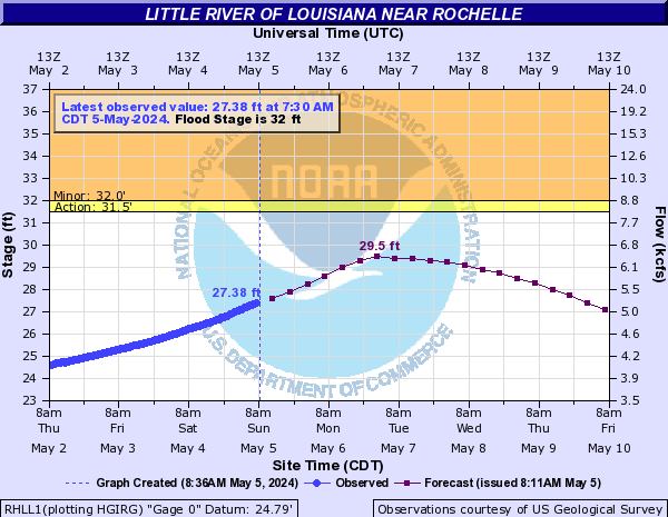
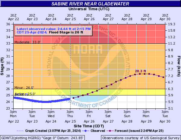
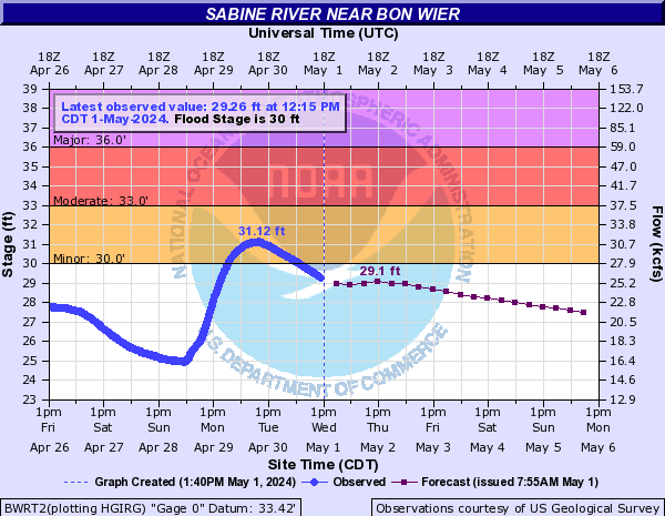
Look at these river forecasts:

quote:
46 There will be catastrophic flooding of numerous homes with several thousand acres of land inundated as well. All roadways closed or severely flooded with all communities in the river floodplain isolated.
44 Severe flooding of several thousand acres with several homes facing flooding. U.S. Highway 165 will be flooded and closed and several communities will be isolated by high water. Several homes in the georgetown community will be flooded by high water.
40 There will be severe flooding problems with several homes near georgetown louisiana facing flooding. Preparations for a major flood should be rushed to completion. In addition, state highway 500 will be flooded and closed. Small communities such as zenoria and rochelle will likely be cut off by high water. Travel by boat will become necessary in a few locations.
quote:
90 Expect near record flooding with nearly all homes suffering from flooding in and around the lake. Travel by boat will be the only effective means of travel as all secondary roadways will be flooded and impassable.
86 Expect severe flooding of several homes on the lake with nearly all roads around the lake suffering flooding in low areas.
quote:
40 U.S. Highway 80 will be flooded and closed. Several thousand acres of land will remain flooded for several days.
38 The approaches to U.S. Highway 271 floods at the Sabine River bridge. Expect major flooding to continue for several more days.
36 Expect moderate to severe flooding with some secondary roadways near the river to be closed. Also homes will be threatened with flooding and preparations should be completed for a major flood.
Posted on 3/10/16 at 12:32 pm to BottomlandBrew
Don't stop and think about driving through the water while you're sitting in the water. Gotta commit
Posted on 3/10/16 at 12:39 pm to LaBR4
If I misunderstood the intent of your banghead, I apologize. i'll meet you at P&S and buy you a six pack, ha.
Posted on 3/10/16 at 12:39 pm to slackster
Some of the Sabine River gauges are going to obliterate previous records:
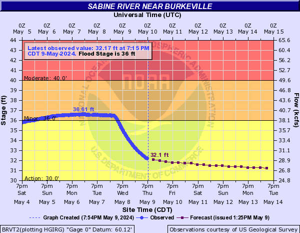

quote:
48.05 The river has reached flood of record. Widespread major to catastrophic flooding occurs.
47 Major flooding occurs.
45 Moderate flooding occurs.
43 Residential flooding in the River Bend Subdivision occurs.
quote:
43.5 The river is at its unofficial highest gage reading set in April 1913. Widespread catastrophic flooding will occur.
38.97 The river is at its flood of record. Widespread major to catastrophic flooding will occur.
36 Major lowland flooding will occur. Sabine Sands Road has about one to three feet of water covering the road.
35 Expect several secondary roads in the Merryville area near the river to be closed.
33 Moderate lowland flooding will occur. Low-lying roads and a few homes have some flooding between Bon Wier and Merryville. Camp houses along the river in Southwest Vernon Parish begin to flood.
quote:
32.7 The river has reached its unofficial highest gage reading previously set in May 1884. Widespread catastrophic flooding will occur.
29.98 The river is at its flood of record. Widespread major to catastrophic flooding will occur.
29 Major flooing occurring leaving the town of Deweyville isolated. Numerous homes are flooded.
27.9 This flooding will be similar to the flooding expierenced in the flood of March 2001. Homes in Deweyville have water in them.
27 Widespread moderate lowland flooding will occur. Homes in Deweyville closest to the river are flooded. Flooding of homes in the Indian Lakes and River Oaks sections will also occur. Low-lying roads and a few homes in Southwest Beauregard Parish have some flooding.
26.8 Deweyville schools may be closed due to school bus routes being flooded.
26 Moderate lowland flooding will occur. The lowest homes between Deweyville and the river begin to flood, especially in the Indian Lakes and River Oaks sections. Low-lying roads and a few homes in Southwestern Beauregard Parish have some flooding.
Posted on 3/10/16 at 12:40 pm to Fletch F Fletch
quote:
i'll meet you at P&S and buy you a six pack
No worries. But yeah..I like High Life.
511.org
This has been posted, but really is the best to keep up with road closures.
Posted on 3/10/16 at 12:42 pm to rds dc
quote:
How often do you see a line of storms push east and then see development behind it that moves NW! (some model runs actually stall the line and then have the line of storms start heading back NW) The models, esp the HRRR, continue to struggle with this setup. The bottom line is that more rain is on the way.
It's wild! My jaw dropped when I saw the -10 standard deviations with the heights over Mexico.
Looking forward to canoeing to LSU tomorrow.
Posted on 3/10/16 at 12:43 pm to LaBR4
Any more word on the dam vibrations at Toledo Bend. Pretty hard to believe it can handle sustained flow over 200k cfps also i would imagine the Sabine is going to flood a bunch of people that didn't even get much rain.
Posted on 3/10/16 at 12:45 pm to slackster
Yesterday the forecast was a 34 foot crest on the Little River. Now they're saying 46 
Posted on 3/10/16 at 12:45 pm to Fletch F Fletch
quote:
i'll meet you at P&S and buy you a six pack, ha.
Can't believe that they are going to put another CVS at the corner next to P&S. I am sure that I will be spending plenty of money at that one too.
You a member at ST Fletch?
Posted on 3/10/16 at 12:46 pm to bayoudude
The NWS doesn't have the lake level even posted.
It is sunny in Desoto Parish, which is bad since the heat will generate stronger storms when the next wave arrives.
It is sunny in Desoto Parish, which is bad since the heat will generate stronger storms when the next wave arrives.

 Page 39 of 102

Popular
Back to top