- My Forums
- Tiger Rant
- LSU Recruiting
- SEC Rant
- Saints Talk
- Pelicans Talk
- More Sports Board
- Fantasy Sports
- Golf Board
- Soccer Board
- O-T Lounge
- Tech Board
- Home/Garden Board
- Outdoor Board
- Health/Fitness Board
- Movie/TV Board
- Book Board
- Music Board
- Political Talk
- Money Talk
- Fark Board
- Gaming Board
- Travel Board
- Food/Drink Board
- Ticket Exchange
- TD Help Board
Customize My Forums- View All Forums
- Show Left Links
- Topic Sort Options
- Trending Topics
- Recent Topics
- Active Topics
Started By
Message
How accurate is OnX hunting app with property lines
Posted on 1/14/26 at 6:03 am
Posted on 1/14/26 at 6:03 am
I have been using it and the few times I was on public and got even close to private it seemed pretty accurate to me so far. Until yesterday. I was on a wma and it looked to have a decent amount of land I could keep walking according to the app but all of a sudden it said posted and had a box stand on what OnX was showing as public land still.
I turned around bc not worth it but I figured the app mapping would be more accurate than that.
I turned around bc not worth it but I figured the app mapping would be more accurate than that.
 10
10

Posted on 1/14/26 at 6:17 am to GravelLotinCanada
I’ve noticed it to be off 20-50’ especially on north and south boundaries in S AL. You can usually look at the aerials and notice the change in timber stands do not match the lines shown.
Posted on 1/14/26 at 6:29 am to GravelLotinCanada
The app is getting data from the parish/county. OnX is a great guideline, but I wouldn’t try to use it in court.
Posted on 1/14/26 at 6:44 am to GravelLotinCanada
Land Surveyor here, as mentioned OnX is only as good as the local county/parish assessors and/or mapping office. Some places it is great. Some are absolutely horrific. I see it everyday.
As mentioned above, lines of occupation (change in timber stands, chamge in vegetation, etc) is a great indicator to change of possession especially if it is anywhere near an OnX line.
As mentioned above, lines of occupation (change in timber stands, chamge in vegetation, etc) is a great indicator to change of possession especially if it is anywhere near an OnX line.
Posted on 1/14/26 at 7:45 am to GravelLotinCanada
At the WMA I hunt in MS, there’s typically a fire guard around any private land for obvious reasons. They try to burn various blocks every other yr.
Posted on 1/14/26 at 8:11 am to GravelLotinCanada
In the marshes it will get you in a bind REAL quick lots of what it calls public is private and I’ve witnessed some nasty disagreements over it.
In the woods where I hunt in MS it’s pretty accurate but certainly not perfect.
In the woods where I hunt in MS it’s pretty accurate but certainly not perfect.
Posted on 1/14/26 at 8:42 am to Da Hammer
quote:
In the marshes it will get you in a bind REAL quick lots of what it calls public is private and I’ve witnessed some nasty disagreements over it
Some of the disagreements are the result of people “claiming” what they think is theirs based on generational information that was intentionally or unintentionally inaccurate.
Posted on 1/14/26 at 8:47 am to Da Hammer
quote:
In the marshes it will get you in a bind REAL quick lots of what it calls public is private
There's a lot of bullshite in those marshes too.
Posted on 1/14/26 at 10:56 am to GravelLotinCanada
Here is an image from my property. The OnX line is on top of my fence. But not sure if previous owner put the fence on the property line (he did everything else wrong).
GPS is off by 10-15’. I was standing south of the fence on this screen grab.
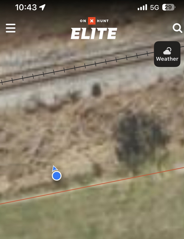
GPS is off by 10-15’. I was standing south of the fence on this screen grab.
Posted on 1/14/26 at 12:00 pm to GravelLotinCanada
In my experiences with situations where I know where the boundary is.....10-15 feet off.
Posted on 1/14/26 at 12:02 pm to Antib551
quote:
Land Surveyor here, as mentioned OnX is only as good as the local county/parish assessors and/or mapping office. Some places it is great. Some are absolutely horrific. I see it everyday.
This. But even the parish assessors site disclaimer states not to be used for legal purposes. It's only a rough guide. Property lines always vary.
Posted on 1/14/26 at 12:09 pm to geauxbrown
At my house where I know exactly where the lines are its about +/- 10 feet.
Really really really good IMO. Not legal dispute good, but plenty good enough for "can I hunt here or not"
Really really really good IMO. Not legal dispute good, but plenty good enough for "can I hunt here or not"

Posted on 1/14/26 at 12:12 pm to GravelLotinCanada
pretty sure it uses data from tax assessor maps. each parish/county keeps it's own database (usually hired out), but the OnX ap is only going to be as accurate as that particular parish/county is, and they aren't always super accurate. if you wanted to get nats arse, you'd have to read legal descriptions (and survey it)
Posted on 1/14/26 at 1:58 pm to TopWaterTiger
quote:100 percent. The lines come from ding dongs inches assessor office drawing up legal descriptions and slapping it into/adjacent to existing tract lines.
This. But even the parish assessors site disclaimer states not to be used for legal purposes. It's only a rough guide. Property lines always vary.
Its purpose is to show you generally where you are at. Nothing specific.
Posted on 1/14/26 at 3:15 pm to GravelLotinCanada
It’s close, but I wouldn’t trust it to be absolutely perfect
Posted on 1/14/26 at 3:20 pm to SmoothBox
10’-15’ is half a turn row and will get ya a certified letter from topwatertiger. 
Posted on 1/14/26 at 4:48 pm to GravelLotinCanada
I’ve noticed having a bad cell signal makes a big difference in the accuracy of what it’s showing you too.

 Page 1 of 1


Popular
Back to top